Area Overview for Baddeley, Milton & Norton Ward
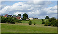
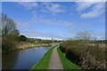
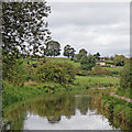
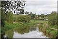
Photos of Baddeley, Milton & Norton Ward
Area Information
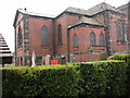
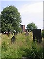
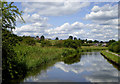
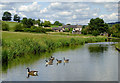
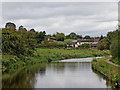
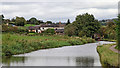
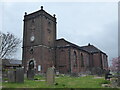
Baddeley, Milton & Norton Ward occupies 9.5 square kilometres within the Stoke-on-Trent City Council area of the West Midlands. This district currently houses a population of 4,421 people across residential, commercial, and historical zones. You will find the neighbourhood spans from Baddeley Green and Milton to the historic sector of Norton-in-the-Moors. The location sits approximately at coordinates 53.0608°N, 2.1527°W, placing it within the wider urban fabric of the Potteries. This electoral ward acts as a unitary authority division bordered by Light Oaks, Sneyd Green, and Abbey Hulton. Your daily life here centres around a mix of urban convenience and regional history. The area traces roots back to medieval times as part of the Norton-in-the-Moors parish, with records of coal mining dating back to 1316. Families linked to the locality appear in subsidy rolls from the 14th century. Milton once stood near the Caldon Canal and served as a chapelry established in 1865. The wider area joined the County Borough of Stoke-on-Trent in 1922 following the federation of the Six Towns. You are buying into an established community with deep commercial origins. Notable historical features include Baddeley Hall, Heakley Hall, and Ridgeway Hall. The Church of St Philip and St James marks the junction of Leek Road and Caldon Canal. Living in Baddeley, Milton & Norton Ward means accessing a location that has evolved from a medieval settlement into a modern residential ward.
- Area Type
- District Borough Unitary Ward
- Area Size
- 9.5 km²
- Population
- 4421
- Population Density
- 466 people/km²
Demographics
The community profile of Baddeley, Milton & Norton Ward reflects a predominantly mature population. The median age for residents is 70 years old. This demographic structure indicates that the area is primarily occupied by older households. You are looking at a neighbourhood where most residents have outlived many of their initial peers. Only 33% of residents are under the median age, meaning the majority are seniors. This age distribution often influences local spending patterns and community engagement styles. Current statistics show that 67% of households in the ward own their homes outright or with a mortgage. This figure leaves 33% of households as renters, social tenants, or residing in shared ownership schemes. This relatively high ownership rate suggests long-term residents and family stability within the established stock. While the data does not specify ethnic breakdowns or religious affiliations, the historical context of Norton-in-the-Moors suggests a settled population with traditional roots. The ward includes diverse accommodation types, though specific proportional splits are not detailed in the current figures. You should consider that a household with a median age of 70 likely prioritises accessibility, proximity to healthcare, and convenience. The area has adapted to support these residents following its incorporation into the larger city structure. Demographic figures confirm this is an area for retirement living or long-term established families rather than a hub for young commuters.
Household Size
Accommodation Type
Tenure
Ethnic Group
Religion
Household Composition
Age
Household Deprivation
NS-SEC
Explore more demographic insights in this area
Go to Demographics tabPlanning
Planning Constraints
- Flood RiskPremium
- Ramsar Wetland SitesPremium
- Area of Outstanding Natural BeautyPremium
- Protected Nature ReservePremium
- Protected WoodlandPremium
- Crime RiskPremium