Area Overview for B95 5BZ
Photos of B95 5BZ
Area Information
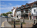
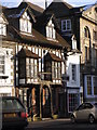
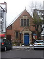
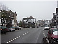
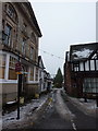
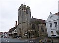
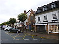
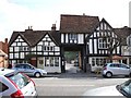
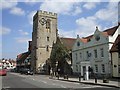
B95 5BZ, part of the medieval market town of Henley-in-Arden in Warwickshire, offers a quiet, historic lifestyle for a small population of 1,620. The area’s dense ribbon settlement along the High Street features over 150 listed buildings from medieval to Victorian eras, creating a preserved charm rare in modern developments. With a population density of 1,169 people per square kilometre, this compact postcode area blends rural tranquillity with accessible amenities. Daily life revolves around the town’s historic core, where independent shops, local pubs, and community events thrive. Proximity to Stratford-upon-Avon and Birmingham via rail links ensures connectivity without sacrificing the village’s character. Families and older residents dominate, drawn by low crime rates and a stable housing market. The area’s compact size means residents can walk to key services, while the surrounding countryside offers open spaces for recreation. For those seeking a slower pace with historical depth, B95 5BZ provides a distinct alternative to urban living.
- Area Type
- Postcode
- Area Size
- Not available
- Population
- 1620
- Population Density
- 1169 people/km²
B95 5BZ is primarily an owner-occupied area, with 77% of homes owned by residents rather than rented. The accommodation type is predominantly houses, which is typical for smaller towns with historic settlements. This suggests a market skewed towards family homes rather than high-density housing, making it attractive for buyers seeking stability and space. The compact nature of the postcode area means housing stock is limited, but the high proportion of owner-occupied properties indicates strong local demand. For buyers, this translates to a competitive market with potential for long-term value retention. The presence of historic homes along the High Street adds unique character, though modern developments are minimal. Prospective buyers should consider the area’s small size, which may limit availability, and its proximity to larger towns for additional services. The focus on houses also means fewer rental options, appealing to those prioritising property ownership.
House Prices in B95 5BZ
No properties found in this postcode.
Energy Efficiency in B95 5BZ
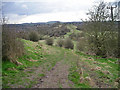
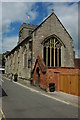
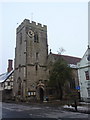
Life in B95 5BZ is shaped by its historic High Street, lined with over 150 listed buildings and independent retailers. Nearby amenities include five retail outlets, such as Co-op Henley-In and Morrisons, ensuring everyday shopping needs are met. The area’s character is defined by its medieval heritage, with landmarks like the 15th-century church and Heritage Centre offering cultural enrichment. For leisure, the surrounding countryside provides walking and cycling opportunities, though specific parks are not listed. The town’s small size fosters a close-knit community, with local pubs and events reinforcing social ties. Rail stations like Henley and Wootton Wawen connect residents to broader networks, while the High Street’s historic charm adds to daily life’s distinctiveness. The blend of practical amenities and preserved architecture makes B95 5BZ ideal for those valuing convenience, history, and a slower pace of life.
Amenities
Schools
Near B95 5BZ, three independent schools serve the area: Ardenhurst School, Arden Lawn School, and Henley-in-Arden Montessori Primary School. All are independent institutions, offering alternative educational models to state-run schools. Henley-in-Arden Montessori Primary School holds an Ofsted rating of satisfactory, indicating it meets basic standards but may not excel in all areas. The presence of multiple independent schools suggests a demand for private education, likely driven by the area’s older demographic and family-oriented community. While no state schools are listed, the independent options cater to parents seeking structured or specialised learning environments. However, the limited variety of school types may restrict choices for families preferring state education. The overall school mix reflects the area’s character as a historic, low-density town with a focus on traditional values and community-centric institutions.
| Rank | School | Type | Entry gender | Ages |
|---|
Explore more schools in this area
Go to Schools tabDemographics
The population of B95 5BZ has a median age of 47, with the majority of residents aged 30–64. This suggests a community of established families and older adults, contributing to a stable, mature demographic. Home ownership is high at 77%, reflecting a preference for long-term residency over rental properties. The area is predominantly composed of houses, indicating a focus on family-friendly housing rather than apartments or flats. The predominant ethnic group is White, aligning with broader regional trends. While specific data on deprivation is absent, the high home ownership and low crime score imply a relatively affluent and secure environment. The age profile suggests a balance between active professionals and retirees, fostering a community with shared interests in local heritage and amenities. This demographic mix supports a cohesive social fabric, with schools and services tailored to family needs.
Household Size
Accommodation Type
Tenure
Ethnic Group
Religion
Household Composition
Age
Household Deprivation
NS-SEC
Explore more demographic insights in this area
Go to Demographics tabPlanning
Planning Constraints
- Flood RiskPremium
- Ramsar Wetland SitesPremium
- Area of Outstanding Natural BeautyPremium
- Protected Nature ReservePremium
- Protected WoodlandPremium