Area Overview for B93 9AN
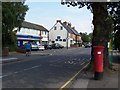
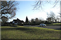
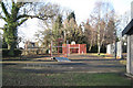
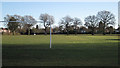
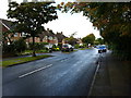
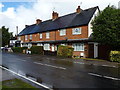
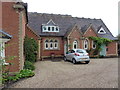
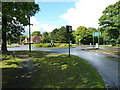
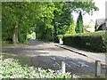
Photos of B93 9AN
Area Information
B93 9AN represents a specific postcode sector within the Dorridge and Hockley Heath Ward, housing a population of 1,643 people across 3,540 square metres. This small residential cluster balances suburban convenience with distinct rural elements, situated south-west of Solihull. The area functions as a settled community where history meets modern infrastructure, originally emerging as a wooded clearing known as Derrech in 1400 and later developing as a railway town following the arrival of the Great Western Railway in 1852. Residents enjoy proximity to major routes like the Old Warwick Road and Stratford Road, which historically connected the coach stops to wider markets. The local character reflects an affluent suburban-rural mix, featuring substantial family homes, converted mansions, and open farmland turned into estates. You will find landmarks such as Dorridge Park, gifted in 1965, and the Church of St Thomas in neighbouring Hockley Heath. British Airways and other modern developments coexist with ancient features like the Four Ashes trees, which have marked the local boundary since 1662. Living in this village environment means lower population density pressures within the immediate cluster, yet you remain connected to the broader West Midlands through efficient rail links. The area avoids planning constraints such as AONB or Ramsar sites, ensuring development respect while maintaining its village atmosphere.
- Area Type
- Postcode
- Area Size
- 3540 m²
- Population
- 1643
- Population Density
- 2554 people/km²
Homes in B93 9AN reflect a settled market characterised by high owner-occupation rates. With 72% of the population owning their property, the area is not a rental hotspot but a destination for families seeking permanence. The accommodation type is clearly defined as houses, meaning you will find significant detached or semi-detached stock rather than the high-rise blocks common in urban zones. This cluster of 1,643 residents sits within a broader context of the Dorridge and Hockley Heath Ward, where development has historically faced local resistance, preserving the integrity of existing estates. You are likely looking at village-style homes or large residential properties that have evolved from mid-19th-century expansions or earlier industrial sites. The history of the area includes the transformation of the Midland Counties Idiots Asylum into residential use and the late-1990s developments at the Middlefield Hospital site, which have been absorbed into the current housing stock. These properties accommodate substantial families, consistent with the high home ownership percentage. The lack of flats in the data confirms a market focused on single-family dwellings. If you intend to live here, you join a group of residents who have invested in local stability. The property landscape is further enriched by nearby landmarks like Umberslade Hall, tied to the historic Muntz family, adding to the appeal of the residential mix surrounding this postcode.
House Prices in B93 9AN
Showing 8 properties
| Address | Type | Beds | Baths | Last Sale Price | Last Sale Date | |
|---|---|---|---|---|---|---|
| 121 Widney Road, Bentley Heath, Solihull, B93 9AN | house | - | - | £457,000 | Nov 2021 | |
| 125 Widney Road, Bentley Heath, Solihull, B93 9AN | house | - | - | £470,000 | Dec 2015 | |
| 119 Widney Road, Bentley Heath, Solihull, B93 9AN | house | - | - | £335,000 | Sep 2011 | |
| 117 Widney Road, Bentley Heath, Solihull, B93 9AN | Semi-detached | - | - | £225,000 | Dec 2005 | |
| 113 Widney Road, Bentley Heath, Solihull, B93 9AN | Semi-detached | - | - | £137,500 | Sep 1999 | |
| 111 Widney Road, Bentley Heath, Solihull, B93 9AN | Semi-detached | - | - | - | - | |
| 123 Widney Road, Bentley Heath, Solihull, B93 9AN | house | - | - | - | - | |
| 115 Widney Road, Bentley Heath, Solihull, B93 9AN | Semi-detached | - | - | - | - |
Energy Efficiency in B93 9AN
Living in B93 9AN grants you practical access to a variety of amenities within short reach. Retail options include Asda Widney, Co-op Bentley, and Sainsburys Dorridge, allowing you to manage weekly shopping needs efficiently. Dining and socialising happen around prominent local spots such as the Drum and Monkey pub, originally the White Lion Inn around 1860. For leisure, Dorridge Park offers open green space, while the King George VI Memorial Hall provides community event hosting. You are also close to historic sites like the Four Ashes trees and can reach Hockley Heath Primary Academy for family activities. Your convenience extends to five railway stations nearby, including Dorridge, Widney Manor, and Solihull, giving you flexible travel options. For those who prefer motor vehicles, the area sits on routes like Stratford Road, connecting to the M42 and M40 motorways. Proximity to Birmingham International Railway Station and Birmingham International Airport adds further utility for business or holiday trips. Shopping diversity means you can visit five different retail venues without driving far. The presence of these named facilities, from the Sainsburys in Dorridge to the train stations, confirms that daily life involves little traffic congestion or long commutes to basics. You reside in a place where historic pubs and modern supermarkets coexist within a practical radius.
Amenities
Schools
| Rank | School | Type | Entry gender | Ages |
|---|
Explore more schools in this area
Go to Schools tabDemographics
The community in B93 9AN is defined by stability and maturity, with a median age of 47 years. Most residents are adults aged between 30 and 64 years, creating a household profile likely dominated by families in their peak earning years rather than young professionals or retirees. Home ownership stands at a robust 72%, indicating that the vast majority of local families have purchased their properties directly. This high ownership rate aligns with the area's accommodation type, which consists primarily of houses rather than flats or shared housing. The demographic composition is predominantly White, reflecting the traditional village structure of the Dorridge and Hockley Heath Ward. With a population density noted as 464,144 people per square kilometre, the area offers a sense of space despite being a clustered postcode. The age profile suggests you are living in a neighbourhood where families have settled, evidenced by the low fluctuation of turn-over compared to flashier city-centre rentals. Children often attend Hockley Heath Primary Academy, established on its 1913 site, while older residents may utilise facilities like the King George VI Memorial Hall, built in 1892. The social fabric appears tightly woven, with 72% of the population owning their homes, fostering a long-term investment mindset rather than a transient lifestyle.
Household Size
Accommodation Type
Tenure
Ethnic Group
Religion
Household Composition
Age
Household Deprivation
NS-SEC
Explore more demographic insights in this area
Go to Demographics tabPlanning
Planning Constraints
- Flood RiskPremium
- Ramsar Wetland SitesPremium
- Area of Outstanding Natural BeautyPremium
- Protected Nature ReservePremium
- Protected WoodlandPremium