Area Overview for B93 0LB
Photos of B93 0LB

Area Information
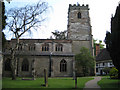
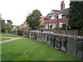
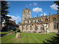
Living in B93 0LB offers a unique blend of village charm and modern convenience within the Metropolitan Borough of Solihull. This specific postcode covers a residential cluster in Knowle, a large village situated approximately 5 km east-southeast of Solihull town centre. The area lies mid-way between Birmingham and Warwick on the A4141, bridging the historic Arden region of Warwickshire with contemporary housing solutions. While the wider Knowle Ward houses around 11,000 people, this specific cluster supports a smaller population of 1,635 residents. The settlement balances its agricultural origins with significant 20th-century suburban expansion, retaining historic character alongside modern developments. Walkers can explore the Conservation Area, which focuses on the High Street and a 15th-century church, before finding ease of access to regional hubs. The area sits currently at a population density of 865 people per square kilometre, reflecting a tight-knit but residentially active community. You will find the village transformed from an agricultural settlement into a democratic residential hub, defined by its retention of historic timber-framed buildings and a five-lock canal flight. Daily life here combines proximity to Birmingham International with the slower pace of a traditional village. The square miles of the village offer a distinct identity, where the charm of a village atmosphere persists despite post-war expansion. This mix makes the area practical for those seeking roots without isolation.
- Area Type
- Postcode
- Area Size
- Not available
- Population
- 1635
- Population Density
- 865 people/km²
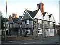
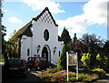
The property market in B93 0LB is defined by a strong leaning towards owner-occupation. You will find that 61 percent of local households own their homes, creating a stable environment absent of the volatility often seen in high-rent zones. This high ownership rate suggests that the area attracts buyers seeking to settle rather than investors flipping properties rapidly. Accommodation types are primarily houses, which is typical for a village of this history and size. The housing stock likely includes the numerous historic timber-framed buildings dating from the 16th and 17th centuries, alongside Victorian terraced cottages featured along the High Street. Potential buyers looking at homes in this specific cluster can expect a mix of older character properties and more modern extensions resulting from post-war development. The low crime risk score of 67 out of 100 further supports the idea that this is a safe, family-oriented market. Since the area is a specific residential cluster with a population of 1,635, it feels less like a sprawling estate and more like a distinct village community. The average population density of 865 people per kilometre square means you will not face the isolation of the countryside, yet you avoid the density of the city. This balance makes the area particularly attractive for those prioritising stability and safety in their search for a home.
House Prices in B93 0LB
No properties found in this postcode.
Energy Efficiency in B93 0LB
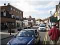
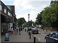
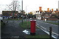
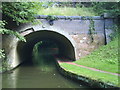
Your daily lifestyle in B93 0LB benefits from a compact range of amenities within practical reach. Retail options include the Tesco Knowle, Asda Widney, and the Co-op Bentley, ensuring you do not need to travel far for groceries. For rail commuters, Dorridge and Widney Manor stations offer convenient travel times to Birmingham, while Birmingham International Airport provides broader national reach. Leisure activities centre around the Grand Union Canal, which features a flight of five locks. This waterway includes a thriving boatyard and two pubs within walking distance, offering a classic British leisure experience. The village square anchors the social life, featuring the 15th-century church and the historic Guild House. The Conservation Area protects the High Street, preserving the character of a village atmosphere despite modern housing expansions. You can enjoy walks along the canal or explore the listed buildings, such as the Berrow Homes dating back to 1886. The area also pays homage to its history with the Soldiers' Chapel, opened in 1921 as a memorial to the 81 local men who died in the First World War. This blend of shopping, transport, and heritage creates a rounded daily routine. Residents can run errands in the village, enjoy a boat trip, or travel to the city, all without needing a long commute. The presence of these specific venues ensures a varied and convenient lifestyle.
Amenities
Schools
| Rank | School | Type | Entry gender | Ages |
|---|
Explore more schools in this area
Go to Schools tabDemographics
The community in B93 0LB is characterised by a mature demographic profile. The median age for residents sits at 47 years, with adults aged 30 to 64 representing the most common age range. This suggests a population composed largely of families, empty nesters, and established professionals rather than young students or transient workers. You are unlikely to find a student-heavy zone here; instead, homes cater to those with deep financial roots. Home ownership stands as a defining feature of the area, with 61 percent of households owning their property outright. This majority ownership signals long-term stability and a lack of transient renting behaviour. Accommodation types predominantly consist of houses, reflecting the village's evolution from farmland into a family-centric residential zone. The predominant ethnic group is White, aligning with the broader demographic makeup of many Solihull villages. These figures paint a picture of a stable neighbourhood where residents have stayed for decades. The lower median age compared to major urban centres indicates a community focused on long-term planning rather than short-term living. Such demographics often correlate with high engagement in local governance and community events.
Household Size
Accommodation Type
Tenure
Ethnic Group
Religion
Household Composition
Age
Household Deprivation
NS-SEC
Explore more demographic insights in this area
Go to Demographics tabPlanning
Planning Constraints
- Flood RiskPremium
- Ramsar Wetland SitesPremium
- Area of Outstanding Natural BeautyPremium
- Protected Nature ReservePremium
- Protected WoodlandPremium