Area Overview for B92 7RL
Photos of B92 7RL


Area Information
B92 7RL is a small, tightly knit postcode area in England’s West Midlands, encompassing a cluster of residential properties in the village of Olton. With a population of just 1,342, it retains the character of a suburban village despite its proximity to Solihull. The area’s history is rooted in medieval agriculture, with its name deriving from the Saxon *Oulton*, meaning “old town.” Today, it is a quiet, stable community where homes are predominantly owner-occupied, reflecting a mature demographic. The village’s layout, shaped by 19th-century railway development, offers a blend of historical charm and modern convenience. Residents benefit from proximity to Solihull’s amenities while retaining the low-density, residential feel of a village. The area’s low crime risk and excellent broadband connectivity make it appealing for those seeking a balance between tranquillity and accessibility. For buyers, B92 7RL represents a rare opportunity to own a property in a historically significant yet practical location, where daily life is defined by community ties and ease of transport.
- Area Type
- Postcode
- Area Size
- Not available
- Population
- 1342
- Population Density
- 4369 people/km²
B92 7RL is predominantly an owner-occupied area, with 70% of homes owned by residents rather than rented. The accommodation type is exclusively houses, which is unusual for modern housing markets but aligns with the area’s historical development as a semi-rural village. This suggests a limited housing stock, likely comprising semi-detached or detached properties built in the 19th and 20th centuries. The small population and focus on owner-occupation mean the market is not saturated with rental properties, potentially offering buyers a chance to secure a home with long-term value. However, the area’s size—covering only a small cluster of residences—means competition for properties could be fierce. Buyers should consider the proximity to Solihull for additional amenities, as the village itself offers limited commercial or retail development. The dominance of houses also implies that flats or apartments are rare, catering to those seeking space and privacy over density.
House Prices in B92 7RL
No properties found in this postcode.
Energy Efficiency in B92 7RL
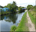
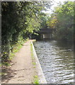
Living in B92 7RL offers a mix of practical convenience and historical character. Within reach are five retail outlets, including Tesco Solihull and Co-op Lyndon, providing essential shopping. The area’s proximity to Birmingham International Airport and railway stations like Spring Road and Acocks Green makes travel to major cities or airports effortless. For leisure, Olton Mere—a reservoir and open water body—offers recreational opportunities, while St Margaret’s Church, a Grade II listed building, adds cultural value. The village’s layout, shaped by 19th-century railway development, ensures a low-density, peaceful environment. Residents can enjoy a quiet lifestyle while benefiting from easy access to Solihull’s amenities, from schools to healthcare. The presence of multiple railway stations and retail hubs means daily errands are efficient, while the historical sites and open spaces provide a sense of continuity with the past. This blend of practicality and heritage defines the area’s appeal.
Amenities
Schools
| Rank | School | Type | Entry gender | Ages |
|---|
Explore more schools in this area
Go to Schools tabDemographics
The population of B92 7RL is 1,342, with a median age of 47, indicating a community of established adults aged 30–64. This age group dominates, suggesting a stable, long-term resident base. Home ownership stands at 70%, with houses being the primary accommodation type, reflecting a preference for family-friendly, semi-detached or detached properties. The predominant ethnic group is White, though specific diversity metrics are not provided. The low median age and high home ownership rate suggest a community with strong local ties and limited turnover. The absence of detailed deprivation data means no direct conclusions can be drawn about economic hardship, but the overall profile points to a middle-income demographic. This aligns with the area’s character as a mature, low-density village where property values are likely to hold steady. The age profile also implies a demand for schools, healthcare, and community facilities, which are likely well-served by nearby Solihull.
Household Size
Accommodation Type
Tenure
Ethnic Group
Religion
Household Composition
Age
Household Deprivation
NS-SEC
Explore more demographic insights in this area
Go to Demographics tabPlanning
Planning Constraints
- Flood RiskPremium
- Ramsar Wetland SitesPremium
- Area of Outstanding Natural BeautyPremium
- Protected Nature ReservePremium
- Protected WoodlandPremium