Area Overview for B91 3DU
Photos of B91 3DU


Area Information
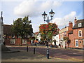
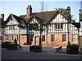
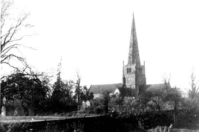
Living in B91 3DU offers a distinct experience within the historic core of Solihull town. This specific postcode covers a small residential cluster measuring just 3,216 square metres. With a population of 1,798 residents, the area maintains a high density of 1,383 people per square kilometre. This compact size defines daily life as closely knit and immediate, contrasting with the more suburban sprawl found elsewhere in the West Midlands. The location sits at the centre of St Alphege Ward, part of the Metropolitan Borough of Solihull. Residents benefit from proximity to the historic St Alphege Church, a Grade I listed medieval Gothic parish church standing at the head of High Street. Although founded around 1220, the area retains its identity as a planned medieval settlement established by the de Limsey family between 1170 and 1180. The community encompasses the role of a historic trade hub, anchored by religious landmarks including St Helen's Church. You can expect a neighbourhood where history and modern living intersect, defined by specific coordinates near postcode B91 1AY. The area size means that amenities and residents are within immediate practical reach, shaping a lifestyle centred on local connectivity rather than vast distances.
- Area Type
- Postcode
- Area Size
- 3216 m²
- Population
- 1798
- Population Density
- 1383 people/km²
The property market in B91 3DU is defined by a specific scarcity and a clear preference for ownership over tenancy. Flats constitute the primary form of accommodation within this small residential cluster. With a total area of only 3,216 square metres, new large-scale developments are unlikely to change the existing stock significantly. The high home ownership rate of 66 per cent signals that this postcode is a established residential zone rather than a transient rental hub. Buyers looking at homes in B91 3DU should expect a market dominated by existing stock rather than newly built properties. This concentration of flats suggests a vertical living arrangement suited to the high density of 1,383 people per square kilometre. The limited physical size of the area means that buyers must compete for a finite number of units. This dynamic often drives up values for available properties, as supply cannot easily expand to meet demand from professionals or families seeking a foothold in Solihull town. The area appeals to those who prioritise convenience over space, given the proximity to High Street and transport links. Prospective purchasers should focus entirely on the available inventory within this small boundary, as the market does not cater to large detached family homes but rather to the compact living styles provided by flats.
House Prices in B91 3DU
Showing 1 properties
| Address | Type | Beds | Baths | Last Sale Price | Last Sale Date | |
|---|---|---|---|---|---|---|
| Mell Square Ltd, 700 Warwick Road, Silhill, Solihull, B91 3DU | retail_financial | - | - | - | - |
Energy Efficiency in B91 3DU
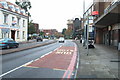
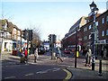
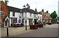
Daily life in B91 3DU is defined by immediate access to major retail and transport hubs. You are within walking distance or short travel time to Sainsburys Solihull, Morrisons Solihull, and Tesco Solihull. Having five retail options nearby ensures that groceries, groceries, and everyday necessities are always available without leaving the town centre. The location also places you close to five railway stations, including Solihull Railway Station, Widney Manor Railway Station, and Olton Railway Station. This density of transport options provides flexibility for commuting and leisure travel. Furthermore, you have direct access to two major aviation and rail nodes: Birmingham International Airport and Birmingham Intl Railway Station. For residents who fly frequently or travel to London centrally, these amenities are practically integrated into your neighbourhood. The area also features notable historical landmarks like St Alphege Church, which adds cultural depth to the daily routine. The presence of multiple supermarkets supports a self-sufficient lifestyle, while the rail network connects you to the broader city. You live in a setting where convenience is built into the geography, removing the need for long trips to satisfy basic household or travel needs.
Amenities
Schools
Families in B91 3DU have access to a range of educational institutions nearby, and you do not need to travel far for schooling options. The immediate vicinity includes Blossomfield Centre, St Augustine's Catholic Primary School, St Peter's Catholic School, and Malvern Hall School. These primary and secondary entry points serve the local catchment, ensuring that daily commutes to school are short for most children. St Augustine's Catholic Primary School and St Peter's Catholic School offer faith-based education, catering to families seeking religious instruction alongside academic development. Malvern Hall School provides another primary option, completing the local cluster of state-provided education. Further afield, Solihull College & University Centre serves as a sixth-form establishment, offering post-compulsory education for older students. The mix of primary and sixth-form provision means that residents can secure education from early childhood through to the end of compulsory schooling without relying heavily on busier outer borough routes. The presence of these named schools suggests a focus on local educational needs. You should consider traffic patterns during these times, as the density of 1,383 people per square kilometre can lead to local congestion. The variety of school types ensures that different educational philosophies are represented directly within the reach of the postcode area.
| Rank | School | Type | Entry gender | Ages |
|---|
Explore more schools in this area
Go to Schools tabDemographics
The community in B91 3DU is characterised by a mature demographic profile with a median age of 47 years. Adults aged between 30 and 64 years represent the most common age range, suggesting a population stabilised for mid-stage family life or professional maturity. Home ownership stands at 66 per cent, indicating a residential base where long-term settlers often hold leases or freeholds rather than renting. This high ownership rate suggests stability and a commitment to the locality. The predominant ethnic group within this cluster is White, reflecting the historical settlement patterns of the Solihull region. In terms of physical housing, Flask accommodation types dominate the stock. This aligns with the high density of 1,383 people per square kilometre, as flats maximise living space within the limited 3,216 square metre footprint. The area does not skew towards younger commuters or transient populations. Instead, the data points to established households who have rooted themselves deeply in the ward. This ownership structure often correlates with lower mobility rates, creating a predictable neighbourhood environment where residents know one another and maintain local institutions like the nearby schools and church teams.
Household Size
Accommodation Type
Tenure
Ethnic Group
Religion
Household Composition
Age
Household Deprivation
NS-SEC
Explore more demographic insights in this area
Go to Demographics tabPlanning
Planning Constraints
- Flood RiskPremium
- Ramsar Wetland SitesPremium
- Area of Outstanding Natural BeautyPremium
- Protected Nature ReservePremium
- Protected WoodlandPremium