Area Overview for B90 3SE
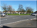
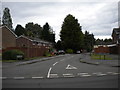
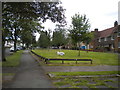
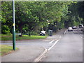
Photos of B90 3SE


Area Information
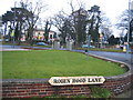
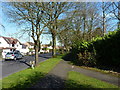
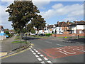
B90 3SE, part of the Olton area in Solihull, is a small residential cluster with a population of 1,685, retaining the character of a suburban village despite its proximity to Solihull. Historically rooted in agriculture, the area transformed after the 1869 railway station opened, fostering a residential community. Today, it blends quiet village life with modern amenities. The median age of 47 suggests a mature demographic, with a strong presence of adults aged 30–64. Olton’s heritage includes landmarks like Olton Mere, a reservoir turned recreational space, and St Margaret’s Church, a Grade II listed building. The area’s compact size means it feels intimate, with Warwick Road and the Birmingham-Warwick Road providing connectivity. Residents benefit from proximity to Birmingham International Airport and rail links, while the surrounding landscape offers pockets of greenery. Living here suits those seeking a balance between suburban tranquillity and access to urban resources.
- Area Type
- Postcode
- Area Size
- Not available
- Population
- 1685
- Population Density
- 4044 people/km²
B90 3SE is primarily an owner-occupied area, with 77% of homes owned by residents rather than rented. The accommodation type is predominantly houses, not flats or apartments, which is typical of suburban villages like Olton. This suggests a housing stock suited to families or individuals seeking larger properties. The small size of the postcode area means the market is limited, with fewer properties available compared to larger urban zones. Buyers should consider that the area’s character—blending village charm with proximity to Solihull—may appeal to those prioritising space and low crime rates. However, the limited supply could mean competition for available homes, especially given the area’s stable population. The predominance of houses also implies that rental options are scarce, making it a less viable choice for those seeking short-term accommodation.
House Prices in B90 3SE
No properties found in this postcode.
Energy Efficiency in B90 3SE
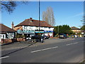
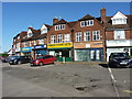
Living in B90 3SE offers a mix of practical amenities and quiet suburban charm. Nearby retail options include Tesco Hall, Co-op Northfield, and Aldi Hall, providing everyday shopping needs. The area’s rail links—Yardley Wood, Hall Green, and Olton stations—connect residents to Birmingham and other cities, while proximity to Birmingham International Airport makes travel convenient. Recreational spaces include Olton Mere, a reservoir turned public park, and St Margaret’s Church, a listed building offering historical interest. The village retains a distinct character, with Warwick Road serving as a central thoroughfare. While the area is small, its amenities cater to daily life, from grocery shopping to commuting. The blend of green spaces and accessible transport ensures a balance between leisure and practicality, ideal for those seeking a settled lifestyle without sacrificing connectivity.
Amenities
Schools
| Rank | School | Type | Entry gender | Ages |
|---|
Explore more schools in this area
Go to Schools tabDemographics
The population of B90 3SE is 1,685, with a median age of 47, indicating a community skewed towards middle-aged and older residents. The most common age range is 30–64, suggesting a stable population of professionals and families. Home ownership is high at 77%, reflecting a community of long-term residents rather than renters. The area is predominantly composed of houses, not flats, aligning with the suburban character of Olton. The predominant ethnic group is White, though specific data on diversity is not provided. With 77% of homes owned outright, the area likely experiences lower housing turnover, fostering a sense of continuity. The absence of detailed deprivation data means the quality of life remains unquantified, but the low crime score of 73/100 implies a relatively safe, stable environment for residents.
Household Size
Accommodation Type
Tenure
Ethnic Group
Religion
Household Composition
Age
Household Deprivation
NS-SEC
Explore more demographic insights in this area
Go to Demographics tabPlanning
Planning Constraints
- Flood RiskPremium
- Ramsar Wetland SitesPremium
- Area of Outstanding Natural BeautyPremium
- Protected Nature ReservePremium
- Protected WoodlandPremium