Area Overview for B90 3EY
Photos of B90 3EY

Area Information
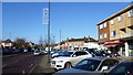
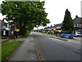
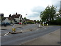
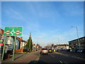
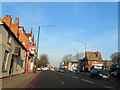
Living in B90 3EY means being part of a small, tightly knit residential cluster in Shirley, part of Solihull’s western borough. With a population of 1,746, the area blends urban convenience with historical roots. Originally a rural settlement in Warwickshire, Shirley evolved into a residential suburb by the mid-20th century, shaped by post-war housing estates and commercial development. The area is bisected by Stratford Road (A34), a historic turnpike that now connects to major transport hubs. Residents benefit from proximity to Shirley Heath Junior School, a primary school with an outstanding Ofsted rating, and a network of rail stations, including Shirley and Solihull, which link to Birmingham and beyond. The area’s character is defined by its mix of residential housing, commercial activity, and proximity to Solihull’s economic corridors, making it appealing for families and commuters. Its compact size means amenities are within practical reach, though buyers should consider nearby areas for broader options.
- Area Type
- Postcode
- Area Size
- Not available
- Population
- 1746
- Population Density
- 3520 people/km²
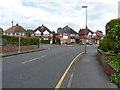
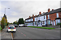
B90 3EY is predominantly an owner-occupied area, with 75% of homes owned by residents rather than rented. The accommodation type is exclusively houses, which is unusual for a small postcode area and suggests a focus on single-family homes. This contrasts with nearby areas that may include flats or apartments. The high home ownership rate indicates a long-term residential commitment, potentially driven by the area’s established character and proximity to amenities. However, the small size of the postcode means the housing stock is limited, and buyers may need to consider adjacent areas for more options. The presence of houses rather than rental properties also implies a lower turnover rate, which could be advantageous for those seeking stability but may limit availability for first-time buyers.
House Prices in B90 3EY
No properties found in this postcode.
Energy Efficiency in B90 3EY
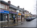
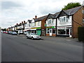
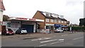
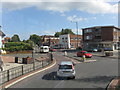
Residents of B90 3EY have access to a range of amenities within practical reach. The area includes five retail venues, such as Lidl Sears, Co-op Shirley, and M&S Sears, offering everyday shopping and dining options. Rail stations like Shirley and Solihull provide easy access to public transport, while nearby Birmingham International Airport and railway stations cater to longer-distance travel. Though the data does not explicitly mention parks, the area’s historical context includes green spaces like Marshall Lake, which may offer recreational opportunities. The mix of retail, transport, and proximity to commercial hubs creates a convenient lifestyle, blending suburban tranquility with urban accessibility.
Amenities
Schools
The nearest school to B90 3EY is Shirley Heath Junior School, a primary school with an outstanding Ofsted rating. This indicates high-quality education for younger children, though no secondary schools are listed in the data. The absence of secondary school information means families with older children may need to look beyond the immediate area for comprehensive schooling. The presence of a top-rated primary school is a significant draw for families, offering a strong foundation for early education. However, buyers should verify the availability of secondary schools in nearby postcode areas to ensure long-term educational needs are met.
| Rank | School | Type | Entry gender | Ages |
|---|
Explore more schools in this area
Go to Schools tabDemographics
The community in B90 3EY is predominantly composed of adults aged 30–64, with a median age of 47. This suggests a mature, established population, likely with long-term ties to the area. Home ownership is high at 75%, indicating a stable residential base with fewer renters. The accommodation type is primarily houses, reflecting a preference for single-family living over flats or apartments. The predominant ethnic group is White, which aligns with broader demographic trends in Solihull. The absence of specific data on deprivation or diversity means the community’s socioeconomic profile is not fully detailed, but the high home ownership rate and age range suggest a relatively affluent, settled population. This profile may appeal to buyers seeking a stable, family-oriented environment with minimal turnover.
Household Size
Accommodation Type
Tenure
Ethnic Group
Religion
Household Composition
Age
Household Deprivation
NS-SEC
Explore more demographic insights in this area
Go to Demographics tabPlanning
Planning Constraints
- Flood RiskPremium
- Ramsar Wetland SitesPremium
- Area of Outstanding Natural BeautyPremium
- Protected Nature ReservePremium
- Protected WoodlandPremium