Area Overview for B90 3BE
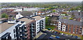
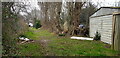
Photos of B90 3BE


Area Information
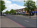
Living in B90 3BE defines daily life within the urban electoral ward of Shirley West, located in the Metropolitan Borough of Solihull. This specific postcode cluster represents a small residential community approximately three miles southeast of Solihull town centre along the Stratford Road. The area sits at the intersection of distinct neighbourhoods, bordered by Yardley Wood to the north and west, with Bromsgrove district to the south. Historically, this part of Shirley developed from a farming settlement recorded as 'Syrley' around 1240, evolving into an independent parish by 1843 with the construction of St James' Church. The landscape includes notable sites such as the Shirley Institute, founded in 1901, and the Berry Mound Iron Age Hill Fort. You are purchasing a home in a location that balances suburban quiet with significant historical depth. The residential cluster forms part of a larger suburb that transitioned through rapid growth in the 1920s and 30s, featuring post-WWII housing developments like the Cranmore estate. With a population of 2,297, B90 3BE offers a contained living environment where residents benefit from proximity to Junction 4 of the M42 motorway. This link connects you directly to Birmingham and Stratford-upon-Avon. The area is situated near the broader Shirley hub, providing access to historic landmarks like the Red Lion and Saracens Head pubs, while maintaining its identity as a distinct ward within the metropolitan borough.
- Area Type
- Postcode
- Area Size
- Not available
- Population
- 2297
- Population Density
- 4743 people/km²
The property market in B90 3BE is characterised by a strong majority of owner-occupied homes. With 78 per cent home ownership, this postcode cluster functions primarily as a market for buyers looking to purchase rather than a rental hub. The predominant accommodation type is houses, which means you will typically find family-sized detached or semi-detached properties rather than purpose-built flats or conversions. This stock profile suggests a community of established residents who have bought into the local market over time. When searching for homes in B90 3BE, you are looking at a specific residential cluster that forms part of the wider Shirley area. The high ownership percentage indicates that buying here often involves entering an existing owner-occupier market. This can influence house prices and negotiation dynamics compared to areas with high rental turnover. The presence of houses aligns with the demographic reality of a median age of 47, where families often seek larger self-contained properties. While the broader Shirley area may show varied deprivation levels, this specific postcode focuses on housing needs compatible with family life. The market reflects a preference for traditional UK housing forms over modern apartment living, fitting the local character of suburban Solihull.
House Prices in B90 3BE
No properties found in this postcode.
Energy Efficiency in B90 3BE
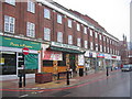
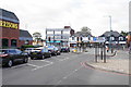
Daily life in B90 3BE benefits from immediate access to major retail outlets, rail services, and transport hubs within practical reach. Residents can visit Asda Shirley, Aldi Shirley, and Iceland Shirley for everyday shopping needs without travelling far. These shops form the core retail backbone for the residential cluster. For public transport, five rail stations serve the immediate vicinity, including Shirley Railway Station and Solihull Railway Station. Additionally, five major transport and travel hubs are nearby, such as Birmingham International Airport and Birmingham New Street station, offering extensive connections beyond local transit. The area location allows you to reach these amenities while living in a residentially focused environment. The proximity to Solihull and Shirley means you enjoy urban convenience without being in the town centre itself. Historical features like the Shirley Institute and St James' Church are part of the broader neighbourhood character you inherit as a resident. The presence of specific retail chains like Iceland and Aldi signals a focus on practical family shopping. You do not need to venture deep into Birmingham city centre for basic groceries or travel planning. The integration of these amenities creates a lifestyle where work, travel, and shopping remain accessible from your front doorstep.
Amenities
Schools
Families near B90 3BE have access to specific educational institutions that meet national standards. The primary school closest to this postcode is Haslucks Green School. This institution holds a 'good' Ofsted rating, indicating that local education authorities and inspectors have verified its quality. There are no secondary schools or special educational needs schools listed in the immediate vicinity data for this specific postcode cluster. This means parents must look to surrounding wards for secondary education options beyond primary level. The mix of school types here is straightforward but limited by the current data scope. With Haslucks Green School providing good primary education, you have a solid start for younger children attending schools near B90 3BE. The absence of listed secondary or further education colleges in the direct vicinity suggests that families often plan for transfers as children grow. Primary education in this cluster relies on established institutions like Haslucks Green School which serve the immediate residential needs of the 2,297 population in the area. Prospective parents should verify travel times to secondary schools in wider Solihull when considering homes in this specific postcode.
| Rank | School | Type | Entry gender | Ages |
|---|
Explore more schools in this area
Go to Schools tabDemographics
The community in B90 3BE reflects a settled population with a median age of 47 years. Most residents fall within the adult age range of 30 to 64 years, indicating a neighbourhood dominated by working-age individuals and established families rather than young students or retired elders. You will find that 78 per cent of households in this postcode own their properties outright or with a mortgage. This high ownership rate suggests a stable community where people have chosen to put down roots locally. Justice is evident in the accommodation type data, which confirms that houses are the predominant housing stock. This contrasts with areas where flats or apartments dominate, meaning you will find detached, semi-detached, and terraced homes rather than high-rise living. The demographic profile also shows that the White ethnic group is the predominant population within this specific cluster. This profile aligns with the area's history as part of the broader Shirley settlement near Olton. While the area is less prosperous than some neighbouring zones, it avoids the extremes of deprivation seen in other sections of Solihull. The combination of high home ownership and a house-focused stock creates a residential fabric suited to long-term living rather than short-term tenancies.
Household Size
Accommodation Type
Tenure
Ethnic Group
Religion
Household Composition
Age
Household Deprivation
NS-SEC
Explore more demographic insights in this area
Go to Demographics tabPlanning
Planning Constraints
- Flood RiskPremium
- Ramsar Wetland SitesPremium
- Area of Outstanding Natural BeautyPremium
- Protected Nature ReservePremium
- Protected WoodlandPremium