Area Overview for B90 1PZ
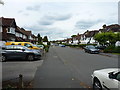
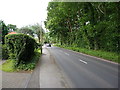
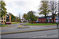
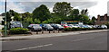
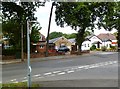
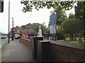
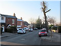
Photos of B90 1PZ


Area Information
Living in B90 1PZ means being part of a small, tightly knit residential cluster within the Shirley area of Solihull. With a population of just 1,247, this postcode reflects a quiet, established community nestled approximately 3 miles southeast of Solihull town centre. The area’s character stems from its historical roots as a farming settlement, now reimagined as a suburban hub along Stratford Road. Residents benefit from proximity to major transport routes, including the M42 motorway and Stratford Road, which links to Birmingham and Stratford-upon-Avon. Daily life here is shaped by a blend of older housing stock and post-war developments, creating a mix of traditional and modern living. The area’s compact size means amenities and services are within practical reach, while its location offers easy access to larger urban centres without the density of city living. For those seeking a balance between tranquillity and connectivity, B90 1PZ provides a snapshot of suburban England, where community ties and practical infrastructure coexist.
- Area Type
- Postcode
- Area Size
- Not available
- Population
- 1247
- Population Density
- 3497 people/km²
The property market in B90 1PZ is characterised by a high rate of home ownership (73%) and a predominance of houses over flats or other forms of accommodation. This suggests a community of long-term residents rather than a rental-heavy market, with properties likely to be older, family homes rather than newer developments. The small size of the postcode area means the housing stock is limited, but the focus on houses implies a more spacious, traditional feel compared to high-density areas. Buyers should consider that the market may be less dynamic, with fewer new builds and a reliance on existing properties. The area’s proximity to Solihull and Birmingham offers potential for commuters, though the small cluster of homes means competition for available properties could be keen. For those prioritising stability and established living, B90 1PZ’s housing profile presents a straightforward, if unexciting, proposition.
House Prices in B90 1PZ
No properties found in this postcode.
Energy Efficiency in B90 1PZ
The lifestyle in B90 1PZ is shaped by its proximity to a network of practical amenities, including retail outlets such as Iceland Shirley, Aldi Shirley, and M&S Stratford Rd Solihull BP. These shops cater to everyday needs, while nearby railway stations like Shirley and Yardley Wood provide access to broader regional services. The area’s connection to Birmingham International Airport and metro points such as Grand Central New Street adds to its convenience for travel. Though the immediate vicinity lacks expansive parks or leisure facilities, the surrounding Shirley area includes historical sites like St James’ Church and the Berry Mound Iron Age Hill Fort, offering cultural and recreational opportunities. The mix of retail, transport, and heritage sites creates a balanced lifestyle, where residents can enjoy local shopping and commuting ease while maintaining links to the area’s historical character. The compact nature of the postcode means daily life revolves around nearby hubs, ensuring a sense of community without sacrificing accessibility.
Amenities
Schools
Residents of B90 1PZ have access to a range of educational institutions, including St James Church of England Voluntary Aided Junior School, a primary school with no Ofsted rating listed, and Tudor Grange Primary Academy, St James, which holds an outstanding Ofsted rating. For independent education, Kingswood School is available, offering a good Ofsted rating. This mix of state and independent options provides families with flexibility, whether they seek a faith-based primary education or a more academically focused independent school. The presence of an outstanding-rated primary school suggests high standards in local education, which is a significant draw for families prioritising academic outcomes. However, the absence of secondary schools in the immediate area means students may need to travel to nearby towns for further education. Overall, the school landscape reflects a commitment to quality education, though parents should plan for potential commutes to secondary-level institutions.
| Rank | School | Type | Entry gender | Ages |
|---|
Explore more schools in this area
Go to Schools tabDemographics
The population of B90 1PZ is predominantly middle-aged, with a median age of 47 and the largest age group falling within 30–64 years. This suggests a community of established professionals and families, many of whom are likely homeowners. Home ownership here is high at 73%, with houses being the primary accommodation type, indicating a stable, long-term resident base. The predominant ethnic group is White, reflecting the area’s historical development as a largely homogenous suburb. While no specific deprivation data is provided, the absence of extreme deprivation markers in surrounding areas like Shirley East implies a generally moderate quality of life. The demographic profile suggests a community focused on stability, with fewer transient populations and a strong emphasis on family-oriented living. This aligns with the presence of good local schools and proximity to transport links, catering to the needs of working-age adults and families.
Household Size
Accommodation Type
Tenure
Ethnic Group
Religion
Household Composition
Age
Household Deprivation
NS-SEC
Explore more demographic insights in this area
Go to Demographics tabPlanning
Planning Constraints
- Flood RiskPremium
- Ramsar Wetland SitesPremium
- Area of Outstanding Natural BeautyPremium
- Protected Nature ReservePremium
- Protected WoodlandPremium