Area Overview for B90 1AN
Photos of B90 1AN


Area Information
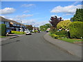
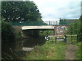
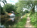
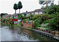
Living in B90 1AN means being part of a tightly knit residential cluster in England’s West Midlands, where the population of 1,655 is spread across a compact area at a density of 661 people per square kilometre. This postcode lies in a historically significant region, near the headwaters of the River Cole on the Birmingham Plateau. The area’s character is shaped by its proximity to both rural and urban landscapes, with easy access to transport networks and local amenities. Daily life here is defined by a balance of quiet residential living and connectivity to nearby towns. The area’s history, including its role in the 19th-century industrial era and its ties to the former RAF Wythall site, adds depth to its modern identity. Residents benefit from a low crime rate and minimal environmental constraints, making it a practical choice for those seeking a stable, community-focused environment without the pressures of high-density urban living.
- Area Type
- Postcode
- Area Size
- Not available
- Population
- 1655
- Population Density
- 661 people/km²
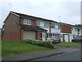
The property market in B90 1AN is dominated by owner-occupied homes, with 91% of properties in private hands. This high rate of home ownership suggests a community of long-term residents who view the area as a place to settle rather than a transient location. The accommodation type is predominantly houses, which aligns with the suburban nature of the postcode. This contrasts with areas dominated by rental properties or apartments, where turnover is higher. For buyers, this means a market where properties are likely to be well-maintained and reflect the preferences of a mature demographic. The limited size of the area and its focus on houses may make it challenging to find multiple listings, but the stability of the market could offer security for those seeking a long-term investment. The absence of commercial or high-density development further reinforces its appeal to families and professionals seeking a quieter, established environment.
House Prices in B90 1AN
No properties found in this postcode.
Energy Efficiency in B90 1AN
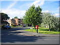
Life in B90 1AN offers a blend of convenience and local character. Residents can access five retail outlets, including Asda Solihull New and Sainsburys Solihull Haslucks, for everyday shopping needs. The area’s transport links are strong, with five railway stations and metro stops providing easy access to Birmingham and surrounding areas. For leisure, the nearby Transport Museum Wythall, housed in a former RAF site, offers a unique cultural attraction. While the area itself is small, its proximity to larger towns means residents can enjoy a wider range of dining, entertainment, and recreational facilities. The presence of multiple rail and metro connections also supports a lifestyle that balances local simplicity with urban connectivity. This makes B90 1AN suitable for those who value a quiet, residential environment without sacrificing access to broader opportunities.
Amenities
Schools
| Rank | School | Type | Entry gender | Ages |
|---|
Explore more schools in this area
Go to Schools tabDemographics
The population of B90 1AN is predominantly adults aged 30–64, with a median age of 47. This suggests a mature, settled community where most residents are likely in their prime working years or nearing retirement. Home ownership is exceptionally high at 91%, indicating a strong preference for long-term residency over rental properties. The accommodation type is primarily houses, reflecting a suburban or semi-rural character rather than high-rise or apartment living. The predominant ethnic group is White, though no specific data on diversity or deprivation levels is provided. This demographic profile points to a stable, family-oriented environment where residents are likely to have established careers and local ties. The age range also implies a community with a mix of active professionals and retirees, contributing to a balanced social dynamic.
Household Size
Accommodation Type
Tenure
Ethnic Group
Religion
Household Composition
Age
Household Deprivation
NS-SEC
Explore more demographic insights in this area
Go to Demographics tabPlanning
Planning Constraints
- Flood RiskPremium
- Ramsar Wetland SitesPremium
- Area of Outstanding Natural BeautyPremium
- Protected Nature ReservePremium
- Protected WoodlandPremium