Area Overview for B8 3PU
Photos of B8 3PU
Area Information
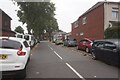
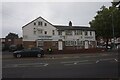
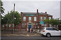
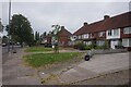
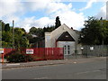
Living in B8 3PU, part of the Alum Rock area in Birmingham, means inhabiting a densely populated inner-city suburb with a distinct character. This postcode covers a small residential cluster within the broader Saltley region, centred around Alum Rock Road. With a population of 2,025, it is a compact community situated approximately 2 miles east of Birmingham city centre. The area’s history traces back to the 18th century, when it was named for alum-bearing rock used in leather tanning. Today, it is a diverse and youthful neighbourhood, with a median age of 22 and a significant proportion of residents aged 30–64. Daily life here is shaped by its proximity to transport hubs, retail outlets, and local schools, though the area is described as deprived, with high levels of deprivation influencing employment and educational outcomes. Despite this, B8 3PU offers a blend of urban convenience and community ties, with amenities like Iceland, M&S, and Aldi within practical reach. Its compact size and connectivity make it a practical choice for those seeking a balance between city access and residential living.
- Area Type
- Postcode
- Area Size
- Not available
- Population
- 2025
- Population Density
- 9859 people/km²
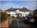
The property market in B8 3PU reflects a mix of owner-occupation and rental activity, with 54% of homes owned by residents. The accommodation type is predominantly houses, which is unusual for an inner-city area but suggests a focus on family-sized properties. This contrasts with the high population density, implying that homes may be smaller or multi-occupied. The area’s small size means the housing stock is concentrated, with limited scope for expansion. For buyers, this presents a challenge: while the presence of houses may appeal to families, the high deprivation and lower employment rates could affect long-term investment potential. The immediate surroundings also lack major commercial or industrial employers, which might influence property values. However, proximity to transport links like Stechford and Adderley Park railway stations could offset some of these factors. Buyers should consider the area’s demographic trends, including a youthful population and high BAME representation, which may influence local demand and community dynamics.
House Prices in B8 3PU
No properties found in this postcode.
Energy Efficiency in B8 3PU
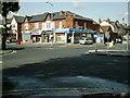
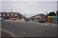
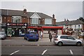
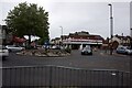
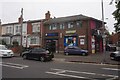
Life in B8 3PU is shaped by its proximity to retail, transport, and local institutions. The area’s retail scene includes Iceland, M&S Birmingham, and Aldi, offering everyday shopping needs within walking distance. Alum Rock Road, known locally as “The Rock,” is a 3 km shopping corridor, though specific stores within the postcode are limited. Transport links are a key feature, with five railway stations and five metro stops providing easy access to Birmingham’s business districts and cultural hubs. For leisure, the area is home to Alum Rock FC, a local football club competing in the South Birmingham Football League, and the Grade II listed Brookhill Tavern pub. Schools like Washwood Heath Academy and Eden Boys’ Leadership Academy cater to the community’s educational needs. While green spaces are not explicitly mentioned, the absence of protected nature reserves or AONB coverage suggests limited natural amenities. The lifestyle here is practical and community-focused, with daily life revolving around local shops, transport, and schools, though the area’s deprived status may limit access to higher-end services.
Amenities
Schools
| Rank | School | Type | Entry gender | Ages |
|---|
Explore more schools in this area
Go to Schools tabDemographics
The community in B8 3PU is predominantly young, with a median age of 22 and the most common age range being adults aged 30–64. Home ownership stands at 54%, indicating a mix of owner-occupied and rental properties. The area is characterised by houses as the primary accommodation type, though the high population density suggests a compact, urban layout. Ethnically, the predominant group is Asian, with the broader area having a 93.6% BAME population. This reflects a diverse demographic profile, though the area is also marked by deprivation, which correlates with lower employment rates and higher claimant count unemployment. The younger age profile and high proportion of working-age residents without qualifications suggest a community with evolving needs, particularly in education and job training. Despite this, the presence of schools like Washwood Heath Academy and Eden Boys’ Leadership Academy indicates efforts to support local development. The combination of youth, diversity, and deprivation shapes a unique social fabric, with a focus on community resilience.
Household Size
Accommodation Type
Tenure
Ethnic Group
Religion
Household Composition
Age
Household Deprivation
NS-SEC
Explore more demographic insights in this area
Go to Demographics tabPlanning
Planning Constraints
- Flood RiskPremium
- Ramsar Wetland SitesPremium
- Area of Outstanding Natural BeautyPremium
- Protected Nature ReservePremium
- Protected WoodlandPremium