Area Overview for B8 2XX
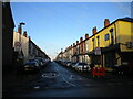
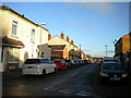
Photos of B8 2XX

Area Information
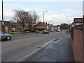
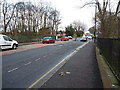
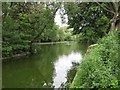
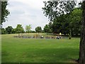
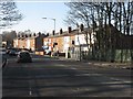
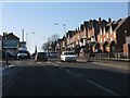
Living in B8 2XX, a small residential cluster in Birmingham’s east, means inhabiting a densely populated area with a distinct urban character. The postcode covers 4,479 square metres, housing 1,811 residents in a compact layout. Situated between Saltley, Hodge Hill, Stechford, and Washwood Heath, it blends historical roots with modern living. Ward End, the area’s core, retains echoes of its 19th-century origins, including Ward End Park, which opened in 1904 and features the historic Ward End House. Daily life here balances proximity to amenities with a sense of community. The area’s compact size ensures residents are within walking distance of shops, transport hubs, and green spaces. With a median age of 22 and a majority of residents aged 30–64, the community reflects a mix of young professionals and families. The high population density—404,351 people per square kilometre—creates a lively, tightly knit environment, though it also underscores the area’s urban intensity.
- Area Type
- Postcode
- Area Size
- 4479 m²
- Population
- 1811
- Population Density
- 11390 people/km²
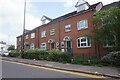
The property market in B8 2XX is defined by a 43% home ownership rate, suggesting a rental market dominates. The area’s accommodation type is primarily houses, which is unusual in modern Birmingham, where flats are more common. This mix of housing stock may appeal to buyers seeking larger properties, though the small size of the postcode means the available stock is limited. Proximity to transport links, schools, and amenities like Ward End Park adds value. However, buyers should consider the area’s density and the need to look beyond B8 2XX for more extensive housing options. The presence of houses may also indicate a focus on family homes, though the lower home ownership rate suggests many residents rent, possibly due to affordability or lifestyle choices.
House Prices in B8 2XX
Showing 1 properties
| Address | Type | Beds | Baths | Last Sale Price | Last Sale Date | |
|---|---|---|---|---|---|---|
| 295 Washwood Heath Road, Birmingham, B8 2XX | office_workshop | - | - | - | - |
Energy Efficiency in B8 2XX
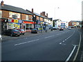
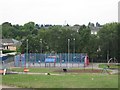
Life in B8 2XX is shaped by its proximity to a variety of amenities. Residents can access retail hubs such as Costco Birmingham, Asda Armada, and Iceland Washwood, making daily shopping convenient. The area’s transport links—rail and metro stations—connect it to Birmingham’s broader network, facilitating travel to work, schools, or leisure spots. Ward End Park offers a green space for relaxation, exercise, or family activities, complementing the urban environment. The park’s historic Ward End House adds a touch of heritage to the area’s leisure options. While the data does not specify dining or entertainment venues, the presence of multiple retail and transport options suggests a lifestyle that balances practicality with accessibility. The compact layout ensures residents can reach amenities quickly, though the area’s density may mean shared spaces are in frequent use.
Amenities
Schools
Residents of B8 2XX have access to Highfield Junior and Infant School, a primary school rated ‘good’ by Ofsted. This school serves both the primary and academy sectors, offering families a range of educational options. The presence of a rated ‘good’ school is a significant draw for families, ensuring quality education within walking distance. The school’s dual role as a primary and academy suggests it may cater to a broad age range, reducing the need for parents to seek multiple institutions. For families prioritising education, this school’s proximity and rating provide reassurance. However, the data does not mention secondary schools, so buyers should investigate further if they require additional educational facilities.
| Rank | School | Type | Entry gender | Ages |
|---|
Explore more schools in this area
Go to Schools tabDemographics
B8 2XX has a median age of 22, but the most common age range among residents is 30–64 years, indicating a strong presence of working-age adults. Home ownership stands at 43%, suggesting a significant proportion of residents rent their homes. The area is predominantly composed of houses, which contrasts with the higher proportion of flats in other parts of Birmingham. The predominant ethnic group is Asian_total, reflecting the area’s cultural diversity. This demographic profile shapes a community where families and professionals coexist. The high population density—404,351 people per square kilometre—means shared spaces and services are in constant use. While the data does not specify deprivation levels, the mix of age groups and housing types implies a varied socioeconomic landscape, with both established residents and newer arrivals contributing to the area’s dynamic character.
Household Size
Accommodation Type
Tenure
Ethnic Group
Religion
Household Composition
Age
Household Deprivation
NS-SEC
Explore more demographic insights in this area
Go to Demographics tabPlanning
Planning Constraints
- Flood RiskPremium
- Ramsar Wetland SitesPremium
- Area of Outstanding Natural BeautyPremium
- Protected Nature ReservePremium
- Protected WoodlandPremium