Area Overview for B8 2WA
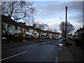
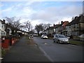
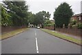
Photos of B8 2WA
Area Information
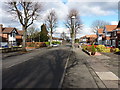
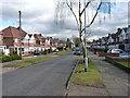
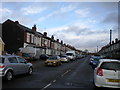
Living in B8 2WA means being part of a compact, residential cluster in Birmingham’s east, nestled between Saltley, Hodge Hill, and Washwood Heath. With a population of 2,752, this area balances urban convenience with historical roots. Ward End, the local ward, traces its origins to an 1841 ecclesiastical parish, and its legacy persists in landmarks like Ward End Park, which opened in 1904. The area’s character is defined by its proximity to green spaces, such as the historic Ward End House, and its integration into Birmingham’s transport network. Daily life here is shaped by a mix of local amenities, including shops, rail links, and community hubs. The area’s small size means residents often know their neighbours, while its location offers easy access to nearby towns and services. For those seeking a blend of urban and semi-rural living, B8 2WA provides a distinct microcosm of Birmingham’s evolving landscape.
- Area Type
- Postcode
- Area Size
- Not available
- Population
- 2752
- Population Density
- 10856 people/km²
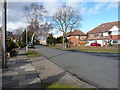
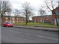
The property market in B8 2WA is characterised by a 66% home ownership rate, with houses being the primary accommodation type. This indicates a community where owner-occupation is prevalent, though rental options likely exist to complement the demand. The area’s small size means the housing stock is limited, with properties concentrated in a compact cluster. The prevalence of houses, rather than apartments or flats, suggests a focus on family-friendly living, with larger homes and garden spaces. For buyers, this presents both opportunities and challenges: the limited supply may drive competition, but the presence of houses could appeal to those seeking space and privacy. Proximity to transport links and amenities also enhances the area’s appeal, though its small footprint means buyers must consider proximity to larger urban centres for additional services. The market’s stability is reflected in the absence of major planning constraints, allowing for straightforward property transactions.
House Prices in B8 2WA
No properties found in this postcode.
Energy Efficiency in B8 2WA
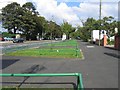
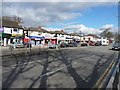
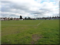
Life in B8 2WA is enriched by a range of nearby amenities, from retail to leisure. Local shops such as Iceland, Tesco, and Aldi provide everyday essentials, while rail and metro stations offer seamless access to Birmingham’s broader transport network. Ward End Park, a public space open for over a century, is a focal point for recreation, featuring the historic Ward End House. The park’s presence adds a green dimension to daily life, offering walking, relaxation, and community events. The area’s proximity to Bull Street and Corporation Street metro stops enhances connectivity, enabling quick trips to cultural or commercial hubs. While the small postcode limits the density of amenities, the combination of green space, shopping, and transport links creates a convenient, balanced lifestyle. For residents, the mix of urban infrastructure and accessible nature reflects a thoughtful blend of practicality and quality of life.
Amenities
Schools
The nearest school to B8 2WA is Ward End Community College, an independent institution. While no Ofsted rating is provided, the presence of an independent school suggests a focus on private education, which may cater to families seeking alternative schooling options. Independent schools often offer smaller class sizes, specialised curricula, or distinct pedagogical approaches compared to state schools. However, the area’s proximity to other parts of Birmingham means families could also access state schools in nearby wards. The mix of school types—though limited to one listed—reflects the area’s diversity in educational provision. For parents prioritising independent education, Ward End Community College is a key local resource, but those seeking state-funded options may need to look beyond the immediate postcode. The absence of additional schools in the data highlights the need for further research into nearby educational opportunities.
| Rank | School | Type | Entry gender | Ages |
|---|
Explore more schools in this area
Go to Schools tabDemographics
B8 2WA has a median age of 22, but the most common age range among residents is 30–64 years, suggesting a community skewed toward middle-aged adults. Home ownership stands at 66%, with houses being the predominant accommodation type. The area’s demographic profile is marked by a significant Asian population, reflecting broader trends in Birmingham’s diversity. This mix influences the local culture, with a range of community activities and services catering to varied needs. The relatively low population—2,752 people—means the area is neither densely packed nor isolated, offering a manageable scale for social interaction. While no deprivation data is provided, the presence of independent schools and accessible amenities indicates a baseline of infrastructure supporting daily life. The age distribution suggests a stable population, with families and professionals coexisting in a setting that prioritises housing over high-density living.
Household Size
Accommodation Type
Tenure
Ethnic Group
Religion
Household Composition
Age
Household Deprivation
NS-SEC
Explore more demographic insights in this area
Go to Demographics tabPlanning
Planning Constraints
- Flood RiskPremium
- Ramsar Wetland SitesPremium
- Area of Outstanding Natural BeautyPremium
- Protected Nature ReservePremium
- Protected WoodlandPremium