Area Overview for B8 2RD
Photos of B8 2RD

Area Information
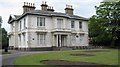
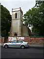
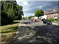
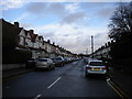
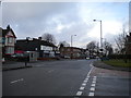
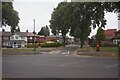
B8 2RD is a small, residential postcode cluster in Birmingham’s east, nestled between Saltley, Hodge Hill, Stechford, and Washwood Heath. With a population of 2,092, it is a compact area shaped by its historical roots as part of the ancient parish of Aston juxta Birmingham. The Ward End district, which includes this postcode, is defined by its proximity to Ward End Park and the historic Ward End House, a 19th-century structure with Victorian additions. Daily life here is characterised by a mix of urban convenience and green spaces, with the park offering a long-standing public amenity. The area’s compact nature means residents are within easy reach of nearby towns and transport hubs, though its small size means the local community is tightly knit. The postcode’s location in Birmingham’s West Midlands region positions it near major roads and rail links, facilitating both local and regional connectivity. For those seeking a blend of residential tranquillity and urban accessibility, B8 2RD offers a distinct microcosm of the city’s evolving landscape.
- Area Type
- Postcode
- Area Size
- Not available
- Population
- 2092
- Population Density
- 8702 people/km²
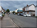
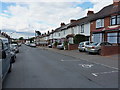
The property market in B8 2RD is dominated by owner-occupied homes, with 56% of properties owned by residents rather than rented. This suggests a stable, long-term community rather than a transient rental market. The accommodation type is predominantly houses, which is unusual for inner-city areas and may appeal to those seeking more space or a traditional home environment. Given the small size of the postcode area, the housing stock is likely limited, meaning buyers may need to consider nearby districts for additional options. The presence of houses rather than flats or apartments could indicate a focus on family-oriented living. However, the exact condition, price range, or recent trends in property values are not specified, so buyers should conduct further local inquiries. The mix of home ownership and house types positions B8 2RD as a niche area for those prioritising stability and space over high-density living.
House Prices in B8 2RD
No properties found in this postcode.
Energy Efficiency in B8 2RD
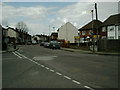
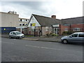
Living in B8 2RD offers access to a range of practical amenities within walking or short driving distance. The retail scene includes supermarkets such as Iceland Washwood, Tesco Hodge, and Aldi Hodge, providing everyday shopping convenience. Public transport is robust, with rail stations like Stechford and Adderley Park, and metro stops at Bull Street and St Chads, ensuring easy movement around the city. Ward End Park, a historic green space open for over a century, is a focal point for leisure, featuring the Ward End House, a 19th-century building with Victorian additions. The park’s long-standing presence adds a sense of continuity to the area’s character. While the data does not mention dining or cultural venues, the proximity to Birmingham’s broader urban offerings suggests a variety of options are accessible. The combination of green space, retail, and transport links creates a lifestyle that balances urban efficiency with local charm.
Amenities
Schools
| Rank | School | Type | Entry gender | Ages |
|---|
Explore more schools in this area
Go to Schools tabDemographics
The population of B8 2RD is 2,092, with a median age of 22, though the most common age range is adults aged 30–64, indicating a mix of younger and middle-aged residents. Home ownership here stands at 56%, suggesting a stable, owner-occupied community. The predominant accommodation type is houses, which is uncommon in many urban areas, reflecting a more traditional housing stock. The predominant ethnic group is Asian, highlighting the area’s cultural diversity. This demographic profile means the community is likely to have a strong sense of shared identity, with families and professionals coexisting. The age distribution suggests a balance between younger households and those in their prime working years, which may influence local services and amenities. However, the lack of specific data on deprivation means quality of life factors such as access to healthcare or education cannot be fully assessed from this information alone.
Household Size
Accommodation Type
Tenure
Ethnic Group
Religion
Household Composition
Age
Household Deprivation
NS-SEC
Explore more demographic insights in this area
Go to Demographics tabPlanning
Planning Constraints
- Flood RiskPremium
- Ramsar Wetland SitesPremium
- Area of Outstanding Natural BeautyPremium
- Protected Nature ReservePremium
- Protected WoodlandPremium