Area Overview for B79 7SY
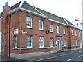
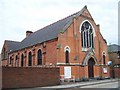
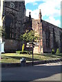
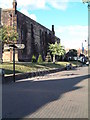
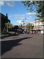
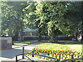
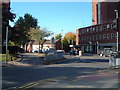
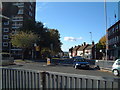
Photos of B79 7SY


Area Information
B79 7SY is a small residential postcode area in the Borough of Tamworth, Staffordshire, home to 2,159 residents. Nestled within Spital Ward, it lies at the coordinates 52.636113, -1.703172, blending quiet domesticity with proximity to local services. The area’s character is defined by its modest scale and historic touches, such as the Grade II listed milestone near Tamworth. Daily life here is shaped by a mix of family-oriented living and practical amenities, with residents benefiting from nearby schools, transport links, and retail options. While not a sprawling suburb, B79 7SY offers a compact, self-contained environment where community needs are met within walking or short-vehicle distance. Its location in the West Midlands region places it within reach of larger cities like Birmingham and Leicester, yet it retains a distinct local identity. The area’s appeal lies in its balance of accessibility and tranquility, making it suitable for those seeking a stable, family-focused environment without the bustle of urban centres.
- Area Type
- Postcode
- Area Size
- Not available
- Population
- 2159
- Population Density
- 3797 people/km²
B79 7SY is predominantly a housing area, with 55% of properties owned by residents rather than rented. The accommodation type is largely houses, which suggests a focus on family homes and semi-detached or detached properties. This contrasts with areas dominated by flats or apartments, where rental markets often prevail. The small size of the postcode area means the property stock is limited, and buyers may need to look beyond B79 7SY itself to find a broader range of options. The high proportion of owner-occupied homes indicates a community with long-term residency, potentially leading to stable property values. However, the lack of specific data on property prices or recent transactions means the market’s dynamics remain unclear. For buyers, the area’s compact nature means proximity to amenities and transport is a key consideration, though the immediate surroundings may offer more variety.
House Prices in B79 7SY
No properties found in this postcode.
Energy Efficiency in B79 7SY
The lifestyle in B79 7SY is shaped by its proximity to practical amenities, including retail, dining, and transport hubs. Local shops such as Spar, Farmfoods Leyfields, and Tamworth Co-operative Society Co provide everyday essentials, reducing the need for long trips. The area’s rail and bus links ensure access to broader services, while the presence of multiple railway stations enhances connectivity. Though no specific parks or leisure facilities are listed, the nearby Grade II listed milestone hints at a heritage-rich environment. The community’s character is defined by its quiet, residential nature, with amenities tailored to daily living rather than large-scale leisure. For residents, the balance of convenience and tranquility makes B79 7SY a practical choice, though those seeking extensive recreational options may need to look beyond the immediate area.
Amenities
Schools
Residents of B79 7SY have access to a range of educational institutions, including primary schools and sixth-form colleges. Moorgate Community Primary School and Marmion Junior School cater to younger children, while Tamworth and Lichfield College and Landau Forte Academy Tamworth Sixth Form provide post-16 education. Moorgate Primary Academy, a primary school with an Ofsted rating of ‘good’, adds to the area’s appeal for families. The mix of primary and sixth-form options suggests a comprehensive educational ecosystem, supporting children from early years through to higher education. However, the absence of secondary schools within the postcode means students may need to commute to nearby areas for secondary education. For families prioritising school proximity, the availability of multiple primary schools is a notable advantage, though the lack of a local secondary school could influence housing decisions.
| Rank | School | Type | Entry gender | Ages |
|---|
Explore more schools in this area
Go to Schools tabDemographics
The population of B79 7SY is 2,159, with a median age of 47, indicating a community skewed toward middle-aged adults. The most common age range is 30–64 years, suggesting a stable demographic with a strong presence of working-age residents. Home ownership stands at 55%, slightly above the national average, with houses being the predominant accommodation type. This points to a mix of owner-occupied properties and rentals, though the exact proportion of the latter is not specified. The predominant ethnic group is White, though no further breakdown of diversity is provided. The absence of detailed deprivation data means the area’s socioeconomic profile remains opaque, but the age range and home ownership figures imply a relatively settled population with established roots. For those considering relocation, the area’s demographic stability may offer a sense of continuity and community cohesion.
Household Size
Accommodation Type
Tenure
Ethnic Group
Religion
Household Composition
Age
Household Deprivation
NS-SEC
Explore more demographic insights in this area
Go to Demographics tabPlanning
Planning Constraints
- Flood RiskPremium
- Ramsar Wetland SitesPremium
- Area of Outstanding Natural BeautyPremium
- Protected Nature ReservePremium
- Protected WoodlandPremium