Area Overview for B79 0AN
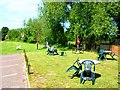
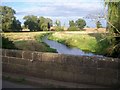
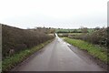
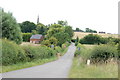
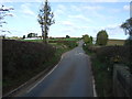
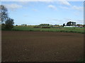
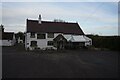
Photos of B79 0AN

Area Information
Living in B79 0AN, the postcode for Clifton Campville, offers a blend of rural tranquillity and historical depth. This small village in Staffordshire, near Lichfield, sits along the River Mease and has a population of around 2,019, with a low density of 48 people per square kilometre. The area retains its village character, with a history stretching back to the 10th century, including mentions in the Domesday Book and associations with the Norman de Camville family. St Andrew’s Church, a Grade II-listed building with medieval origins, and the Old Rectory, a 15th-century home, are among its notable landmarks. Daily life here is shaped by its rural setting, with a community rooted in tradition. The village is accessible via nearby rail stations in Tamworth and Polesworth, connecting residents to larger towns. While the population is modest, the area’s charm lies in its preserved heritage and peaceful environment, making it appealing to those seeking a slower pace of life without sacrificing proximity to urban amenities.
- Area Type
- Postcode
- Area Size
- Not available
- Population
- 2019
- Population Density
- 48 people/km²
The property market in B79 0AN is characterised by high home ownership, with 74% of residents owning their homes. The accommodation type is predominantly houses, indicating a focus on larger, family-friendly properties rather than flats or apartments. This suggests a market skewed towards owner-occupation, with limited rental availability. Given the small size of the area and its rural setting, the housing stock is likely to be limited in volume, with properties concentrated in a residential cluster. Buyers should consider the proximity to nearby towns like Tamworth, where additional options may be available. The predominance of houses may appeal to those seeking space and privacy, though the small postcode area means competition for properties could be fierce. For those prioritising a traditional village lifestyle with historical features, B79 0AN offers a niche market with distinct character.
House Prices in B79 0AN
No properties found in this postcode.
Energy Efficiency in B79 0AN
The lifestyle in B79 0AN is shaped by its rural setting and nearby amenities. Within practical reach are five retail outlets, including Tamworth Co-operative Society Co, Co-op Overseal, and Co-op Ashby, offering essential shopping. The village’s proximity to rail stations in Tamworth and Polesworth provides access to urban centres, while the Victoria Road Bus Interchange connects to local routes. Though the area itself is small, its location near the River Mease and historical sites like St Andrew’s Church adds to its charm. The limited number of amenities means residents may need to travel for specialist services, but the presence of multiple schools and transport links suggests a balance between village tranquillity and accessibility. This makes B79 0AN suitable for those seeking a self-contained lifestyle with easy access to nearby towns for additional needs.
Amenities
Schools
The schools near B79 0AN include four Church of England primary schools: St Andrew’s CofE (C) Primary School, Mary Howard CofE (VC) Primary School, St Andrew’s Church of England Primary School, and Mary Howard Church of England Primary School. These institutions serve the local community, offering primary education with a faith-based focus. The presence of multiple schools suggests a strong emphasis on education, though the data does not provide Ofsted ratings or academic performance details. Families may benefit from the variety of options, though the proximity of these schools to the village means they are likely to cater to local needs rather than offering specialist facilities. The mix of school names and types reflects a consistent educational provision, aligning with the area’s historical and religious heritage.
| Rank | School | Type | Entry gender | Ages |
|---|
Explore more schools in this area
Go to Schools tabDemographics
The community in B79 0AN is predominantly composed of adults aged 30–64, with a median age of 47. Home ownership is high, at 74%, reflecting a stable, long-term resident base. The accommodation type is primarily houses, suggesting a focus on family homes and larger properties. The predominant ethnic group is White, which aligns with the area’s historical and cultural continuity. The age profile indicates a mature population, which may influence local services and amenities. With 48 people per square kilometre, the area avoids the density of larger towns, contributing to a quieter, more spread-out lifestyle. This demographic profile suggests a community that values stability and familiarity, with fewer transient residents. The lack of specific data on deprivation means quality of life is inferred from the low population density and high home ownership, pointing to a generally secure and self-sufficient environment.
Household Size
Accommodation Type
Tenure
Ethnic Group
Religion
Household Composition
Age
Household Deprivation
NS-SEC
Explore more demographic insights in this area
Go to Demographics tabPlanning
Planning Constraints
- Flood RiskPremium
- Ramsar Wetland SitesPremium
- Area of Outstanding Natural BeautyPremium
- Protected Nature ReservePremium
- Protected WoodlandPremium