Area Overview for B77 2DT
Photos of B77 2DT


Area Information
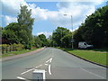
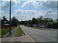
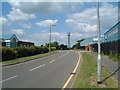
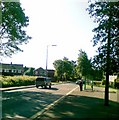
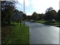
Living in B77 2DT, part of Glascote in Tamworth, Staffordshire, offers a blend of historical charm and practical modernity. This small residential cluster, with a population of 1,355, sits to the south-east of Tamworth town centre, bisected by Glascote Road. The area’s character is defined by its Victorian terrace houses in the oldest village core and post-1960s New Town-style architecture near Marlborough Way. Historically linked to 19th-century industry, including clay and coal production, the area now thrives as a quiet, low-density neighbourhood. Residents benefit from proximity to Tamworth’s amenities while retaining a distinct local identity. The postcode’s small size means a tight-knit community, with easy access to rail and bus networks. For those seeking a balance between tradition and convenience, B77 2DT provides a stable, family-oriented environment with a median age of 47 and a predominantly adult population. Its location on the edge of the West Midlands greenbelt ensures a peaceful setting, though it remains just 18 miles from Birmingham’s conurbation.
- Area Type
- Postcode
- Area Size
- Not available
- Population
- 1355
- Population Density
- 4741 people/km²
The property market in B77 2DT is characterised by a 42% home ownership rate, with houses forming the majority of the accommodation stock. This suggests a predominantly owner-occupied area, though the relatively low home ownership figure indicates a notable rental market. The housing stock includes Victorian terrace houses in the historic village core and post-1960s New Town-style developments near Marlborough Way. Given the small size of the postcode, property availability is limited, and buyers should consider nearby areas for more options. The mix of architectural styles offers a range of characterful homes, though the lack of high-rise or modern developments means the area remains low-density. For buyers, the focus on houses rather than flats or apartments may appeal to those prioritising space and traditional building styles. The market’s stability is supported by the area’s safety and connectivity, making it attractive to families and long-term residents.
House Prices in B77 2DT
No properties found in this postcode.
Energy Efficiency in B77 2DT
Residents of B77 2DT have access to a range of nearby amenities, including five retail outlets such as Spar and Morrisons Daily, ensuring convenience for daily shopping needs. The area’s transport links, including four railway stations and a bus interchange, provide easy access to Tamworth and beyond. While the data does not list parks or leisure facilities explicitly, the historical context of Glascote Road—a former toll road—suggests a connection to local green spaces. The presence of a primary school and the community’s small size foster a sense of cohesion. For daily life, the combination of retail options and transport connectivity offers practicality, though those seeking extensive leisure facilities may need to look further afield. The area’s blend of historical and modern elements contributes to a distinctive, low-key lifestyle.
Amenities
Schools
The nearest school to B77 2DT is Oakhill Primary School, a primary institution with a good Ofsted rating. This school serves the local community, providing education for younger children in the area. The presence of a primary school suggests that families with children are a significant part of the population, though no secondary schools are listed in the data. The good Ofsted rating indicates a reliable standard of education, which is a key consideration for homebuyers prioritising schools. The absence of secondary schools may influence decisions about proximity to larger educational institutions in Tamworth or surrounding areas. For parents, the quality of Oakhill Primary School offers reassurance about the area’s commitment to education, though further research would be needed for secondary schooling options.
| Rank | School | Type | Entry gender | Ages |
|---|
Explore more schools in this area
Go to Schools tabDemographics
The community in B77 2DT is predominantly composed of adults aged 30–64, with a median age of 47. Home ownership stands at 42%, indicating a mix of owner-occupied properties and rental stock. The area’s accommodation is primarily houses, reflecting a residential focus rather than high-density housing. The predominant ethnic group is White, though specific data on diversity beyond this is not provided. With a population of 1,355, the area is small enough to foster familiarity among residents. The lower home ownership rate suggests a proportion of the population may rent, potentially influencing the local rental market. The age profile indicates a stable demographic, with fewer young families or retirees compared to other areas. This balance may affect local services and amenities, though the presence of a primary school suggests some provision for younger residents.
Household Size
Accommodation Type
Tenure
Ethnic Group
Religion
Household Composition
Age
Household Deprivation
NS-SEC
Explore more demographic insights in this area
Go to Demographics tabPlanning
Planning Constraints
- Flood RiskPremium
- Ramsar Wetland SitesPremium
- Area of Outstanding Natural BeautyPremium
- Protected Nature ReservePremium
- Protected WoodlandPremium