Area Overview for B77 1PS
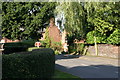
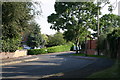
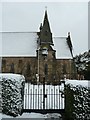
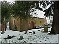
Photos of B77 1PS


Area Information
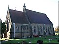
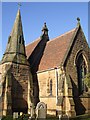
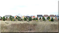
Living in B77 1PS means being part of a tightly knit residential cluster within Sutton Trinity, a suburban ward of Sutton Coldfield in Birmingham. The area’s population of 1,293 is spread across a compact footprint, with a density of 1,175 people per square kilometre, reflecting its small-scale, community-focused character. Sutton Trinity itself is a historically rooted area, named after Holy Trinity Parish Church, a Grade I listed building dating to the 13th century. Daily life here is defined by proximity to local amenities, including retail hubs like Tesco Dosthill and Lidl Tamworth, and easy access to rail networks. The area’s mix of older homes and suburban tranquillity appeals to those seeking a balance between convenience and a quieter lifestyle. With a median age of 47 and a population skewed toward adults aged 30–64, the community is stable and family-oriented, with 92% of residents owning their homes. This suggests a long-term presence of households, many of whom may have ties to the area’s history or local institutions.
- Area Type
- Postcode
- Area Size
- Not available
- Population
- 1293
- Population Density
- 1175 people/km²
The property market in B77 1PS is dominated by owner-occupied homes, with 92% of residents living in properties they own. This high rate of home ownership suggests a stable, long-term community with limited rental activity. The accommodation type is predominantly houses, which are more common than flats or apartments in this area. This indicates a housing stock that caters to families or individuals seeking larger living spaces, rather than younger professionals or students. For buyers, the small scale of the area means that properties are likely to be established and well-maintained, with limited new developments. The proximity to Sutton town centre and nearby rail stations may enhance the appeal of homes here, offering a blend of suburban comfort and access to urban amenities. However, the compact nature of the postcode means that buyers should consider the limited availability of properties and the potential for competition from existing residents.
House Prices in B77 1PS
No properties found in this postcode.
Energy Efficiency in B77 1PS
The lifestyle in B77 1PS is shaped by its proximity to local amenities and historical landmarks. Residents have access to five retail outlets, including Tesco Dosthill, Lidl Tamworth, and the Tamworth Co-operative Society, ensuring everyday shopping needs are met within reach. The area’s rail stations—Wilnecote, Tamworth High Level, and Polesworth—connect it to broader networks, while the Victoria Road Bus Interchange provides additional mobility. Beyond practicality, the presence of Holy Trinity Parish Church, a Grade I listed building, adds a sense of heritage and community identity. The suburban setting offers a quieter alternative to urban centres, with easy access to Sutton town centre for more extensive shopping or dining. This balance of local convenience and connectivity supports a lifestyle that is both self-sufficient and linked to regional opportunities.
Amenities
Schools
| Rank | School | Type | Entry gender | Ages |
|---|
Explore more schools in this area
Go to Schools tabDemographics
The demographic profile of B77 1PS is marked by a median age of 47, with the most common age range being adults aged 30–64. This suggests a mature, settled population, likely with established careers and family ties. Home ownership is exceptionally high at 92%, indicating a community of long-term residents rather than transient renters. The predominant accommodation type is houses, reflecting a residential area with larger properties rather than flats or apartments. The predominant ethnic group is White, which aligns with broader trends in the West Midlands. While no specific data on deprivation is provided, the high home ownership rate and stable age distribution imply a relatively affluent and secure community. The absence of significant demographic diversity data means the area’s cultural makeup remains less detailed, but the focus on family-oriented living and owner-occupied homes points to a cohesive, low-turnover environment.
Household Size
Accommodation Type
Tenure
Ethnic Group
Religion
Household Composition
Age
Household Deprivation
NS-SEC
Explore more demographic insights in this area
Go to Demographics tabPlanning
Planning Constraints
- Flood RiskPremium
- Ramsar Wetland SitesPremium
- Area of Outstanding Natural BeautyPremium
- Protected Nature ReservePremium
- Protected WoodlandPremium