Area Overview for B76 9PZ
Photos of B76 9PZ


Area Information
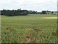
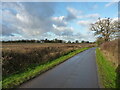
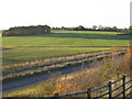
Living in B76 9PZ means being part of a small, closely knit residential cluster in England’s West Midlands. With a population of 1,619 spread over 17 km², the area has a low population density of 93 people per square kilometre, reflecting its rural character. Historically, the village of Wishaw, which includes this postcode, dates back to medieval times, with origins traced to the Domesday Book. The area is part of the Parish of Curdworth, Middleton and Wishaw, and retains a quiet, traditional feel. Daily life here is shaped by its proximity to nearby towns and the presence of local amenities like shops and rail links. The community is largely composed of adults aged 30–64, with a median age of 47, suggesting a stable, mature population. While the area lacks major urban infrastructure, its small size and low density offer a sense of privacy and connection to the surrounding landscape. Residents benefit from nearby rail stations and retail hubs, though the postcode’s isolation means it is best suited for those prioritising tranquillity over city-centre convenience.
- Area Type
- Postcode
- Area Size
- Not available
- Population
- 1619
- Population Density
- 93 people/km²
The property market in B76 9PZ is dominated by owner-occupied homes, with 87% of properties owned outright. This high rate of home ownership indicates a stable, long-term resident base rather than a rental-heavy market. The accommodation types are primarily houses, reflecting the area’s rural setting and low density. Given the small population and limited infrastructure, the housing stock is likely to be older, with many properties dating back to the area’s medieval origins. Buyers should expect a limited selection of properties, as the postcode covers only a small cluster of homes. The lack of commercial or industrial development means the area is unlikely to attract speculative investment. For those seeking a quiet, low-density environment, B76 9PZ offers a niche market, but its small size and lack of urban amenities may limit appeal to those needing proximity to city services.
House Prices in B76 9PZ
No properties found in this postcode.
Energy Efficiency in B76 9PZ
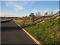
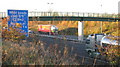
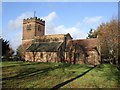
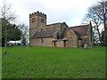
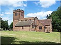
Residents of B76 9PZ have access to nearby amenities such as Tesco Water, Asda Minworth, and Asda Sutton, providing essential retail and grocery options. The area’s rail stations, including Water Orton and Sutton Coldfield, offer connections to larger towns and cities, though the postcode’s small size means these are the primary points of access. The historical Church of St. Chad, with medieval origins, adds cultural and architectural interest, while the Belfry golf course, once hosting the Ryder Cup, offers recreational opportunities. The lack of detailed data on parks or leisure facilities suggests a focus on nearby town amenities rather than local green spaces. The mix of retail, transport, and heritage sites creates a lifestyle that balances rural tranquillity with access to urban services, though the area’s small footprint means residents must plan for travel beyond the immediate vicinity.
Amenities
Schools
The nearest schools to B76 9PZ are both Curdworth Primary School, a primary school serving the local community. No secondary schools or Ofsted ratings are listed in the data, so details about higher education options are unavailable. The presence of a primary school suggests the area is suitable for families with young children, though parents may need to travel further for secondary schooling. The absence of additional educational institutions highlights the postcode’s small size and limited infrastructure. For families prioritising proximity to schools, Curdworth Primary School provides a local option, but broader educational needs may require commuting to nearby towns. The data does not indicate whether the school has recent performance ratings or facilities, so further research would be necessary for a full assessment.
| Rank | School | Type | Entry gender | Ages |
|---|
Explore more schools in this area
Go to Schools tabDemographics
The community in B76 9PZ is predominantly composed of adults aged 30–64, with a median age of 47. This suggests a mature, established population, likely with long-term ties to the area. Home ownership is high at 87%, indicating a strong presence of owner-occupied properties. The accommodation types are primarily houses, reflecting the area’s rural and semi-rural character. The predominant ethnic group is White, with no data provided on other demographics. The low population density of 93 people per km² further underscores the area’s sparse, spread-out nature. While no specific deprivation data is available, the high home ownership rate and stable age profile imply a relatively secure economic environment. However, the lack of detailed diversity metrics means the community’s full composition remains unclear. For buyers, this suggests a conservative, settled population with limited turnover in housing stock.
Household Size
Accommodation Type
Tenure
Ethnic Group
Religion
Household Composition
Age
Household Deprivation
NS-SEC
Explore more demographic insights in this area
Go to Demographics tabPlanning
Planning Constraints
- Flood RiskPremium
- Ramsar Wetland SitesPremium
- Area of Outstanding Natural BeautyPremium
- Protected Nature ReservePremium
- Protected WoodlandPremium