Area Overview for B76 9EW
Photos of B76 9EW


Area Information
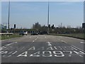
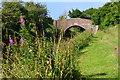
B76 9EW is a small residential postcode in North Warwickshire, situated between the M6 Toll and M42 motorways, close to Sutton Coldfield and Birmingham. With a population of 1,619 and a density of 93 people per square kilometre, it is a compact, tightly knit community. The area’s historical significance is evident, with Curdworth’s origins tracing back to the 6th or 7th centuries and its role as the site of the first skirmish of the English Civil War in 1642. The village is marked by its preserved heritage, including the Church of St Nicholas and Peter ad Vincula and its accolades as Best Kept Village in Warwickshire. Daily life here balances rural tranquillity with proximity to major transport routes, offering commuters easy access to Birmingham and surrounding areas. The area’s charm lies in its mix of historical sites, such as the moated Curdworth Hall, and modern amenities like retail outlets and railway stations. For those seeking a quiet yet connected lifestyle, B76 9EW combines heritage with practicality, making it a distinctive choice for homebuyers.
- Area Type
- Postcode
- Area Size
- Not available
- Population
- 1619
- Population Density
- 93 people/km²
B76 9EW is predominantly an owner-occupied area, with 87% of homes owned by residents rather than rented. The accommodation type is primarily houses, which is typical for smaller rural or semi-rural postcodes. This suggests a market characterised by larger properties, often with gardens, suited to families or individuals seeking space. Given the small size of the area, the housing stock is likely limited, making properties here more distinctive and potentially less competitive than in larger towns. Buyers should consider that the high home ownership rate may reduce rental availability, though the presence of nearby industrial estates and freight terminals could indicate some employment opportunities for local residents. For those prioritising property value stability, the low population density and historical appeal of the area may contribute to long-term retention of property values.
House Prices in B76 9EW
No properties found in this postcode.
Energy Efficiency in B76 9EW
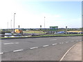
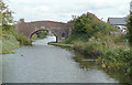
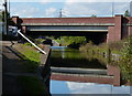
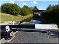
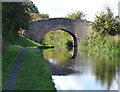
Living in B76 9EW offers a blend of historical charm and practical amenities. The King George V Playing Field, adjacent to the churchyard, provides recreational space, while the Birmingham and Fazeley Canal offers leisure opportunities. Retail options include Tesco and Asda outlets, and the nearby Hams Hall road freight terminal and Belfry Golf Course and Hotel add variety to the local landscape. The Church of St Nicholas and Peter ad Vincula, a historic landmark, contributes to the area’s character. Residents can access Birmingham International Airport and railway stations, enhancing connectivity. The small village feel is complemented by nearby industrial and commercial facilities, ensuring a balance between tranquillity and convenience. This mix supports both relaxed living and practical needs, appealing to those who value heritage alongside modern amenities.
Amenities
Schools
The nearest school to B76 9EW is Curdworth Primary School, a primary institution serving the local community. The data lists this school twice, but it is the only educational facility explicitly mentioned. As a primary school, it caters to children aged 4–11, though no secondary schools are noted in the area. Families with older children may need to look beyond B76 9EW for secondary education, potentially increasing travel time. The absence of additional schools suggests limited educational diversity, which could be a consideration for those prioritising a range of school options. However, the presence of a primary school indicates that basic educational needs are met locally, supporting families with younger children.
| Rank | School | Type | Entry gender | Ages |
|---|
Explore more schools in this area
Go to Schools tabDemographics
The population of B76 9EW is 1,619, with a median age of 47, indicating a community skewed towards middle-aged adults. The most common age range is 30–64 years, suggesting a stable demographic of working-age individuals and families. Home ownership is high at 87%, reflecting a predominantly owner-occupied area, while the accommodation type is primarily houses, implying larger properties rather than flats. The predominant ethnic group is White, with no specific data on other demographics. The age profile suggests a mature, established community, though the absence of younger residents may impact local schools and amenities. The low population density of 93 people per square kilometre indicates spacious living conditions, which align with the prevalence of houses. This profile points to a quiet, family-oriented environment with limited pressure on local services, though it may lack the diversity of larger urban areas.
Household Size
Accommodation Type
Tenure
Ethnic Group
Religion
Household Composition
Age
Household Deprivation
NS-SEC
Explore more demographic insights in this area
Go to Demographics tabPlanning
Planning Constraints
- Flood RiskPremium
- Ramsar Wetland SitesPremium
- Area of Outstanding Natural BeautyPremium
- Protected Nature ReservePremium
- Protected WoodlandPremium