Area Overview for B76 9DE
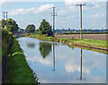
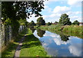
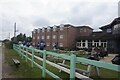
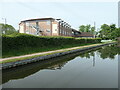
Photos of B76 9DE


Area Information
Living in B76 9DE means inhabiting a small, tightly knit residential cluster in England’s West Midlands. With a population of 1,476 and a density of 283 people per square kilometre, this postcode area is compact yet functional. The community is defined by its proximity to retail hubs, rail networks, and regional transport links, making it accessible to nearby cities and amenities. While the area lacks the historical grandeur of Sutton Coldfield—located in a different postcode—it benefits from a practical layout that prioritises connectivity. Residents here are likely to be middle-aged, given the median age of 47, and the area’s housing stock reflects a preference for owner-occupied properties. B76 9DE is not a sprawling suburb but a focused cluster, where daily life revolves around nearby shops, schools, and transport nodes. Its modest size means the character of the area is shaped by its immediate surroundings, with a balance of residential tranquility and urban convenience. For those seeking a place to settle without the sprawl of larger cities, B76 9DE offers a snapshot of suburban England, where practicality meets a manageable pace of life.
- Area Type
- Postcode
- Area Size
- Not available
- Population
- 1476
- Population Density
- 283 people/km²
The property market in B76 9DE is characterised by a strong emphasis on owner-occupied homes, with 64% of properties owned outright. This suggests a community where long-term residency is common, and the housing stock is primarily composed of houses rather than flats or apartments. Given the area’s small size and focus on residential clusters, the market is likely limited in scope, with few new developments. Buyers should consider that the availability of properties may be constrained by the area’s compact nature, necessitating a broader search in surrounding postcodes for more options. The dominance of houses implies a preference for family-friendly living, with larger homes and outdoor spaces. However, the lack of data on rental yields or property prices means the market’s financial dynamics remain opaque. For those prioritising ownership over investment, B76 9DE offers a stable, if modest, opportunity within a focused geographical footprint.
House Prices in B76 9DE
No properties found in this postcode.
Energy Efficiency in B76 9DE
Daily life in B76 9DE is shaped by its proximity to retail, rail, and regional transport hubs. Within walking or short driving distance are five retail outlets, including Asda Minworth and Tesco Water, offering groceries, clothing, and household goods. The area’s rail network includes five stations—Water Orton, Coleshill Parkway, and Chester Road—linking residents to nearby towns and cities. Birmingham International Airport and the Birmingham Intl Railway Station are also nearby, facilitating travel beyond the region. While the data does not mention parks or leisure facilities directly, the surrounding area’s historical context—such as Sutton Park in nearby postcodes—may provide recreational opportunities. The practical reach of amenities ensures that residents have access to essential services without needing to travel far. This balance of retail, transport, and connectivity contributes to a lifestyle that is both convenient and functional, ideal for those seeking a mix of suburban comfort and urban accessibility.
Amenities
Schools
The nearest school to B76 9DE is Minworth Junior and Infant School, a primary institution with an Ofsted rating of “good.” This school serves the area’s younger residents, providing education for children up to age 11. While no secondary schools are listed in the immediate vicinity, the presence of a well-rated primary school is a key consideration for families. The school’s “good” rating indicates a satisfactory standard of education, though parents may need to look beyond the postcode for secondary options. The absence of other schools in the data suggests that B76 9DE’s educational infrastructure is limited to primary-level provision. For families prioritising a strong foundation in early education, Minworth Junior and Infant School offers a reliable resource, but broader educational needs may require commuting to nearby towns or schools in adjacent areas.
| Rank | School | Type | Entry gender | Ages |
|---|
Explore more schools in this area
Go to Schools tabDemographics
The community in B76 9DE is predominantly middle-aged, with a median age of 47 and the largest age group being adults aged 30–64. This suggests a stable, established population, likely with long-term residency. Home ownership is high at 64%, indicating a strong presence of owner-occupied homes, though rental properties also exist. The accommodation type is primarily houses, which aligns with the area’s residential character. The predominant ethnic group is White, reflecting a homogenous demographic profile. While no data is provided on deprivation levels, the high home ownership and mature age profile suggest a community with relatively stable economic conditions. The absence of significant diversity metrics means the area’s social fabric is largely shaped by a single demographic group. For families or professionals seeking a settled environment, B76 9DE’s demographics offer a predictable, low-turnover community. However, the limited data on diversity and deprivation means broader social dynamics remain unexplored.
Household Size
Accommodation Type
Tenure
Ethnic Group
Religion
Household Composition
Age
Household Deprivation
NS-SEC
Explore more demographic insights in this area
Go to Demographics tabPlanning
Planning Constraints
- Flood RiskPremium
- Ramsar Wetland SitesPremium
- Area of Outstanding Natural BeautyPremium
- Protected Nature ReservePremium
- Protected WoodlandPremium