Area Overview for B75 6NW
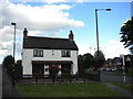
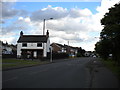
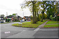
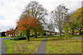
Photos of B75 6NW
Area Information
Living in B75 6NW means being part of a small, tightly knit residential cluster in England’s West Midlands. With a population of just 1,499, this postcode area reflects a quiet, stable community. Its proximity to Sutton Coldfield, a historic royal town absorbed into Birmingham in 1974, adds a layer of heritage to daily life. The area’s compact size fosters a sense of familiarity, with easy access to local amenities and transport links. Residents benefit from a mix of traditional and modern living, with homes primarily in private ownership and a median age of 47 suggesting a mature, settled population. The presence of nearby rail stations, such as Sutton Coldfield and Butlers Lane, ensures connectivity to surrounding cities, while the area’s low crime risk and flood-free status contribute to a secure environment. For those seeking a balance between tranquillity and accessibility, B75 6NW offers a glimpse into a bygone era of English town life, tempered by contemporary comforts.
- Area Type
- Postcode
- Area Size
- Not available
- Population
- 1499
- Population Density
- 2372 people/km²
The property market in B75 6NW is characterised by high home ownership (92%) and a predominance of houses, indicating a residential area where private ownership is the norm. This suggests a market skewed towards owner-occupied properties rather than rentals, which may limit availability for buyers seeking short-term or flexible housing solutions. The focus on houses, as opposed to flats or apartments, aligns with the area’s traditional character and appeal to families or those preferring larger living spaces. Given the small size of the postcode area, the housing stock is likely limited, meaning buyers should consider nearby zones for more options. The high home ownership rate also implies a low turnover of properties, potentially leading to a conservative market where prices may be stable but not rapidly appreciating. For those prioritising a settled, low-risk investment, B75 6NW offers a straightforward, predictable property landscape.
House Prices in B75 6NW
No properties found in this postcode.
Energy Efficiency in B75 6NW
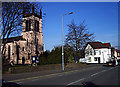
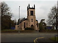
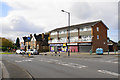
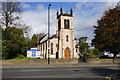
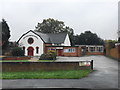
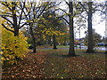
Life in B75 6NW is enriched by a mix of practical amenities and historical charm. Within practical reach are five retail outlets, including Morrisons Daily Sutton, Co-op Slade, and Sainsburys Mere, ensuring everyday shopping needs are met. The area’s rail network, with stations like Sutton Coldfield and Four Oaks, provides swift access to Birmingham’s cultural and commercial hubs. Nearby, Sutton Park—a medieval deer park with historical ties to Mercian royalty—offers green space for recreation, while Holy Trinity Church and Bishop Vesey’s Grammar School add a layer of heritage to daily life. The High Street conservation area preserves the town’s 16th-century character, with Archer marks on Coleshill Street hinting at its past as a military training ground. This blend of convenience, history, and natural beauty creates a lifestyle that balances modern practicality with a connection to the past.
Amenities
Schools
| Rank | School | Type | Entry gender | Ages |
|---|
Explore more schools in this area
Go to Schools tabDemographics
The community in B75 6NW is predominantly middle-aged, with a median age of 47 and the most common age range being 30–64 years. This suggests a population largely composed of working-age adults and retirees, contributing to a stable, low-turnover neighbourhood. Home ownership is exceptionally high at 92%, indicating a strong preference for long-term residency over rental properties. The accommodation type is primarily houses, reflecting a traditional, family-oriented housing stock. The predominant ethnic group is White, which aligns with broader demographic trends in the West Midlands. The absence of specific data on deprivation means the area’s quality of life cannot be assessed in that regard, but the high home ownership and age profile suggest a community focused on stability and continuity. This demographic profile shapes a local environment where familiarity and neighbourly ties are likely to be strong.
Household Size
Accommodation Type
Tenure
Ethnic Group
Religion
Household Composition
Age
Household Deprivation
NS-SEC
Explore more demographic insights in this area
Go to Demographics tabPlanning
Planning Constraints
- Flood RiskPremium
- Ramsar Wetland SitesPremium
- Area of Outstanding Natural BeautyPremium
- Protected Nature ReservePremium
- Protected WoodlandPremium