Area Overview for B74 2JS
Photos of B74 2JS

Area Information
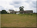
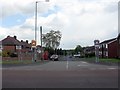
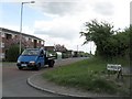
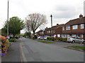
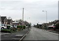
Living in B74 2JS means inhabiting a small, tightly knit residential cluster in the West Midlands, where semi-rural charm meets suburban convenience. With a population of 1,863, this area is part of the broader Streetly district, a historically rural region transformed by post-war housing developments. Nestled near Sutton Park, it retains pockets of open space and green belt land, offering a quieter alternative to Birmingham’s urban sprawl. The area’s proximity to New Oscott, Great Barr, and Little Aston ensures easy access to larger towns while maintaining a distinct identity. Residents benefit from a mix of modern housing built from the 1960s onward, with many properties privately owned. The area’s character is shaped by its Roman heritage, with Ryknield Street still visible in Sutton Park, and its railway history, marked by the closure of Streetly Station in 1965. Today, B74 2JS is a stable, low-density community where daily life revolves around local amenities, green spaces, and a strong sense of place.
- Area Type
- Postcode
- Area Size
- Not available
- Population
- 1863
- Population Density
- 5697 people/km²
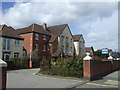
B74 2JS is a predominantly owner-occupied area, with 89% of homes privately owned. The accommodation type is exclusively houses, reflecting a lack of high-density housing or flats in this small postcode. This suggests a market skewed toward family homes and long-term residency rather than rental properties. The area’s housing stock, largely built from the 1960s onward, is modern by local standards but may lack the architectural diversity found in older suburbs. Given the small size of the postcode, the property market is likely limited to a few hundred homes, meaning buyers should consider nearby areas like Great Barr or Sutton Coldfield for broader options. The high home ownership rate indicates strong community stability, though the absence of rental data means the area’s appeal to investors remains unclear.
House Prices in B74 2JS
No properties found in this postcode.
Energy Efficiency in B74 2JS
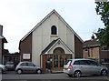
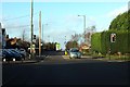
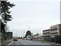
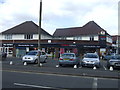
Residents of B74 2JS have access to a range of local amenities within practical reach. Retail options include Tesco Streetly, Waitrose Little, and M&S Foley BP, catering to everyday shopping needs. The area’s transport links connect it to nearby towns, while Sutton Park offers a major green space with a dedicated gate for residents. The park’s historical significance, including its Roman road connections, adds cultural value. Locally, the Parson & Clerk Inn marks the start of Ryknield Street, a historic landmark. The district’s semi-rural character means open spaces and farms remain accessible, though the proximity to modern housing ensures convenience. For leisure, the nearby libraries, clinics, and churches reflect the area’s community-focused infrastructure. This blend of practical amenities and natural surroundings supports a lifestyle that balances suburban comfort with access to nature.
Amenities
Schools
| Rank | School | Type | Entry gender | Ages |
|---|
Explore more schools in this area
Go to Schools tabDemographics
The population of B74 2JS is 1,863, with a median age of 47, reflecting a mature demographic skewed toward adults aged 30–64. Home ownership is exceptionally high at 89%, indicating a community of long-term residents rather than transient renters. The area is predominantly composed of houses, with no data suggesting the presence of flats or apartments. The predominant ethnic group is White, though no specific breakdown of diversity is provided. This age profile suggests a population focused on family life or retirement, with fewer young professionals or students. The high home ownership rate implies stable property values and a low turnover of residents, fostering a cohesive neighbourhood. However, the lack of data on deprivation or income levels means the area’s economic diversity remains unquantified.
Household Size
Accommodation Type
Tenure
Ethnic Group
Religion
Household Composition
Age
Household Deprivation
NS-SEC
Explore more demographic insights in this area
Go to Demographics tabPlanning
Planning Constraints
- Flood RiskPremium
- Ramsar Wetland SitesPremium
- Area of Outstanding Natural BeautyPremium
- Protected Nature ReservePremium
- Protected WoodlandPremium