Area Overview for B71 1DJ
Photos of B71 1DJ


Area Information
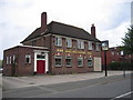
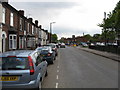
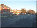
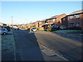
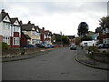
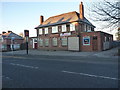
Living in B71 1DJ, part of Hateley Heath in West Bromwich, means being part of a compact residential cluster with a population of 1,953. This area, situated in the Metropolitan Borough of Sandwell, reflects a mix of post-war housing developments and recent community-driven improvements. Historically, it was shaped by mid-20th-century council housing, which still defines much of its character today. While the area faced challenges in the late 20th century, including high unemployment and crime, recent efforts have focused on safer streets and environmental upgrades. Residents here benefit from proximity to retail, transport, and schools, though the small scale of the postcode means the community feels closely knit. For those seeking a balance between urban convenience and a sense of local identity, B71 1DJ offers a practical base with straightforward access to essential services. Its location within West Bromwich ensures connectivity to broader regional networks, while its compact nature ensures a manageable, familiar environment for daily life.
- Area Type
- Postcode
- Area Size
- Not available
- Population
- 1953
- Population Density
- 5832 people/km²
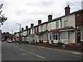
The property market in B71 1DJ is characterised by a 40% home ownership rate, with houses being the primary accommodation type. This suggests a rental-heavy market, where fewer properties are owner-occupied. Given the area’s history of council housing, many homes are likely older, post-war constructions, which may influence their condition and value. The small postcode area means the housing stock is limited, and buyers should consider the surrounding regions for more options. For those seeking a home, the predominance of houses could appeal to families, though the lower ownership rate might indicate a reliance on private rentals. Prospective buyers should also note the area’s compact nature, which may mean competition for available properties. The mix of housing types and ownership levels reflects a pragmatic, functional market rather than a high-end or speculative one.
House Prices in B71 1DJ
No properties found in this postcode.
Energy Efficiency in B71 1DJ
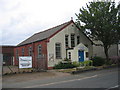
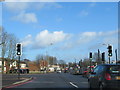
Daily life in B71 1DJ is supported by a range of nearby amenities, including five retail outlets such as Aldi Tildasley, Lidl West, and Co-op Hill, which provide grocery and household needs. The area’s five metro stops, including Black Lake and Dartmouth Street, offer quick access to local services, while three rail stations connect residents to broader destinations. These transport links, combined with retail options, create a functional lifestyle for residents. Though the area’s post-war housing character may lack green spaces, the presence of practical amenities ensures convenience for shopping, commuting, and daily routines. The compact nature of the postcode means amenities are closely grouped, reducing travel times. For those valuing accessibility over sprawling landscapes, B71 1DJ offers a straightforward, service-rich environment.
Amenities
Schools
The nearest school to B71 1DJ is All Saints CofE Primary School, which holds an Ofsted rating of “good.” This primary school serves the local community, offering education for younger children. The absence of secondary schools in the immediate vicinity means families may need to look beyond the postcode for comprehensive schooling. However, the presence of a well-rated primary school is a positive factor for those prioritising early education. The school’s rating indicates a satisfactory standard of teaching and facilities, though parents should consider the broader educational landscape when planning for long-term needs. For families with young children, the proximity of All Saints CofE Primary School offers convenience, but secondary education options would require additional travel.
| Rank | School | Type | Entry gender | Ages |
|---|
Explore more schools in this area
Go to Schools tabDemographics
The community in B71 1DJ is predominantly composed of adults aged 30–64, with a median age of 47. This suggests a mature population, likely with established careers and families. Home ownership here stands at 40%, indicating a higher proportion of rental properties compared to owner-occupied homes. The accommodation type is primarily houses, which is uncommon in many urban areas, reflecting a mix of older post-war housing stock. The predominant ethnic group is White, though no specific data on diversity beyond this is provided. The age profile and home ownership figures imply a stable, long-term resident base, though the 40% ownership rate may suggest limited opportunities for property investment. For those considering relocation, this demographic profile points to a community focused on practical living rather than rapid change or gentrification.
Household Size
Accommodation Type
Tenure
Ethnic Group
Religion
Household Composition
Age
Household Deprivation
NS-SEC
Explore more demographic insights in this area
Go to Demographics tabPlanning
Planning Constraints
- Flood RiskPremium
- Ramsar Wetland SitesPremium
- Area of Outstanding Natural BeautyPremium
- Protected Nature ReservePremium
- Protected WoodlandPremium