Area Overview for B70 9EE
Photos of B70 9EE


Area Information
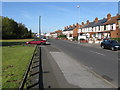
B70 9EE is a compact residential postcode nestled in the heart of West Bromwich, part of the Sandwell Metropolitan Borough. With a population of 2,068 and a density of 1,483 people per square kilometre, it reflects a tightly knit community shaped by interwar and post-war housing developments. The area blends older properties, some dating back to the early 20th century, with newer constructions, a result of ongoing regeneration efforts. Historically, it is tied to the industrial legacy of the Black Country, yet today it offers a mix of working-class character and community-driven renewal. The Lyng area, nearby, has seen significant redevelopment since the 1990s, introducing mixed-tenure housing and fostering a sense of local pride. Daily life here is grounded in proximity to essential services, with railway stations, retail hubs, and schools within walking distance. While the area retains a distinct working-class identity, its recent transformations suggest a balance between heritage and modernity, making it a place where history and practicality coexist.
- Area Type
- Postcode
- Area Size
- Not available
- Population
- 2068
- Population Density
- 1483 people/km²
The property market in B70 9EE is defined by a 51% home ownership rate, suggesting that nearly half of the housing stock is owner-occupied, while the remainder is likely rental properties. The area is predominantly composed of houses, which contrasts with higher-density housing typologies found in urban centres. This mix of private and council housing reflects a legacy of interwar and post-war development, with ongoing regeneration projects replacing older stock. For buyers, the small area’s limited size means housing options are concentrated, potentially increasing competition. The presence of both older and newer properties offers a range of choices, from historic homes to modern builds. However, the area’s working-class character and proximity to industrial infrastructure may influence property values. Investors should consider the balance between established housing and ongoing redevelopment, which could impact long-term stability and demand.
House Prices in B70 9EE
No properties found in this postcode.
Energy Efficiency in B70 9EE
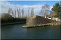
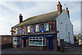
The lifestyle in B70 9EE is shaped by its proximity to a range of amenities within practical reach. Retail options include Asda Great, Heron Tipton, and Aldi Tildasley, offering everyday shopping needs. The area’s metro and rail networks provide access to Dudley Street Guns Village, Dartmouth Street, and Black Lake, which may include leisure or commercial spaces. Nearby railway stations such as Sandwell & Dudley and Tipton offer convenient transport links, while the Walsall Canal adds a scenic element to the local environment. Marl Hole Park, a former clay pit turned recreational space, is a notable feature, providing green space for relaxation. The mix of retail, transport, and natural amenities contributes to a practical, community-focused lifestyle. While the area’s working-class character may influence the variety of dining or entertainment options, the presence of these amenities ensures residents have access to essential services and recreational opportunities.
Amenities
Schools
The nearest school to B70 9EE is Newtown Primary School, a primary school with a Good Ofsted rating. This rating indicates that the school meets national standards for teaching quality, pupil outcomes, and leadership. As a primary school, it serves the local community’s youngest residents, offering a foundation for early education. The absence of secondary schools in the immediate vicinity means families may need to look beyond the postcode for secondary education, though nearby areas such as West Bromwich likely have options. The Good rating suggests a reliable educational environment, which is a key consideration for families prioritising school quality. The single listed school highlights the need for proximity to other educational institutions, but the existing rating provides reassurance for those seeking a solid primary education within the area.
| Rank | School | Type | Entry gender | Ages |
|---|
Explore more schools in this area
Go to Schools tabDemographics
The population of B70 9EE has a median age of 47, with the majority of residents aged between 30 and 64. This suggests a community skewed towards middle-aged adults, likely including families and professionals. Home ownership stands at 51%, indicating a mix of owner-occupied properties and rental stock. The predominant accommodation type is houses, reflecting a residential character that contrasts with high-density urban areas. The predominant ethnic group is White, though specific data on diversity is not provided. The age profile and home ownership rate imply a stable, long-term resident base, with fewer young families compared to areas with higher birth rates. The working-class feel, noted in local research, aligns with the presence of council housing and ongoing property demolitions. This demographic profile shapes a community focused on practical living, with a strong emphasis on local ties and established neighbourhoods.
Household Size
Accommodation Type
Tenure
Ethnic Group
Religion
Household Composition
Age
Household Deprivation
NS-SEC
Explore more demographic insights in this area
Go to Demographics tabPlanning
Planning Constraints
- Flood RiskPremium
- Ramsar Wetland SitesPremium
- Area of Outstanding Natural BeautyPremium
- Protected Nature ReservePremium
- Protected WoodlandPremium