Area Overview for B70 9DR
Photos of B70 9DR


Area Information
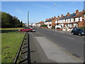
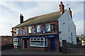
B70 9DR is a compact residential postcode area in England, covering 1.8 hectares and home to 2068 residents. With a population density of 1483 people per square kilometre, it reflects a tightly knit community. The area sits within the Greets Green and Lyng Ward, historically shaped by interwar and post-war housing developments between 1920 and 1970, blending older properties with newer builds. Its character is defined by a mix of private and council housing, some pre-First World War buildings, and ongoing regeneration. Lyng, in particular, has seen community-led redevelopment since the 1990s, introducing mixed-tenure housing and economic diversity. Despite pockets of deprivation, the area maintains strong social ties. Residents benefit from proximity to the Walsall Canal and Marl Hole Park, offering green space amid the urban fabric. The postcode is near West Bromwich, with railway stations like Sandwell & Dudley providing swift access to Birmingham. For buyers, B70 9DR offers a blend of affordability, historical charm, and practical connectivity, though its small size means limited housing stock.
- Area Type
- Postcode
- Area Size
- 1.8 hectares
- Population
- 2068
- Population Density
- 1483 people/km²
The property market in B70 9DR is dominated by houses, with 51% of residents owning their homes. This suggests a balance between owner-occupied properties and rental stock, though the small area size means limited housing availability. The presence of interwar and post-war housing, alongside some pre-First World War buildings, indicates a mix of older and newer homes. Regeneration efforts in Lyng have introduced mixed-tenure developments, but the overall stock remains rooted in mid-20th-century construction. For buyers, this means a focus on family-sized homes with potential for renovation or modernisation. The area’s compact nature means that proximity to amenities and transport is a key selling point. However, the high population density and ongoing housing demolitions may create competition for available properties. Buyers should consider the age of buildings and the need for maintenance, particularly in older stock. The market is likely to appeal to those seeking affordable housing in a connected urban setting.
House Prices in B70 9DR
Showing 2 properties
| Address | Type | Beds | Baths | Last Sale Price | Last Sale Date | |
|---|---|---|---|---|---|---|
| City Metal Recycling, Union Road, West Bromwich, B70 9DR | warehouse | - | - | - | - | |
| William King Limited, Atlas Centre, Union Road, West Bromwich, B70 9DR | Industrial | - | - | - | - |
Energy Efficiency in B70 9DR
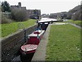
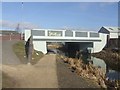
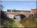
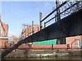
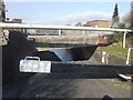
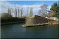
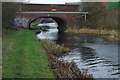
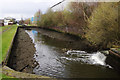
Residents of B70 9DR have access to a range of amenities within practical reach. Five rail stations, including Sandwell & Dudley and Dudley Port, provide easy access to Birmingham and surrounding areas. Metro stops such as Dudley Street Guns Village and Dartmouth Street offer additional transport options. Retail choices include Asda Great, Heron Tipton, and Aldi Tildasley, catering to everyday shopping needs. The Walsall Canal runs through the area, offering a scenic waterway for leisure. Marl Hole Park, a former clay pit, is a local green space for recreation. The area’s urban residential character is complemented by its proximity to historical sites like Oak House, a Grade II* listed building. These amenities contribute to a lifestyle that balances practicality with community engagement, though the compact nature of the area means residents must navigate limited space for expansion.
Amenities
Schools
The nearest school to B70 9DR is Newtown Primary School, a primary institution with an Ofsted rating of ‘good’. This school serves the local community, providing education for younger residents. The absence of secondary schools in the immediate vicinity means families may need to consider commuting for secondary education. The ‘good’ Ofsted rating indicates a satisfactory standard of teaching and facilities, though parents should verify if the school meets their specific needs. Given the area’s demographics, with a significant proportion of adults aged 30–64, the presence of a primary school supports families with young children. The lack of additional schools nearby may be a consideration for those prioritising a range of educational options. Overall, Newtown Primary School is a key local institution, reflecting the area’s focus on primary education.
| Rank | School | Type | Entry gender | Ages |
|---|
Explore more schools in this area
Go to Schools tabDemographics
The population of B70 9DR has a median age of 47, with the majority (30–64 years) falling into the adult working-age bracket. Home ownership stands at 51%, indicating a mix of owner-occupied and rental properties. The predominant accommodation type is houses, reflecting a residential focus rather than high-density living. The ethnic composition is overwhelmingly White, with no specific data on minority representation. The high population density of 1483 people per square kilometre suggests compact living conditions, which may impact quality of life for larger families. The age profile implies a community with a strong presence of middle-aged residents, potentially influencing local services and amenities. However, the working-class character of the area, combined with ongoing housing demolitions, points to some economic challenges. This demographic profile shapes a neighbourhood where community ties are central, but resources may be stretched by the need for infrastructure upgrades.
Household Size
Accommodation Type
Tenure
Ethnic Group
Religion
Household Composition
Age
Household Deprivation
NS-SEC
Explore more demographic insights in this area
Go to Demographics tabPlanning
Planning Constraints
- Flood RiskPremium
- Ramsar Wetland SitesPremium
- Area of Outstanding Natural BeautyPremium
- Protected Nature ReservePremium
- Protected WoodlandPremium