Area Overview for B70 7JJ
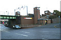
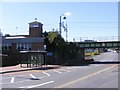
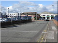
Photos of B70 7JJ


Area Information
Living in B70 7JJ means inhabiting a tightly packed residential cluster in Greets Green and Lyng Ward, part of Sandwell’s urban fabric. The area spans just 2.8 hectares, housing 1,979 residents in a density of 71,561 people per square kilometre. This compact postcode reflects the interwar and post-war housing developments that defined much of the Black Country’s residential landscape, with a smattering of pre-First World War buildings. The community is anchored by its historical ties to West Bromwich Albion Football Club, founded nearby in 1878, and features landmarks like the Grade II* listed Oak House. Daily life is shaped by a blend of older homes and ongoing regeneration, with a working-class character tempered by community-led efforts to modernise. Residents navigate a mix of council and private properties, often within walking distance of local amenities, while the area’s proximity to transport links and schools offers practical advantages. Despite its small size, B70 7JJ carries a distinct identity, rooted in its industrial past and evolving present.
- Area Type
- Postcode
- Area Size
- 2.8 hectares
- Population
- 1979
- Population Density
- 2092 people/km²
The property market in B70 7JJ is defined by a 54% home ownership rate, indicating a mix of owner-occupied and rental properties. The accommodation type is primarily houses, reflecting the area’s post-war housing developments and council-built stock. This suggests a focus on family homes rather than apartments or flats, which are less common. Given the postcode’s small size, the housing stock is limited, with regeneration efforts replacing older buildings. Buyers should consider the area’s compact nature, which may mean competition for available properties. The mix of private and council housing also implies a range of price points, though the working-class character of the area may influence affordability. For those seeking a traditional home in a historically significant part of West Bromwich, B70 7JJ offers a blend of established housing and ongoing redevelopment.
House Prices in B70 7JJ
No properties found in this postcode.
Energy Efficiency in B70 7JJ
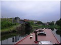
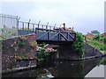
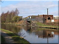
Residents of B70 7JJ enjoy a range of amenities within practical reach, including five retail spots like Sainsburys Oldbury and Iceland West, ensuring daily shopping convenience. Five metro stops, such as Lodge Road and Dartmouth Street, provide easy access to public transport, while five railway stations offer connections to Birmingham and beyond. The area’s proximity to Marl Hole Park, a former clay pit turned recreational space, adds greenery to urban living. The Walsall Canal, running through the district, offers a peaceful setting for leisure. These amenities, combined with the area’s compact size, create a lifestyle that balances practicality with small-town charm, allowing residents to access essentials without long commutes.
Amenities
Schools
Residents of B70 7JJ have access to two schools with good Ofsted ratings: Lyng Primary School, which serves younger children, and West Bromwich Collegiate Academy, a secondary institution. The presence of both a primary and an academy school provides families with options for education, though the mix suggests a focus on local, community-based learning. Lyng Primary’s proximity to the area’s residential cluster ensures ease of access for younger students, while the academy caters to older children. The good ratings indicate that both schools meet national standards in teaching and pupil outcomes. For families prioritising education quality, these institutions are a key advantage of living in B70 7JJ, offering stability and a range of academic opportunities.
| Rank | School | Type | Entry gender | Ages |
|---|
Explore more schools in this area
Go to Schools tabDemographics
The population of B70 7JJ skews towards adults aged 30–64, with a median age of 47. This suggests a community of established professionals and families, though the 54% home ownership rate indicates a significant portion of residents rent. The area’s housing stock is predominantly houses, reflecting a mix of private and council properties. The predominant ethnic group is Asian, contributing to a culturally diverse demographic. However, the working-class character of the area, noted in historical accounts, aligns with deprivation indicators evident in council housing and ongoing demolitions. This context shapes daily life, with a strong emphasis on community ties and local initiatives. The high population density, while practical for connectivity, may impact living space per household. For prospective buyers, understanding this balance between stability and urban density is key to assessing quality of life.
Household Size
Accommodation Type
Tenure
Ethnic Group
Religion
Household Composition
Age
Household Deprivation
NS-SEC
Explore more demographic insights in this area
Go to Demographics tabPlanning
Planning Constraints
- Flood RiskPremium
- Ramsar Wetland SitesPremium
- Area of Outstanding Natural BeautyPremium
- Protected Nature ReservePremium
- Protected WoodlandPremium