Area Overview for B70 0NR
Photos of B70 0NR


Area Information
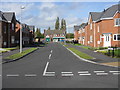
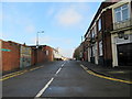
Living in B70 0NR means inhabiting a small, densely populated residential cluster in England’s West Midlands. With 2,068 residents spread across 2,000 square metres, the area has a high population density of 1,483 people per square kilometre. This postcode lies within Greets Green and Lyng Ward, historically shaped by interwar and post-war housing developments. The area blends older properties, some dating back to the pre-First World War era, with newer builds. It retains a working-class character, marked by council housing and ongoing regeneration efforts. Despite its compact size, B70 0NR offers a mix of community-driven spaces and practical amenities. Residents benefit from proximity to rail networks, retail hubs, and schools, though the area’s character is defined by its post-industrial Black Country surroundings and a legacy of slum clearance and redevelopment. The blend of older and newer housing, alongside community-led initiatives, creates a distinct local identity.
- Area Type
- Postcode
- Area Size
- 2000 m²
- Population
- 2068
- Population Density
- 1483 people/km²
The property market in B70 0NR is defined by a 51% home ownership rate, with houses making up the majority of accommodation types. This suggests a balance between owner-occupied properties and rental stock, though the area is not heavily reliant on the private rental sector. The housing stock reflects interwar and post-war developments, with a mix of private and council properties. Some older buildings remain, while newer constructions have emerged through regeneration projects. For buyers, this means a focus on standalone homes rather than apartments, with potential for both investment and long-term residency. The small area’s compact size means properties are likely to be close to local amenities, though the mix of housing types may present varied opportunities for buyers seeking specific property styles or conditions.
House Prices in B70 0NR
No properties found in this postcode.
Energy Efficiency in B70 0NR
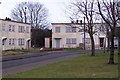
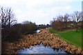
B70 0NR’s residents have access to a range of nearby amenities, including five metro stops such as Black Lake and Dudley Street Guns Village, offering transport links and community spaces. Retail options include Aldi Tildasley, Asda Great, and Lidl West, providing everyday shopping convenience. The area’s rail stations connect to broader networks, enhancing mobility. Locally, Marl Hole Park (colloquially known as “Marl ’ole”) offers green space, while the Walsall Canal adds a scenic element. The mix of retail, transport, and recreational facilities supports a practical, community-focused lifestyle. The presence of both historic and modern spaces, such as the Grade II* listed Oak House, adds to the area’s character. These amenities ensure daily life is accessible, though the compact size means residents may need to travel slightly further for specialist services.
Amenities
Schools
The nearest school to B70 0NR is Newtown Primary School, a primary school with an Ofsted rating of ‘good’. This provides a reliable educational option for families in the area. The presence of a primary school with a positive rating suggests accessible, quality early education for local children. However, the data does not mention secondary schools or other educational institutions nearby. Families requiring a broader range of schooling options may need to look beyond the immediate area. The availability of a rated primary school is a key consideration for homebuyers prioritising proximity to schools, though further research would be needed to assess secondary education options.
| Rank | School | Type | Entry gender | Ages |
|---|
Explore more schools in this area
Go to Schools tabDemographics
B70 0NR’s population of 2,068 is predominantly adults aged 30–64, with a median age of 47. This suggests a community focused on established households and families. Home ownership stands at 51%, indicating a mix of owner-occupied and rental properties. The area is characterised by houses rather than flats, reflecting a preference for standalone living. The predominant ethnic group is White, aligning with broader regional demographics. However, the area’s working-class feel and ongoing housing demolitions suggest some levels of deprivation, which may influence access to services or amenities. The age profile implies a need for community facilities catering to middle-aged residents, such as healthcare services or local clubs. The high population density also means shared spaces and resources are central to daily life.
Household Size
Accommodation Type
Tenure
Ethnic Group
Religion
Household Composition
Age
Household Deprivation
NS-SEC
Explore more demographic insights in this area
Go to Demographics tabPlanning
Planning Constraints
- Flood RiskPremium
- Ramsar Wetland SitesPremium
- Area of Outstanding Natural BeautyPremium
- Protected Nature ReservePremium
- Protected WoodlandPremium