Area Overview for B70 0DL
Photos of B70 0DL

Area Information
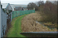
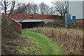
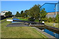
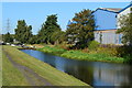
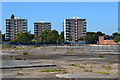
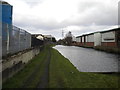
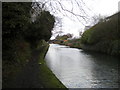
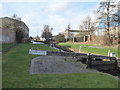
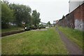
Living in B70 0DL, a small residential cluster in the West Midlands, means being part of a tightly knit community with a rich industrial heritage. The area, part of the historic village of Great Bridge in Sandwell, sits near Dudley, West Bromwich, and Wednesbury, with coordinates close to 52.53°N 2.03°W. Its name derives from a gravelly stream crossed by a bridge, a feature still evident in the local geography. The area’s compact size—home to 2068 people in a dense 1483 people/km²—reflects its character as a residential hub rather than a sprawling suburb. Daily life here is shaped by proximity to retail, transport, and green spaces, with the Walsall Canal and River Tame offering scenic routes. The 24-hour Asda superstore, opened in 1998 on a former factory site, remains a key landmark, while the Black Country Spine Road ensures quick access to nearby towns and motorways. This area blends historical roots with modern infrastructure, making it a pragmatic choice for those seeking a balance between community and connectivity.
- Area Type
- Postcode
- Area Size
- Not available
- Population
- 2068
- Population Density
- 1483 people/km²
The property market in B70 0DL is characterised by a 51% home ownership rate, with houses forming the majority of accommodation types. This suggests a community where many residents own their homes, though the remaining 49% may be rented, though specific rental data is not provided. The focus on houses rather than flats or apartments indicates a preference for traditional, possibly larger properties, which could appeal to families or those seeking more space. Given the area’s small size and proximity to transport links, properties here likely benefit from their location near retail hubs like Asda and Lidl, as well as rail stations. However, the limited data means buyers should consider the area’s compact nature and potential for limited property diversity. For those seeking owner-occupied homes, B70 0DL offers a mix of established housing stock, though the lack of newer developments may mean fewer modern options.
House Prices in B70 0DL
No properties found in this postcode.
Energy Efficiency in B70 0DL
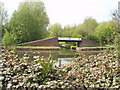
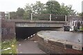
Life in B70 0DL offers a blend of practical amenities and historical charm. Nearby, residents can access retail options such as Asda, Lidl, and Heron Tipton, while the Black Country Spine Road connects to major commercial areas like Dudley Street Guns Village and Dartmouth Street. The Walsall Canal and River Tame provide scenic walking routes, linking the area to the Asda site and offering leisure opportunities. Rail stations like Dudley Port and Tipton provide swift access to regional hubs, complementing the dual carriageway’s connectivity. The 24-hour Asda superstore, situated on a former factory site, remains a focal point for shopping and employment. While the area lacks large parks, the canal and river paths contribute to a sense of green space. This mix of retail, transport, and light natural features supports a lifestyle that balances convenience with the area’s industrial heritage.
Amenities
Schools
The nearest school to B70 0DL is Newtown Primary School, a primary institution with an Ofsted rating of ‘good’. This rating indicates that the school meets national standards in teaching quality, student outcomes, and leadership. As the only listed school in the area, it serves as the primary educational option for local children, though no secondary schools are mentioned in the data. The presence of a primary school with a positive rating is a key consideration for families, offering a stable foundation for early education. However, prospective residents should investigate further for secondary schooling options, as the data does not specify their availability or quality. The school’s location within practical reach of the area reinforces its role in supporting local family life.
| Rank | School | Type | Entry gender | Ages |
|---|
Explore more schools in this area
Go to Schools tabDemographics
The population of B70 0DL has a median age of 47, with the majority aged between 30 and 64 years. This suggests a community skewed towards middle-aged adults, likely including families and professionals. Home ownership stands at 51%, with houses being the predominant accommodation type. The ethnic composition is predominantly White, reflecting the area’s historical ties to industrial workforces. While no specific deprivation data is provided, the age profile and ownership rates indicate a stable, settled population. The absence of younger demographics may influence local services and amenities, though the presence of Newtown Primary School suggests a focus on family needs. The compact population density of 1483 people/km² implies a mix of single-family homes and smaller dwellings, catering to both nuclear families and individuals.
Household Size
Accommodation Type
Tenure
Ethnic Group
Religion
Household Composition
Age
Household Deprivation
NS-SEC
Explore more demographic insights in this area
Go to Demographics tabPlanning
Planning Constraints
- Flood RiskPremium
- Ramsar Wetland SitesPremium
- Area of Outstanding Natural BeautyPremium
- Protected Nature ReservePremium
- Protected WoodlandPremium