Area Overview for B70 0BZ
Photos of B70 0BZ


Area Information
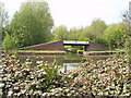
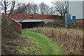
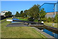
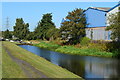
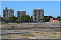
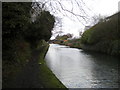
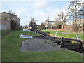
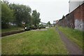
Living in B70 0BZ, a small residential cluster in Sandwell, England, means being part of a tightly knit community near Dudley, West Bromwich, and Wednesbury. The area’s population of 2,068 people is densely packed at 1,483 per square kilometre, reflecting its compact, residential character. Historically shaped by gravelly streams and industrial activity, the area now balances its past with modern amenities. A 24-hour Asda superstore, opened on a former factory site in 1998, anchors the local retail scene, while the Walsall Canal and River Tame offer quiet, accessible greenery. The Black Country Spine Road, a dual carriageway opened in 1995, ensures swift access to nearby towns and motorways. Daily life here is defined by proximity to shops, rail stations, and schools, with a focus on practicality over grandeur. The area’s mix of historic roots and contemporary infrastructure makes it a pragmatic choice for those prioritising convenience and connectivity over sprawling landscapes.
- Area Type
- Postcode
- Area Size
- Not available
- Population
- 2068
- Population Density
- 1483 people/km²
The property market in B70 0BZ is characterised by a 51% home ownership rate, with houses forming the primary accommodation type. This suggests a market skewed towards owner-occupied homes rather than rentals, though the exact number of rental properties is unspecified. Given the area’s small size and compact population, housing stock is likely limited, with fewer new developments. The dominance of houses over flats may appeal to buyers seeking space or garden access, but it also means the market is not geared toward high-density living. Proximity to transport links, including rail and the Black Country Spine Road, adds value for commuters. However, buyers should consider the area’s size and the potential for limited property choices, particularly for those seeking modern or specialist housing.
House Prices in B70 0BZ
No properties found in this postcode.
Energy Efficiency in B70 0BZ
Daily life in B70 0BZ is shaped by its proximity to retail, transport, and natural features. The area’s retail landscape includes Asda Great, Heron Tipton, and Lidl Tipton, offering a range of shopping options. The Walsall Canal and River Tame provide scenic routes for walking or cycling, with a footpath connecting the town centre to the Asda site. The 24-hour Asda superstore, located on a former factory site, is a major local hub, while a Wilko store operates in the old village centre. Rail and metro stations ensure easy access to nearby towns, and the Black Country Spine Road facilitates travel to larger cities. These amenities create a practical, community-focused lifestyle, though the area’s small size means it lacks large-scale leisure or cultural venues.
Amenities
Schools
The nearest school to B70 0BZ is Newtown Primary School, which serves the local community with a good Ofsted rating. This primary school is the only educational institution explicitly listed in the data, meaning families with older children may need to look further afield for secondary education. The presence of a rated primary school is a positive factor for parents prioritising early education, though the lack of secondary schools nearby could be a consideration for growing families. The school’s good rating indicates a standard of teaching and facilities that meets regulatory benchmarks, though no further details on curriculum or student outcomes are provided.
| Rank | School | Type | Entry gender | Ages |
|---|
Explore more schools in this area
Go to Schools tabDemographics
The community in B70 0BZ is predominantly composed of adults aged 30–64, with a median age of 47. This suggests a mature population, likely with established careers and families. Home ownership rates stand at 51%, indicating a mix of owner-occupied properties and rental units, though the exact proportion of renters is not specified. The area’s accommodation is primarily houses, not flats, reflecting a suburban or semi-rural layout. The predominant ethnic group is White, though no further breakdown of diversity is provided. The absence of specific data on deprivation or socioeconomic status means the area’s quality of life remains unquantified, but the presence of retail, transport, and schools suggests basic needs are met. The age profile and housing type suggest a stable, family-oriented environment with limited generational turnover.
Household Size
Accommodation Type
Tenure
Ethnic Group
Religion
Household Composition
Age
Household Deprivation
NS-SEC
Explore more demographic insights in this area
Go to Demographics tabPlanning
Planning Constraints
- Flood RiskPremium
- Ramsar Wetland SitesPremium
- Area of Outstanding Natural BeautyPremium
- Protected Nature ReservePremium
- Protected WoodlandPremium