Area Overview for B70 0BE
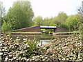
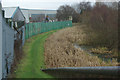
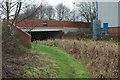
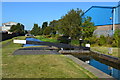
Photos of B70 0BE

Area Information
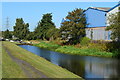
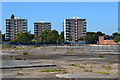
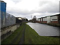
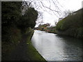
Living in B70 0BE means inhabiting a small, densely populated residential cluster in the West Midlands, with 2,068 residents packed into 1.4 km². The area’s name reflects its origins: a gravelly stream crossed by a bridge, likely the Oldbury arm of the River Tame. Historically tied to industry, it hosted factories and foundries until the late 1990s, but today, the landscape is shaped by retail and transport infrastructure. The 1998 Asda superstore on a former factory site remains a landmark, while the Black Country Spine Road, opened in 1995, connects residents to Bilston, Wednesbury, and the M5 motorway. Proximity to Dudley, West Bromwich, and Wednesbury offers access to larger towns without the congestion of city centres. Daily life balances practicality with a sense of rootedness, with the Walsall Canal and River Tame nearby, offering limited green space but a tangible link to the area’s industrial past. The population’s median age of 47 suggests a mature community, with many residents likely drawn by the area’s affordability and connectivity.
- Area Type
- Postcode
- Area Size
- Not available
- Population
- 2068
- Population Density
- 1483 people/km²
B70 0BE is characterised by a 51% home ownership rate, with houses forming the majority of accommodation types. This suggests a market skewed towards owner-occupied properties rather than rentals, though the small area size and limited data mean the rental sector’s role is unclear. The presence of houses, rather than flats or apartments, indicates a focus on family homes and long-term residency. Buyers in this area may find a stable market with fewer speculative investments, but the small population and proximity to industrial sites could limit property diversity. The 1998 Asda superstore on a former factory site highlights a shift from manufacturing to commercial use, potentially influencing property values nearby. However, with only 2,068 residents, the immediate surroundings may offer more options for buyers seeking larger or varied housing stock. The lack of data on property prices or recent developments means the market’s current state remains opaque, though the historical industrial legacy may present both challenges and opportunities for renovation or redevelopment.
House Prices in B70 0BE
No properties found in this postcode.
Energy Efficiency in B70 0BE
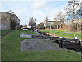
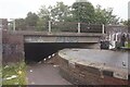
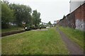
Residents of B70 0BE have access to a range of amenities within practical reach, including retail outlets like Asda Great, Lidl Tipton, and Heron Tipton, which cater to everyday shopping needs. The Black Country Spine Road links the area to nearby towns, while local metro spots such as Black Lake, Dudley Street Guns Village, and Dartmouth Street offer leisure and dining options. Rail stations at Dudley Port, Sandwell & Dudley, and Tipton provide easy access to regional hubs. The Walsall Canal and River Tame run through the eastern side, with a pedestrian footpath connecting the town centre to Asda, offering limited green space for walks. The 24-hour Asda superstore, opened in 1998 on a former factory site, remains a focal point for the community. While the area lacks large parks or cultural venues, its proximity to Dudley, West Bromwich, and Wednesbury means residents can access broader facilities. The mix of retail, transport, and minor natural features creates a practical, if modest, lifestyle with a focus on connectivity and convenience.
Amenities
Schools
The primary school nearest to B70 0BE is Newtown Primary School, which holds an Ofsted rating of ‘good’. This single primary school serves the area’s children, though no secondary schools are listed in the data. The absence of secondary education options within the postcode means families may need to look beyond B70 0BE for comprehensive schooling. The ‘good’ rating at Newtown Primary suggests a reliable foundation for early education, but the lack of diversity in school types—only a primary school—is notable. For families prioritising a range of educational institutions, this area may require additional planning, such as commuting to nearby towns like Dudley or West Bromwich. The school’s presence, however, indicates a basic infrastructure for local children, aligning with the area’s mature demographic and focus on stability over expansion.
| Rank | School | Type | Entry gender | Ages |
|---|
Explore more schools in this area
Go to Schools tabDemographics
The population of B70 0BE is 2,068, with a density of 1,483 people per km², reflecting a compact, closely knit community. The median age is 47, and 62% of residents fall within the 30–64 age range, indicating a predominantly adult population with a focus on middle-aged households. Home ownership stands at 51%, with houses being the primary accommodation type, suggesting a mix of family homes and long-term residents. The predominant ethnic group is White, though specific diversity metrics are not provided. The age profile implies a stable, low-turnover community, with fewer young families or retirees compared to other areas. This demographic structure may influence local services, with amenities tailored to adults rather than children or elderly residents. The lack of data on deprivation or income levels means the area’s quality of life remains unquantified, though the high home ownership rate and mature age group suggest a degree of economic stability.
Household Size
Accommodation Type
Tenure
Ethnic Group
Religion
Household Composition
Age
Household Deprivation
NS-SEC
Explore more demographic insights in this area
Go to Demographics tabPlanning
Planning Constraints
- Flood RiskPremium
- Ramsar Wetland SitesPremium
- Area of Outstanding Natural BeautyPremium
- Protected Nature ReservePremium
- Protected WoodlandPremium