Area Overview for B67 7RB
Photos of B67 7RB

Area Information
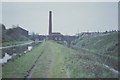
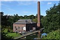
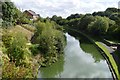
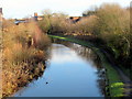
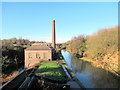
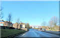
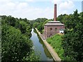
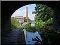
Living in B67 7RB means being part of a small, tightly knit residential cluster in England’s West Midlands. With a population of 1,719, this area is compact yet functional, offering a blend of historical roots and modern convenience. Situated in Sandwell, it lies within commuting distance of Birmingham, a city that anchors the region’s economic and cultural life. The area’s character is shaped by its industrial heritage, including connections to 18th-century engineering innovations like Boulton and Watt’s Soho Foundry. Daily life here balances proximity to urban amenities with a quieter, more residential vibe. The postcode’s limited size means residents share a close-knit community feel, with local landmarks such as the Grade II-listed Smethwick Public Hall and remnants of Telford’s 1829 canal engineering. While the area lacks large-scale commercial hubs, its strategic location near rail and metro lines ensures access to broader opportunities. For those seeking a blend of history, practicality, and connectivity, B67 7RB offers a distinct slice of West Midlands living.
- Area Type
- Postcode
- Area Size
- Not available
- Population
- 1719
- Population Density
- 10942 people/km²
The property market in B67 7RB is characterised by a 45% home ownership rate, with houses forming the predominant accommodation type. This suggests a market skewed towards owner-occupied properties rather than rental-focused housing. The presence of houses, as opposed to flats or apartments, indicates a preference for larger, more traditional living spaces, which may appeal to families or those seeking long-term stability. Given the area’s small size, the housing stock is likely limited in volume, meaning buyers should consider nearby areas for broader options. The 45% ownership rate also implies that nearly half the properties are rented, potentially offering opportunities for investors or those seeking rental income. However, the compact nature of B67 7RB means competition for properties may be higher, particularly for homes with specific features. Buyers should also note that the area’s historical and industrial legacy may influence property values, with heritage elements adding character but not necessarily increasing marketability.
House Prices in B67 7RB
No properties found in this postcode.
Energy Efficiency in B67 7RB
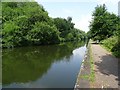
Residents of B67 7RB have access to a range of practical amenities within reach. Retail options include Farmfoods West, Asda Cape, and Iceland Smethwick, providing everyday shopping convenience. For public transport, five rail stations—Smethwick Rolfe Street, Smethwick Galton Bridge High Level, and Hawthorns—offer connections to Birmingham and beyond, while three metro stops (Kenrick Park, Handsworth Booth Street, Trinity Way) provide local mobility. The area’s historical ties to engineering and industry are reflected in landmarks like the Smethwick Engine, now housed in Birmingham’s Thinktank museum, and Galton Bridge, a remnant of Thomas Telford’s 1829 canal. Parks and open spaces are less explicitly detailed, but the proximity to Smethwick Locks and the remnants of the Birmingham Canal suggest opportunities for leisure. The mix of retail, transport, and heritage sites creates a lifestyle that balances practicality with a touch of historical interest, though larger-scale leisure facilities may require travel to nearby towns.
Amenities
Schools
| Rank | School | Type | Entry gender | Ages |
|---|
Explore more schools in this area
Go to Schools tabDemographics
The community in B67 7RB is predominantly composed of adults aged 30–64, with a median age of 47. This suggests a mature, stable population, likely with established careers and families. Home ownership stands at 45%, indicating a mix of owner-occupied and rental properties. The accommodation type is primarily houses, reflecting a residential area with more traditional housing stock. The predominant ethnic group is Asian, which influences the cultural fabric of the neighbourhood. This demographic profile implies a community focused on long-term stability, with residents likely prioritising family-oriented living. The absence of specific deprivation data means the area’s quality of life can be inferred from its low crime risk and practical amenities. For instance, the 69/100 safety score, which is below average, suggests a generally secure environment. These factors combined create a setting where residents can expect a balanced lifestyle with accessible services and a cohesive social structure.
Household Size
Accommodation Type
Tenure
Ethnic Group
Religion
Household Composition
Age
Household Deprivation
NS-SEC
Explore more demographic insights in this area
Go to Demographics tabPlanning
Planning Constraints
- Flood RiskPremium
- Ramsar Wetland SitesPremium
- Area of Outstanding Natural BeautyPremium
- Protected Nature ReservePremium
- Protected WoodlandPremium