Area Overview for B67 7JL
Photos of B67 7JL

Area Information
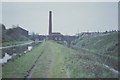
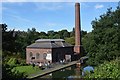
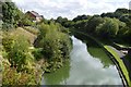
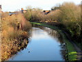
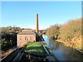
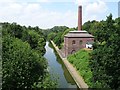
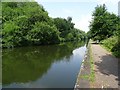
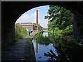
Living in B67 7JL means being part of a small, tightly knit residential cluster in England’s West Midlands. With a population of 2,150, this postcode area reflects the region’s industrial heritage, shaped by historical manufacturing sites like the Chance Brothers Glassworks in Smethwick. The community is predominantly middle-aged, with a median age of 47 and most residents falling between 30 and 64 years old. Over half of homes are owner-occupied, suggesting a stable, long-term presence in the area. The predominant ethnic group is Asian, adding to the cultural diversity. Daily life here is grounded in practicality, with easy access to rail and metro stations, and a range of retail outlets. While the area lacks natural beauty designations, its proximity to St. Paul’s Church—a Grade I listed building—offers a tangible link to the region’s industrial past. B67 7JL is not for those seeking a rural idyll, but it offers a compact, functional lifestyle with strong transport links and a sense of community rooted in local history.
- Area Type
- Postcode
- Area Size
- Not available
- Population
- 2150
- Population Density
- 2184 people/km²
The property market in B67 7JL is characterised by a 55% home ownership rate, with houses being the predominant accommodation type. This suggests a community where owner-occupation is common, and the housing stock is largely composed of family homes rather than flats or apartments. Given the small size of the postcode area, the property market is likely to be limited in scale, with buyers needing to consider nearby areas for more options. The focus on houses implies a demand for space, which may appeal to families or those seeking larger living environments. However, the lack of specific data on property prices or rental rates means the market’s affordability or competitiveness cannot be assessed. For buyers, this area offers a stable, residential-focused environment, but the limited size of the postcode may require a broader search for additional properties. The mix of owner-occupied and rented homes also indicates a balance between long-term residents and those in the rental market.
House Prices in B67 7JL
No properties found in this postcode.
Energy Efficiency in B67 7JL
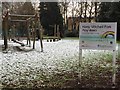
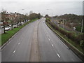
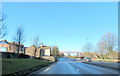
Daily life in B67 7JL is supported by a selection of retail and dining options, including Farmfoods West, Spar, and Tesco Birmingham, which provide essential shopping and food services. The proximity to rail and metro stations—such as Smethwick Galton Bridge and West Bromwich Central—enhances convenience for commuters and shoppers. While the area lacks extensive parks or leisure facilities, its transport links allow residents to access nearby green spaces or cultural venues in surrounding towns. The retail presence ensures that daily needs are met without long journeys, and the multiple transport options reduce reliance on private vehicles. The character of the area is practical, with a focus on accessibility and functionality. Residents benefit from a compact environment where essential amenities are within reach, though the absence of detailed information on leisure facilities means the full range of lifestyle options is not fully outlined. The combination of retail, transport, and nearby industrial heritage creates a functional, if unadorned, living experience.
Amenities
Schools
Residents of B67 7JL have access to a range of educational institutions, including primary schools, a special needs school, and a pupil referral unit. Leasowes Primary School and West Park College cater to younger children, while Holly Lodge High School College of Science, rated ‘good’ by Ofsted, provides primary education with a focus on science. Albert Bradford School is a special needs institution, and Ruskin House Pupil Referral Unit supports students with complex educational needs. This mix of school types ensures that families have options tailored to different requirements, from mainstream education to specialist support. The presence of both primary and secondary-level schools within proximity reduces the need for long commutes. However, the absence of secondary schools in the immediate area may necessitate travel for older students. The variety of institutions reflects the area’s commitment to inclusive education, though parents should consider the specific needs of their children when evaluating school options.
| Rank | School | Type | Entry gender | Ages |
|---|
Explore more schools in this area
Go to Schools tabDemographics
The residents of B67 7JL are predominantly adults aged 30–64, with a median age of 47. This suggests a community of established professionals and families, rather than a younger or elderly demographic. Home ownership rates are 55%, indicating a mix of owner-occupied and rented properties, though the majority of homes are owner-occupied. The accommodation type is primarily houses, which aligns with the area’s residential character. The predominant ethnic group is Asian, reflecting broader demographic trends in the West Midlands. While no specific deprivation data is provided, the age profile and home ownership figures suggest a population with relatively stable employment and housing conditions. The absence of detailed diversity metrics means the full extent of cultural variety is not quantified, but the presence of Asian communities is a clear feature. This demographic structure supports a community that values stability, with residents likely to have long-term ties to the area.
Household Size
Accommodation Type
Tenure
Ethnic Group
Religion
Household Composition
Age
Household Deprivation
NS-SEC
Explore more demographic insights in this area
Go to Demographics tabPlanning
Planning Constraints
- Flood RiskPremium
- Ramsar Wetland SitesPremium
- Area of Outstanding Natural BeautyPremium
- Protected Nature ReservePremium
- Protected WoodlandPremium