Area Overview for B67 5AB
Photos of B67 5AB


Area Information
Living in B67 5AB means being part of a small, tightly knit residential cluster in England, home to 1,730 people. The area’s compact size fosters a quiet, community-focused atmosphere, with no major urban sprawl. Residents here are predominantly adults aged 30–64, reflecting a mature demographic that values stability. While the area lacks large-scale amenities, its proximity to rail and metro networks ensures easy access to nearby towns and cities. Daily life is shaped by the local shops, schools, and transport links, with a focus on practicality over luxury. The low flood risk and absence of environmental constraints make it a straightforward place to live, though the moderate crime risk means standard security measures are advisable. For those seeking a balance between tranquillity and connectivity, B67 5AB offers a simple, no-frills lifestyle.
- Area Type
- Postcode
- Area Size
- Not available
- Population
- 1730
- Population Density
- 7867 people/km²
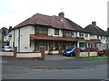
The property market in B67 5AB is characterised by a 37% home ownership rate, suggesting that the majority of residents rent rather than own their homes. This contrasts with areas where owner-occupation is more common, highlighting a rental-focused market. The primary accommodation type is houses, which are more prevalent than flats or apartments. Given the area’s small size and limited housing stock, properties here are likely to be in high demand, particularly among those seeking single-family homes. Buyers should consider the limited scope for expansion in the immediate vicinity, as the area’s compact nature means competition for available properties could be fierce. The market appears to cater to those prioritising stability over investment potential.
House Prices in B67 5AB
No properties found in this postcode.
Energy Efficiency in B67 5AB
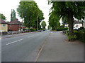
The lifestyle in B67 5AB is defined by its practical amenities, which include five retail outlets such as Aldi Warley and Iceland Bearwood. These shops provide everyday essentials, reducing the need for long trips to larger centres. The area’s rail and metro stations, including Smethwick Galton Bridge and Kenrick Park, offer convenient links to nearby towns, facilitating access to leisure, healthcare, and employment. While the area lacks large parks or entertainment venues, its proximity to transport hubs and basic retail options supports a straightforward, functional lifestyle. The presence of these amenities ensures that daily needs are met without the need for extensive travel, contributing to a low-maintenance, community-oriented way of life.
Amenities
Schools
The nearest school to B67 5AB is Bearwood Primary School, which serves the local community with a good Ofsted rating. This single primary school is a key asset for families, offering a reliable educational option for young children. The absence of secondary schools or additional educational institutions within the area means parents may need to consider commuting to nearby towns for higher education. However, the good rating at Bearwood Primary suggests a solid foundation for early learning. For families prioritising proximity to schools, this is a significant factor, though the lack of diversity in educational options could be a limitation for those requiring specialist provision.
| Rank | School | Type | Entry gender | Ages |
|---|
Explore more schools in this area
Go to Schools tabDemographics
The population of B67 5AB is 1,730, with a median age of 47, indicating a community skewed towards middle-aged adults. The most common age range is 30–64, suggesting a mix of established families and professionals. Home ownership stands at 37%, which is relatively low, pointing to a rental market that dominates the area. The primary accommodation type is houses, reflecting a preference for single-family homes over flats. The predominant ethnic group is White, with no data on other demographics. This composition implies a stable, long-term resident base, though the lower home ownership rate may indicate a transient element. The absence of specific deprivation data means quality of life is inferred from the area’s practical amenities and moderate risks.
Household Size
Accommodation Type
Tenure
Ethnic Group
Religion
Household Composition
Age
Household Deprivation
NS-SEC
Explore more demographic insights in this area
Go to Demographics tabPlanning
Planning Constraints
- Flood RiskPremium
- Ramsar Wetland SitesPremium
- Area of Outstanding Natural BeautyPremium
- Protected Nature ReservePremium
- Protected WoodlandPremium