Area Overview for B64 6ES
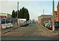
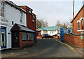
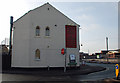
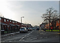
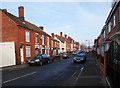
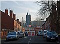
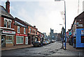
Photos of B64 6ES

Area Information
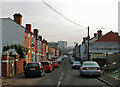
Living in B64 6ES means being part of a small, tightly knit residential cluster in Sandwell, West Midlands, just 8 miles west of Birmingham city centre. The area, encompassing Cradley Heath and Old Hill, has a population of 2329, reflecting its compact nature. Historically shaped by the chain-making industry, it retains echoes of its industrial past, including the Mary MacArthur Memorial Gardens and Haden Hill Park, which offer green spaces for residents. The community is anchored by its proximity to transport hubs like Old Hill Railway Station and Rowley Regis Metro, ensuring easy access to Birmingham and surrounding areas. With a median age of 47, the area is predominantly inhabited by adults aged 30–64, many of whom are likely drawn to its mix of local amenities, including independent schools and retail outlets. The presence of an enterprise zone in the eastern part suggests a focus on modern development, though the area still retains its working-class roots. For buyers, B64 6ES offers a blend of practicality and historical character, with a strong sense of local identity.
- Area Type
- Postcode
- Area Size
- Not available
- Population
- 2329
- Population Density
- 5815 people/km²
The property market in B64 6ES is characterised by a 47% home ownership rate, with houses being the primary accommodation type. This suggests a mix of owner-occupied homes and rental properties, though the relatively low home ownership rate indicates a significant portion of the housing stock is available for rent. The predominance of houses over flats or apartments implies a more traditional, family-oriented housing stock, which may appeal to buyers seeking larger properties. Given the area’s small size, the housing market is likely limited in scale, with limited scope for new developments. Buyers should consider the balance between rental availability and long-term investment potential. The presence of an enterprise zone nearby may influence future property values, though current data does not specify major employers or development projects.
House Prices in B64 6ES
No properties found in this postcode.
Energy Efficiency in B64 6ES
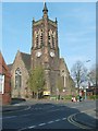
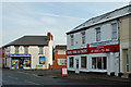
The lifestyle in B64 6ES is shaped by its accessible amenities, including retail outlets like Heron Old, Lidl Netherton, and Aldi Saltwells, which provide convenience for everyday shopping. The area’s proximity to rail and metro stations ensures easy access to Birmingham’s cultural and commercial hubs. Parks such as Haden Hill Park, featuring Haden Hall and the Mary MacArthur Memorial Gardens, offer recreational spaces for walking, picnics, and community events. The historical listed buildings, including Corngreaves Hall and the Church of the Holy Trinity, add a layer of heritage to the local character. While the area lacks large-scale leisure facilities, its compact size ensures that essential services are within practical reach, supporting a balanced lifestyle for residents.
Amenities
Schools
B64 6ES is served by a range of schools, including Corngreaves Primary School, Reddal Hill Primary School (Ofsted rating: good), Corngreaves Academy (Ofsted rating: good), and Impact Independent School (Ofsted rating: good). The mix of primary, academy, and independent schools offers families options tailored to different educational preferences. Reddal Hill and Corngreaves Academy, both rated good by Ofsted, provide strong state education, while Impact Independent School caters to those seeking private schooling. The presence of multiple schools within the area ensures accessibility for families, reducing the need for long commutes. The good Ofsted ratings suggest a generally high standard of education, which is a key consideration for homebuyers prioritising schools for their children.
| Rank | School | Type | Entry gender | Ages |
|---|
Explore more schools in this area
Go to Schools tabDemographics
The population of B64 6ES is 2329, with a median age of 47, indicating a mature community. The most common age group is adults aged 30–64, reflecting a stable, long-term resident base. Home ownership stands at 47%, meaning nearly half of properties are rented, suggesting a mix of owner-occupied and rental housing. The accommodation type is predominantly houses, which aligns with the area’s residential character. The predominant ethnic group is White, though specific diversity statistics are not provided. The age profile implies a community focused on established families and professionals, with services and amenities tailored to this demographic. The lower home ownership rate may indicate a higher proportion of renters, potentially influencing property market dynamics. The absence of specific deprivation data means the area’s quality of life can be inferred from its amenities and connectivity, which appear sufficient for daily needs.
Household Size
Accommodation Type
Tenure
Ethnic Group
Religion
Household Composition
Age
Household Deprivation
NS-SEC
Explore more demographic insights in this area
Go to Demographics tabPlanning
Planning Constraints
- Flood RiskPremium
- Ramsar Wetland SitesPremium
- Area of Outstanding Natural BeautyPremium
- Protected Nature ReservePremium
- Protected WoodlandPremium