Area Overview for B64 5LZ
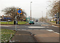
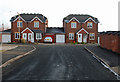
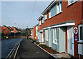
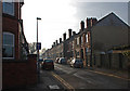
Photos of B64 5LZ
Area Information
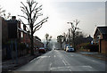
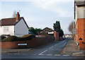
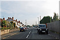
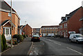
Living in B64 5LZ means being part of a small residential cluster in Sandwell, West Midlands, just 8 miles west of Birmingham city centre. This area, encompassing Cradley Heath and Old Hill, has a population of 2329, reflecting a tight-knit community with historical roots in heathland and 19th-century industry. The area’s character is shaped by its past as a hub for chain-making, though today it blends modest housing with pockets of green space like Haden Hill Park. Residents benefit from proximity to rail links and a range of local amenities. The postcode’s compact size means daily life revolves around nearby shops, schools, and transport hubs. With a median age of 47, the community is predominantly middle-aged adults, many of whom own their homes. The area’s appeal lies in its balance of practicality and heritage, offering a quieter alternative to urban centres without sacrificing connectivity. For buyers, B64 5LZ provides a snapshot of post-industrial England, where history and modernity coexist in a tightly woven neighbourhood.
- Area Type
- Postcode
- Area Size
- Not available
- Population
- 2329
- Population Density
- 5815 people/km²
B64 5LZ is primarily a home-ownership area, with 47% of residents owning their properties. The accommodation type is predominantly houses, which is notable for a small postcode area, suggesting a mix of semi-detached and terraced homes. This contrasts with larger urban centres where flats dominate. The housing stock reflects a suburban character, with properties likely spread across the small residential cluster. For buyers, the low population density and house-centric market mean competition is limited, though the area’s compact size means proximity to amenities is both a benefit and a constraint. The lack of specific data on property prices or recent transactions means market trends are unclear, but the predominance of owner-occupied homes suggests a stable, long-term resident base. Investors should consider the balance between housing supply and demand, particularly given the area’s historical industrial legacy and modern retail connectivity.
House Prices in B64 5LZ
No properties found in this postcode.
Energy Efficiency in B64 5LZ
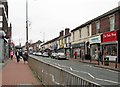
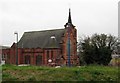
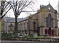
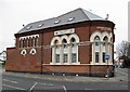
Residents of B64 5LZ enjoy a range of nearby amenities, including five retail outlets such as Tesco Cradley and Asda Netherton, ensuring everyday shopping needs are met. The area’s rail and metro stations provide easy access to broader networks, while the proximity to Haden Hill Park offers green space for recreation. The historical presence of industrial sites has given way to modern enterprise zones, though specific leisure facilities are not detailed in the data. The mix of retail, transport, and open space supports a practical lifestyle, with convenience prioritised over luxury. Local parks and listed buildings like Corngreaves Hall add character, though the area’s focus remains on functional living. For families, the combination of schools and shops creates a self-contained environment, though cultural or entertainment options may require travel to nearby towns. The area’s small size means amenities are closely clustered, reducing the need for long commutes.
Amenities
Schools
Residents of B64 5LZ have access to a range of educational institutions, including Corngreaves Primary School and Reddal Hill Primary School, both rated ‘good’ by Ofsted. Corngreaves Academy, an academy school, also holds a ‘good’ rating, while Impact Independent School, a private institution, similarly performs well. This mix of state and independent schools offers families flexibility, though the absence of secondary school data means long-term educational planning may require looking beyond the immediate area. The presence of multiple schools with strong ratings suggests a focus on quality education, which could be a draw for families. However, the lack of specific data on school catchment areas or pupil numbers means potential buyers should verify proximity and availability. The variety of school types reflects the area’s diversity in educational provision, though the limited number of institutions may necessitate commuting for certain needs.
| Rank | School | Type | Entry gender | Ages |
|---|
Explore more schools in this area
Go to Schools tabDemographics
The population of B64 5LZ is 2329, with a median age of 47, indicating a mature demographic skewed towards adults aged 30–64. Home ownership stands at 47%, suggesting a mix of owner-occupied and rental properties. The predominant accommodation type is houses, which is unusual for urban areas but reflects the area’s suburban layout. The predominant ethnic group is White, though no specific data on diversity or deprivation is provided. This age profile suggests a community focused on stability, with many residents likely established in their careers or retired. The lack of younger families may influence local amenities, though schools in the area cater to primary and secondary education. The 47% home ownership rate implies a moderate rental market, with potential for investment in property. The absence of detailed diversity metrics means broader social dynamics remain unexplored in the data.
Household Size
Accommodation Type
Tenure
Ethnic Group
Religion
Household Composition
Age
Household Deprivation
NS-SEC
Explore more demographic insights in this area
Go to Demographics tabPlanning
Planning Constraints
- Flood RiskPremium
- Ramsar Wetland SitesPremium
- Area of Outstanding Natural BeautyPremium
- Protected Nature ReservePremium
- Protected WoodlandPremium