Area Overview for B64 5AH
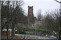
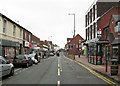
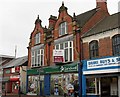
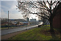
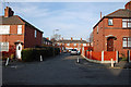
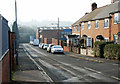
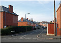
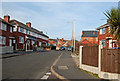
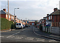
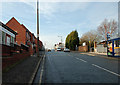
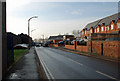
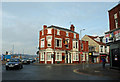
Photos of B64 5AH
Area Information
Living in B64 5AH means being part of a small, defined postcode area in Sandwell, West Midlands, nestled in the Black Country, around 8 miles west of Birmingham. This area, known as Cradley Heath and Old Hill Ward, has a population of 2094, reflecting its compact residential cluster. Historically a heathland settled by squatters in the 17th century, it evolved into a hub for chain-making industries in the 19th and early 20th centuries. Today, its character blends industrial heritage with modern living. The area is served by multiple railway stations, including Cradley Heath and Old Hill, linking residents to nearby cities. Nearby amenities like Lidl Cradley, Tesco Cradley, and Haden Hill Park provide daily conveniences. While the community is small, it is connected to broader networks, offering access to retail, transport, and green spaces. The area’s proximity to Birmingham and its historical roots make it a place where tradition meets practicality, appealing to those seeking a balance between local charm and regional connectivity.
- Area Type
- Postcode
- Area Size
- Not available
- Population
- 2094
- Population Density
- 2573 people/km²
The property market in B64 5AH is characterised by a 46% home ownership rate, indicating that nearly half of properties are rented. This suggests a rental market with opportunities for both landlords and tenants, though the small size of the area means competition for available homes. The predominant accommodation type is houses, which are typically larger and suited to families or individuals seeking more space. Given the area’s proximity to Birmingham and its transport links, properties here may appeal to commuters or those desiring a quieter base outside the city. However, the limited data on property types or prices means buyers should consider nearby areas for a broader range of options. The mix of owner-occupied and rental properties also implies a balance between long-term residents and those seeking temporary housing.
House Prices in B64 5AH
No properties found in this postcode.
Energy Efficiency in B64 5AH
Daily life in B64 5AH is shaped by its proximity to retail, green spaces, and historical sites. Nearby amenities include supermarkets such as Lidl Cradley, Iceland Cradley, and Tesco Cradley, offering convenience for shopping. Haden Hill Park, with its historic Haden Hall and Tudor structures, provides recreational space and a connection to the area’s heritage. The enterprise zone in the eastern part of the ward hints at economic activity, though specific employers are not listed. For leisure, the Mary MacArthur Memorial Gardens and listed buildings like Corngreaves Hall add cultural value. The mix of retail, parks, and historical sites creates a lifestyle that balances practicality with local character, appealing to those who appreciate both modern amenities and heritage.
Amenities
Schools
The nearest school to B64 5AH is Cradley Heath Nursery School, a nursery providing early education for young children. No other schools are listed in the data, so families with older children may need to look beyond the immediate area for primary or secondary education. The presence of a nursery suggests that the community supports early childhood development, though it does not indicate the quality or Ofsted rating of the school. For families requiring a broader range of educational options, nearby towns like Birmingham or Dudley may offer more comprehensive schooling. The limited local school infrastructure could be a consideration for parents prioritising proximity to schools, though the area’s transport links may mitigate this by enabling access to larger educational hubs.
| Rank | School | Type | Entry gender | Ages |
|---|
Explore more schools in this area
Go to Schools tabDemographics
The population of B64 5AH has a median age of 47, with the most common age range being adults aged 30–64. This suggests a mature, settled community with a focus on family life and long-term residency. Home ownership stands at 46%, indicating a mix of owner-occupied and rental properties. The predominant accommodation type is houses, reflecting a suburban or semi-rural layout. The predominant ethnic group is White, though specific data on diversity or deprivation is not provided. The age profile implies a community with established careers and families, likely prioritising stability over transient living. With no data on income distribution or deprivation, it is reasonable to infer that the area may cater to middle-income households seeking a quieter, connected lifestyle. The absence of younger demographics may also suggest limited demand for student housing or family-focused amenities.
Household Size
Accommodation Type
Tenure
Ethnic Group
Religion
Household Composition
Age
Household Deprivation
NS-SEC
Explore more demographic insights in this area
Go to Demographics tabPlanning
Planning Constraints
- Flood RiskPremium
- Ramsar Wetland SitesPremium
- Area of Outstanding Natural BeautyPremium
- Protected Nature ReservePremium
- Protected WoodlandPremium