Area Overview for B63 4SU
Photos of B63 4SU


Area Information
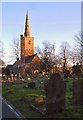
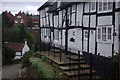
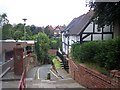
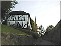
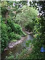
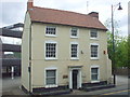
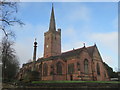
Living in B63 4SU means being part of a small, tightly knit residential cluster in the West Midlands, nestled within the Metropolitan Borough of Dudley. The area, part of Belle Vale Ward, has roots stretching back to the 18th century, with evidence of historic buildings and industrial heritage shaping its character. With a population of 1,865, it is a quiet, low-density postcode where houses dominate the housing stock. The proximity to Halesowen and its historical landmarks, such as the Regency-era gentleman’s residence and the 19th-century Bloomfield Works, adds a layer of architectural interest. Daily life here balances suburban tranquillity with access to nearby towns, while the area’s industrial past—marked by timber yards and sawmills—hints at a working-class legacy. Residents benefit from a mix of practical amenities and historical context, making it a place where tradition meets modern convenience. The postcode’s compact size means it is ideal for those seeking a manageable, community-focused environment without the pressures of larger urban centres.
- Area Type
- Postcode
- Area Size
- Not available
- Population
- 1865
- Population Density
- 5812 people/km²
The property market in B63 4SU is defined by a 65% home ownership rate, with houses forming the majority of the housing stock. This suggests a predominantly owner-occupied area, where properties are likely to be family homes rather than rental units. The compact nature of the postcode—described as a small residential cluster—means the housing stock is limited, and buyers may need to consider nearby areas for more options. The prevalence of houses, rather than flats or apartments, indicates a preference for traditional, standalone homes, which can appeal to those seeking space and privacy. However, the small size of the area may limit availability, particularly for specific property types. For buyers, this means a focus on existing homes rather than new developments, with potential for long-term value retention in a stable, low-density market.
House Prices in B63 4SU
No properties found in this postcode.
Energy Efficiency in B63 4SU
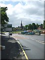
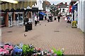
Residents of B63 4SU have access to a range of practical amenities within reach. Local retail options include Co-op Halesowen, Lidl Halesowen, and Tesco Hasbury, providing everyday shopping convenience. The proximity to railway stations and metro stops—such as Old Hill and Kenrick Park—ensures easy access to larger towns and cities, while also supporting local travel. Though the area is small, its connections to Halesowen and surrounding districts mean residents can enjoy a broader array of leisure and cultural opportunities. The presence of historic sites, such as the Regency gentleman’s residence, adds a unique character to daily life, blending heritage with modern living. This balance of practicality and local history makes B63 4SU a place where convenience meets quiet charm.
Amenities
Schools
| Rank | School | Type | Entry gender | Ages |
|---|
Explore more schools in this area
Go to Schools tabDemographics
The population of B63 4SU is 1,865, with a median age of 47, indicating a community skewed towards middle-aged and older residents. The most common age range is 30–64 years, suggesting a stable demographic with a strong presence of working-age adults. Home ownership sits at 65%, reflecting a majority of owner-occupied properties, which is typical of suburban areas. The predominant accommodation type is houses, aligning with the residential cluster’s character. The predominant ethnic group is White, which is consistent with broader trends in the West Midlands. This demographic profile implies a mature, settled community with established routines and limited turnover. The absence of specific data on deprivation or diversity means the area’s social dynamics are not fully detailed, but the age and ownership statistics suggest a focus on long-term residency and family-oriented living.
Household Size
Accommodation Type
Tenure
Ethnic Group
Religion
Household Composition
Age
Household Deprivation
NS-SEC
Explore more demographic insights in this area
Go to Demographics tabPlanning
Planning Constraints
- Flood RiskPremium
- Ramsar Wetland SitesPremium
- Area of Outstanding Natural BeautyPremium
- Protected Nature ReservePremium
- Protected WoodlandPremium