Area Overview for B63 3XS
Photos of B63 3XS
Area Information
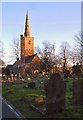
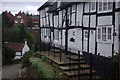
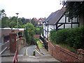
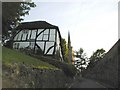
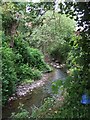
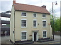
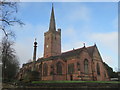
Living in B63 3XS means residing within a specific postcode cluster covering a small residential area in Halesowen. The Civil parish of Belle Vale Ward sits within the Metropolitan Borough of Dudley, where the local landscape reflects a history of settlement dating back to the 18th century. Archaeological recordings reveal historic fabric, including a Regency period gentleman's residence that retains much of its original character despite later alterations. You will find the vicinity marked by the industrial heritage of James Grove & Sons, Bloomfield Works on Stourbridge Road. This site includes a sawmill building documented as existing since 1888, standing as a witness to the local economy's past reliance on manufacturing and timber. The postal code B63 3UN identifies the broader area with coordinates near 52.46274, -2.076168, though your immediate surroundings focus on the specific residential cluster defined by B63 3XS. Daily life here is shaped by this dense residential fabric set against a backdrop of historical significance. The mix of agricultural smallholdings from the late 18th century and 19th century industrial structures gives the neighbourhood a distinct character. While modern developments exist, the area maintains a direct link to its regional reorganisation within the West Midlands since 1974. When you walk around B63 3XS, you encounter a community rooted in these layers of history rather than a generic suburban sprawl. The concentration of people living in this small footprint means you are part of a tightly knit section of the wider ward.
- Area Type
- Postcode
- Area Size
- Not available
- Population
- 1580
- Population Density
- 1194 people/km²
Buying a home in B63 3XS offers entry into a predominantly owner-occupied sector where 65% of residents hold title to their property. This statistic reveals a market characterised by stability rather than a transient rental turnover. The accommodation type is exclusively houses, so you will not find apartments or purpose-built flats within this specific postcode boundary. If you are looking to purchase, you are buying into a stock of traditional residential buildings that have formed the nucleus of the Belle Vale Ward. The high homeownership rate suggests that the local market has installed a culture of long-term residency. People invest in their houses because they intend to stay through market cycles and life changes. For a buyer, this means you are likely encountering sellers who have maintained their homes for many years, potentially with well-known histories of care. The presence of historic structures like the 18th and 19th century buildings on Stourbridge Road indicates that some properties may have significant architectural features. However, the market is a small cluster, meaning inventory might be limited compared to larger suburbs. You must be prepared to act quickly when a suitable house in B63 3XS becomes available. The focus here is on ownership equity and residential security rather than the flexibility of a rental arrangement.
House Prices in B63 3XS
No properties found in this postcode.
Energy Efficiency in B63 3XS
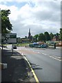
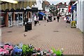
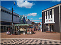
Daily life in B63 3XS benefits from a network of amenities within practical reach that cater to shopping, travel, and leisure needs. For your routine shopping, you have access to five notable retail locations, including Tesco Stourbridge, Aldi Halesowen, and Heron Halesowen. These supermarkets are the primary destinations for groceries and household essentials, removing the need for long drives for basic necessities. Your transport options are equally diverse, with five railway stations nearby to facilitate regular train travel. Old Hill Railway Station, Cradley Heath Railway Station, and Rowley Regis Railway Station provide rail links that connect you to wider networks. If you prefer the metro system, there are five metro waypoints available, including Kenrick Park, Trinity Way, and West Bromwich Central. This combination of rail and metro access means you can travel into Birmingham or beyond without relying solely on a car. The integration of retail and transport hubs creates a convenient environment where you can run errands and commute efficiently. When you plan your weekend, the proximity to these vocational and commercial sites adds significant value to your living situation in B63 3XS. You enjoy the convenience of major chain stores and transport links without leaving the immediate region.
Amenities
Schools
Families living in B63 3XS have access to a specific list of educational institutions catering to different stages of childhood development. Newfield Park Primary School serves the local area as a primary institution for younger children. Nearby, Halesowen CofE Primary School also offers primary education and holds a Good Ofsted rating, ensuring a standard of quality you can verify. The Earls High School appears twice in the local register, first listed as a primary institution and again as an academy with a Good Ofsted rating. This dual listing indicates a comprehensive provision for students within the immediate vicinity of the postcode. Further up the educational ladder, Halesowen College serves as a sixth-form institution, providing further education opportunities for older teenagers. The mix of primary schools and a sixth-form college creates a continuum of support for local families without the need for extensive commuting. You can find a primary education option with a Good Ofsted rating right near your doorstep at Halesowen CofE Primary School. The presence of The Earls High School as an academy adds a layer of modern governance to the local academic landscape. When you consider schools near B63 3XS, you have choices ranging from specific faith-based primaries to academies and sixth-form colleges, all situated to support the needs of children in this ward.
| Rank | School | Type | Entry gender | Ages |
|---|---|---|---|---|
| 1 | Newfield Park Primary School | primary | N/A | N/A |
| 2 | Halesowen CofE Primary School | primary | N/A | N/A |
| 3 | The Earls High School | primary | N/A | N/A |
| 4 | Halesowen College | sixth-form | N/A | N/A |
| 5 | The Earls High School | academy | N/A | N/A |
Explore more schools in this area
Go to Schools tabDemographics
The community in B63 3XS is defined by a total population of 1,580 residents living at a density of 1,194 people per square kilometre. This density indicates a compact living environment where homes are in close proximity to one another. The demographic profile shows a median age of 47 years, with the most common age range being adults between 30 and 64 years. This group forms the backbone of the local population, suggesting an area where you will largely meet middle-aged families and established households. Home ownership stands at 65%, meaning more than two-thirds of residents own their homes outright or with a mortgage. This figure is considerably higher than average for many metropolitan areas, pointing to a settled community where people have stayed for the long term. The predominant ethnic group in this postcode is White, reflecting the traditional demographic composition of the West Midlands region. Accommodation in B63 3XS consists primarily of houses, offering detached, semi-detached, or terraced properties rather than flats or apartments. You do not need to work from a block of flats if you value ground-floor access and private gardens. The majority of families living in B63 3XS seek the stability that comes with owning a house in a high-density but predominantly property-owner neighbourhood.
Household Size
Accommodation Type
Tenure
Ethnic Group
Religion
Household Composition
Age
Household Deprivation
NS-SEC
Explore more demographic insights in this area
Go to Demographics tabPlanning
Planning Constraints
- Flood RiskPremium
- Ramsar Wetland SitesPremium
- Area of Outstanding Natural BeautyPremium
- Protected Nature ReservePremium
- Protected WoodlandPremium
- Crime RiskPremium