Area Overview for B63 3SN
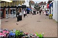
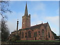
Photos of B63 3SN


Area Information
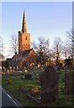
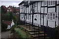
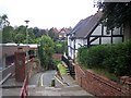
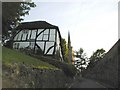
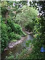
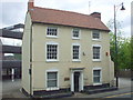
Living in B63 3SN means being part of a small, tightly knit residential cluster in Halesowen, West Midlands. With a population of 1,849, the area is compact but rich in historical character. The ward falls within the Metropolitan Borough of Dudley, a region shaped by 18th-century settlements and 19th-century industrial activity. Historic buildings, including a Regency-era gentleman’s residence and remnants of the Bloomfield Works sawmill, hint at the area’s layered past. Daily life here balances modern convenience with heritage, with nearby rail and metro stations offering easy access to surrounding towns. The community is mature, with a median age of 47, and a focus on practical living. While the area lacks large-scale amenities, its proximity to retail hubs and transport links makes it a viable choice for those prioritising connectivity over sprawling urban spaces.
- Area Type
- Postcode
- Area Size
- Not available
- Population
- 1849
- Population Density
- 6637 people/km²
The property market in B63 3SN is characterised by a high proportion of rental properties, with only 19% of homes owner-occupied. Flats dominate the housing stock, aligning with the area’s compact, residential nature. This suggests a focus on affordability and practicality over spacious family homes. Buyers seeking owner-occupied properties may find limited options, with the market skewed towards tenants. The small size of the postcode area means the surrounding regions are likely to offer more varied housing, though proximity to transport links may make commuting to nearby towns a key consideration for potential buyers.
House Prices in B63 3SN
No properties found in this postcode.
Energy Efficiency in B63 3SN
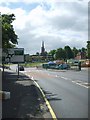
The lifestyle in B63 3SN is shaped by its proximity to retail and transport hubs. Nearby shops include Heron Halesowen, Iceland Halesowen, and Aldi Halesowen, offering everyday convenience. Rail and metro stations provide access to wider networks, facilitating both local and regional travel. While the area’s historic buildings and industrial heritage add character, the lack of detailed information on parks or leisure facilities means the community’s recreational options are not fully outlined. Nonetheless, the practical reach of amenities suggests a functional, service-oriented lifestyle for residents.
Amenities
Schools
The nearest school to B63 3SN is Our Lady and St Kenelm RC School, a primary institution with a Good Ofsted rating. This school serves the local community, providing education for younger children. However, no secondary schools are listed in the data, which may require families to consider nearby towns for further education. The presence of a well-rated primary school is a positive for families, though the lack of secondary options could be a practical challenge for those planning long-term residency.
| Rank | School | Type | Entry gender | Ages |
|---|
Explore more schools in this area
Go to Schools tabDemographics
The population of B63 3SN is 1,849, with a median age of 47 and the majority of residents aged 30–64. Only 19% of households are owner-occupied, suggesting a rental market dominance. Flats are the primary accommodation type, reflecting a preference for high-density living. The predominant ethnic group is White, with no specific data on other demographics. This age profile indicates a community of established professionals and families, though the low home ownership rate may suggest a transient or younger workforce. The absence of detailed diversity statistics means the area’s cultural composition remains largely unexplored in the data.
Household Size
Accommodation Type
Tenure
Ethnic Group
Religion
Household Composition
Age
Household Deprivation
NS-SEC
Explore more demographic insights in this area
Go to Demographics tabPlanning
Planning Constraints
- Flood RiskPremium
- Ramsar Wetland SitesPremium
- Area of Outstanding Natural BeautyPremium
- Protected Nature ReservePremium
- Protected WoodlandPremium