Area Overview for B63 3LF
Photos of B63 3LF

Area Information
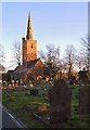
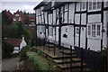
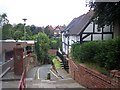
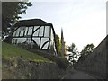
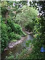
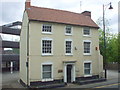
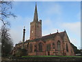
B63 3LF is a compact residential postcode in Dudley, part of the historic Halesowen area in the West Midlands. With a population of 1,580 and a density of 1,194 people per square kilometre, it reflects a tightly knit community. The area’s roots stretch back to the 18th century, with evidence of industrial and agricultural activity shaping its development. Today, it balances historic charm with modern convenience, situated near Stourbridge and within reach of urban amenities. Residents benefit from proximity to rail networks and a mix of retail options, while the surrounding landscape hints at the region’s industrial heritage. The postcode’s small size means a strong sense of local identity, with community ties reinforced by shared access to schools, parks, and transport links. For buyers, B63 3LF offers a blend of stability and practicality, ideal for those seeking a family-oriented environment with established infrastructure.
- Area Type
- Postcode
- Area Size
- Not available
- Population
- 1580
- Population Density
- 1194 people/km²
B63 3LF is predominantly an owner-occupied area, with 65% of residents living in homes they own. The accommodation type is largely houses, which is typical for smaller, residential postcode areas. This suggests a market focused on family homes rather than high-density housing or rental properties. The concentration of houses may indicate a preference for private, semi-detached or detached properties, which are common in suburban or semi-rural settings. For buyers, this means a limited but stable selection of properties, often with established gardens and private outdoor space. The small size of the postcode means the immediate surroundings are key—proximity to transport links and amenities will be critical factors for those considering purchase.
House Prices in B63 3LF
No properties found in this postcode.
Energy Efficiency in B63 3LF
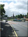
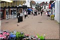
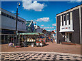
Residents of B63 3LF have access to essential amenities within practical reach. Retail options include Tesco Stourbridge, Heron Halesowen, and Aldi Halesowen, providing everyday shopping convenience. The rail network offers frequent services to nearby stations, while metro links connect to key urban hubs. Although specific parks or leisure facilities are not named in the data, the proximity to Halesowen—a town with historical and cultural sites—suggests opportunities for recreation. The area’s mix of retail, transport, and historical context creates a lifestyle that balances practicality with regional character, supporting both daily needs and community engagement.
Amenities
Schools
Residents of B63 3LF have access to a range of educational institutions, including Newfield Park Primary School, which serves the local primary age group. Halesowen CofE Primary School, rated ‘good’ by Ofsted, offers another primary option. The Earls High School, an academy also rated ‘good’, provides secondary education, while Halesowen College caters to sixth-form students. The mix of school types ensures families can choose between state and academy provision, with at least two institutions receiving positive evaluations. This diversity supports educational continuity from early years through to further education, making the area appealing to families prioritising school quality.
| Rank | School | Type | Entry gender | Ages |
|---|---|---|---|---|
| 1 | Newfield Park Primary School | primary | N/A | N/A |
| 2 | Halesowen CofE Primary School | primary | N/A | N/A |
| 3 | The Earls High School | primary | N/A | N/A |
| 4 | Halesowen College | sixth-form | N/A | N/A |
| 5 | The Earls High School | academy | N/A | N/A |
Explore more schools in this area
Go to Schools tabDemographics
The population of B63 3LF has a median age of 47, with the majority of residents aged between 30 and 64. This suggests a mature, settled community, likely with a focus on family homes and long-term residency. Home ownership is strong, with 65% of households owning their properties, indicating a stable housing market. The predominant accommodation type is houses, which aligns with the area’s residential character. The predominant ethnic group is White, reflecting the broader demographic trends in Dudley. While specific data on deprivation is absent, the high home ownership rate and median age suggest a relatively secure economic profile. However, the absence of detailed diversity metrics means the full picture of social composition remains partially obscured.
Household Size
Accommodation Type
Tenure
Ethnic Group
Religion
Household Composition
Age
Household Deprivation
NS-SEC
Explore more demographic insights in this area
Go to Demographics tabPlanning
Planning Constraints
- Flood RiskPremium
- Ramsar Wetland SitesPremium
- Area of Outstanding Natural BeautyPremium
- Protected Nature ReservePremium
- Protected WoodlandPremium
- Crime RiskPremium