Area Overview for B63 3AH
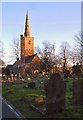
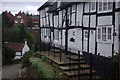
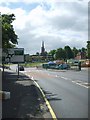
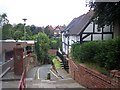
Photos of B63 3AH
Area Information
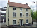
B63 3AH is a small residential postcode area in England, part of the Halesowen region within Dudley Metropolitan Borough. With a population of 1,443, it reflects a compact, suburban setting integrated into the broader West Midlands urban landscape. Historically, Halesowen was an exclave of Shropshire, later transferred to Worcestershire in 1844, and now forms part of the Black Country’s connected suburbs. The area is characterised by a mix of older housing stock and modern developments, with a focus on family-oriented living. Daily life here is shaped by proximity to local amenities, schools, and transport links, while the surrounding area offers access to green spaces like The Leasowes. The community is defined by its stability, with a majority of residents owning their homes and a median age of 47 suggesting a mature demographic. Living in B63 3AH means balancing suburban convenience with the historical and cultural layers of a region once central to medieval estates and industrial expansion.
- Area Type
- Postcode
- Area Size
- Not available
- Population
- 1443
- Population Density
- 3114 people/km²
The property market in B63 3AH is dominated by owner-occupied homes, with 76% of properties owned by residents rather than rented. This suggests a stable, long-term community with little turnover, which can be advantageous for buyers seeking a settled environment. The accommodation type is primarily houses, indicating a focus on family homes with more space than apartments or flats. This contrasts with areas where rental demand drives a higher proportion of leasehold properties. For buyers, this means a market where properties are likely to be in good condition, with potential for long-term value retention. The small size of the area means that the immediate surroundings may offer similar housing stock, making it important for buyers to consider broader regional trends when assessing property availability and pricing.
House Prices in B63 3AH
No properties found in this postcode.
Energy Efficiency in B63 3AH
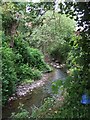
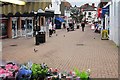
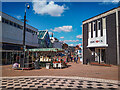
Residents of B63 3AH benefit from a range of nearby amenities, including retail outlets such as Iceland Halesowen, Heron Halesowen, and Lidl Halesowen, which cater to everyday shopping needs. The area’s proximity to rail and metro stations ensures easy access to public transport, facilitating travel to nearby towns and cities. For leisure, The Leasowes, a 57-hectare public park with 18th-century landscape features, offers green space for walking, picnics, and outdoor activities. The combination of practical retail options, efficient transport links, and accessible natural spaces contributes to a balanced lifestyle, blending suburban convenience with recreational opportunities. This mix supports both daily living and quality of life, making the area appealing to families and individuals seeking a well-rounded environment.
Amenities
Schools
Residents of B63 3AH have access to several primary schools, including Tenterfields Primary School, Manor Way Primary School, and The Mount School, which specialises in supporting students with additional needs. Two of these, Manor Way Primary Academy and Tenterfields Primary Academy, hold a ‘good’ Ofsted rating, indicating strong educational standards. The presence of both mainstream and special schools provides families with options tailored to their children’s requirements, from general education to specialist support. This diversity in school types reflects the area’s focus on inclusivity and accessibility, ensuring that parents can find appropriate provision for their children’s learning needs. The proximity of these schools to residential areas underscores the community’s commitment to education, with a mix of established and academically performing institutions.
| Rank | School | Type | Entry gender | Ages |
|---|
Explore more schools in this area
Go to Schools tabDemographics
The population of B63 3AH has a median age of 47, with the most common age range being adults aged 30–64. This indicates a community skewed toward middle-aged and older residents, likely reflecting long-term settlement patterns. Home ownership is high at 76%, suggesting a stable, owner-occupied demographic rather than a transient rental market. The predominant accommodation type is houses, which aligns with the area’s suburban character and may appeal to families seeking space. The predominant ethnic group is White, though specific data on diversity is not provided. The age profile and home ownership figures imply a community with established roots, where residents are likely to have long-term ties to the area. This demographic structure may influence local services and amenities, with a focus on family-oriented infrastructure rather than transient needs.
Household Size
Accommodation Type
Tenure
Ethnic Group
Religion
Household Composition
Age
Household Deprivation
NS-SEC
Explore more demographic insights in this area
Go to Demographics tabPlanning
Planning Constraints
- Flood RiskPremium
- Ramsar Wetland SitesPremium
- Area of Outstanding Natural BeautyPremium
- Protected Nature ReservePremium
- Protected WoodlandPremium