Area Overview for B62 0NS
Photos of B62 0NS
Area Information
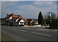
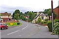
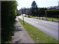
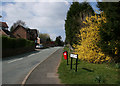
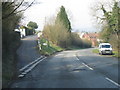
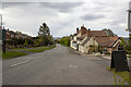
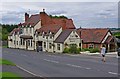
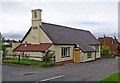
Living in B62 0NS means inhabiting a small, tightly knit village in Worcestershire’s Bromsgrove District. With a population of 1,153 and a density of 762 people per square kilometre, this area blends rural tranquillity with proximity to urban amenities. Situated on the east side of the Clent Hills, just 4 miles south of Halesowen, it offers a mix of natural beauty and historical significance. The village is anchored by St Kenelm’s Church, a 12th-century Grade I listed building, and features walking trails across the Clent and Walton Hills. Daily life here is characterised by a slow pace, with local shops, a pub-restaurant, and a post office along Bromsgrove Road. The area’s charm lies in its low population density and historical roots, such as its 1841 constitution as a chapelry. Residents benefit from nearby rail links to Hagley, Old Hill, and Longbridge, while the village’s rural setting appeals to those seeking a peaceful lifestyle without complete isolation.
- Area Type
- Postcode
- Area Size
- Not available
- Population
- 1153
- Population Density
- 762 people/km²
The property market in B62 0NS is dominated by owner-occupied homes, with 81% of properties owned by their residents. The accommodation type is primarily houses, which is typical for rural and semi-rural areas. This suggests a market skewed towards family homes and long-term residents rather than a rental-focused demographic. The high home ownership rate indicates a stable community with limited turnover, which can be appealing to buyers seeking a settled environment. However, the small population size—1,153 people—means the housing stock is limited, and properties may be in short supply. For buyers, this could mean higher competition for available homes, though the predominance of houses may offer more space and privacy than urban alternatives. The area’s proximity to rail links and natural amenities adds to its appeal for those prioritising quality of life over investment potential.
House Prices in B62 0NS
No properties found in this postcode.
Energy Efficiency in B62 0NS
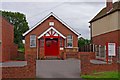
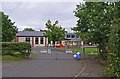
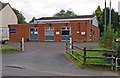
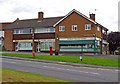
The lifestyle in B62 0NS is shaped by its rural character and proximity to natural spaces. Local amenities include a post office, butcher, pub-restaurant, and hairdresser along Bromsgrove Road, offering convenience for daily needs. Retail options are limited but include a Co-op, Spar, and Tesco in nearby Hasbury, accessible within a short drive. The area’s natural assets, such as the Clent and Walton Hills, attract walkers, campers, and caravanners, with Cuckoos Corner campsite nearby. The village’s historical ties to St Kenelm’s Church and its Saxon-era heritage add cultural depth to daily life. While the amenity mix is modest, it supports a self-sufficient lifestyle for those prioritising tranquillity over urban convenience. The presence of a pub-restaurant and community-focused services fosters a close-knit atmosphere, making it ideal for those seeking a slower pace of life.
Amenities
Schools
The nearest school to B62 0NS is Romsley St Kenelm’s CofE Primary School, which serves the local community with a good Ofsted rating. This school is the only one listed in the data, meaning families with children will need to consider secondary education options beyond the immediate area. The presence of a primary school with a strong rating is a significant advantage for parents, as it suggests a reliable foundation for early education. However, the lack of secondary schools nearby may require families to commute to larger towns like Halesowen or Kidderminster. The school’s faith-based ethos and good rating align with the area’s historical and cultural ties to St Kenelm’s Church, reinforcing a sense of local identity. For prospective buyers, the availability of a well-regarded primary school is a key factor in assessing the area’s suitability for families.
| Rank | School | Type | Entry gender | Ages |
|---|
Explore more schools in this area
Go to Schools tabDemographics
The community in B62 0NS is predominantly middle-aged, with a median age of 47 and the majority of residents falling within the 30-64 age range. This suggests a stable population of families and professionals. Home ownership is high, at 81%, indicating long-term residency and investment in the area. The accommodation type is primarily houses, reflecting a preference for single-family homes over flats. The predominant ethnic group is White, with no specific data provided on other demographics. The age profile and ownership rates suggest a community focused on stability and family life. The absence of detailed diversity data means the area’s social composition remains largely unexplored in public records. For residents, this demographic profile implies a quieter, less transient environment, where local institutions and services cater to established households.
Household Size
Accommodation Type
Tenure
Ethnic Group
Religion
Household Composition
Age
Household Deprivation
NS-SEC
Explore more demographic insights in this area
Go to Demographics tabPlanning
Planning Constraints
- Flood RiskPremium
- Ramsar Wetland SitesPremium
- Area of Outstanding Natural BeautyPremium
- Protected Nature ReservePremium
- Protected WoodlandPremium