Area Overview for B61 9NA
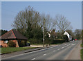
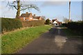
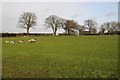
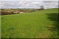
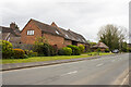
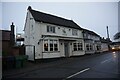
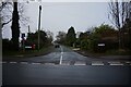
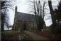
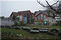
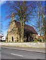
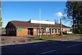
Photos of B61 9NA

Area Information
B61 9NA is a small residential postcode area in Worcestershire, England, nestled within the village of Belbroughton. With a population of 2,207 and a density of 84 people per square kilometre, it reflects a quiet, tightly knit community. Situated approximately 6 miles north of Bromsgrove and 4 miles south of Stourbridge, the area benefits from proximity to larger towns while retaining a village character. Historically, Belbroughton was a hub for the scythe-making industry, with families like the Waldrons and Isaac Nash shaping its industrial legacy. The area’s charm includes landmarks such as Holy Trinity Church, a Domesday-era site with Norman remnants, and the Grade II-listed water wheel at a 16th-century mill. Despite a severe flood in 2008, the area remains resilient, with low flood risk today. Daily life here balances rural tranquillity with practical access to nearby amenities, making it appealing to those seeking a stable, community-focused environment.
- Area Type
- Postcode
- Area Size
- Not available
- Population
- 2207
- Population Density
- 84 people/km²
The property market in B61 9NA is predominantly owner-occupied, with 85% of homes owned by residents rather than rented. The accommodation type is primarily houses, which is typical for a small rural or semi-rural postcode area. This suggests a market skewed towards family homes and long-term residency rather than short-term rental properties. The low population density and small size of the area mean that housing stock is likely limited, with properties concentrated around key locations such as the village centre and nearby historical sites. Buyers should expect a stable market with fewer fluctuations, as the area’s appeal lies in its quiet, established character rather than speculative growth. The high home ownership rate also indicates a community with strong local ties, which can be a draw for those seeking a settled environment.
House Prices in B61 9NA
No properties found in this postcode.
Energy Efficiency in B61 9NA
The lifestyle in B61 9NA is shaped by its proximity to small-scale amenities and historical sites. Within practical reach are five retail outlets, including Budgens Catshill, Co-op Gibbs, and Morrisons Daily, offering essential shopping and services. The village’s character is enhanced by landmarks such as the Holy Trinity Church, the Grade II-listed water wheel, and the Belbroughton Conservation Area, which preserve the area’s heritage. Residents can enjoy a mix of rural tranquillity and practical connectivity, with nearby rail stations facilitating travel to larger towns. The presence of timber-framed dwellings, almshouses, and the 18th-century beer house on High Street adds to the area’s distinct identity. This blend of historical preservation and modern convenience supports a lifestyle that balances community engagement with the ease of access to wider opportunities.
Amenities
Schools
Residents of B61 9NA have access to two primary schools: Dodford First School and Fairfield First School, both of which hold a good Ofsted rating. These institutions provide quality early education for children in the area, supporting families with young dependents. The presence of two primary schools within practical reach ensures that parents have options for their children’s schooling, though no secondary schools are mentioned in the data. The good Ofsted ratings suggest that these schools meet or exceed national standards in teaching quality and student outcomes. For families prioritising education, this proximity to well-rated primary schools is a significant advantage, as it reduces the need for long commutes to larger towns. The mix of school types reflects the area’s focus on foundational education, complementing the community’s emphasis on stability and long-term living.
| Rank | School | Type | Entry gender | Ages |
|---|
Explore more schools in this area
Go to Schools tabDemographics
The population of B61 9NA has a median age of 47, with the majority of residents aged 30–64. This suggests a community of established adults, many of whom are likely in their prime working years. Home ownership is high at 85%, indicating a strong presence of owner-occupied properties rather than rental housing. The predominant accommodation type is houses, which aligns with the area’s rural and semi-rural character. The predominant ethnic group is White, reflecting the broader demographic trends of the region. While no specific data on deprivation is provided, the high home ownership and low crime risk suggest a stable, middle-income community. The age profile implies a population that may be less reliant on schools and childcare services, though the presence of two primary schools nearby caters to younger families. This demographic structure supports a quiet, family-oriented lifestyle with a focus on long-term residency.
Household Size
Accommodation Type
Tenure
Ethnic Group
Religion
Household Composition
Age
Household Deprivation
NS-SEC
Explore more demographic insights in this area
Go to Demographics tabPlanning
Planning Constraints
- Flood RiskPremium
- Ramsar Wetland SitesPremium
- Area of Outstanding Natural BeautyPremium
- Protected Nature ReservePremium
- Protected WoodlandPremium