Area Overview for B61 8HD
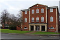
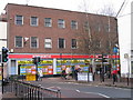
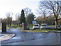
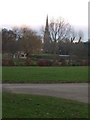
Photos of B61 8HD


Area Information
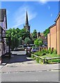
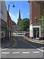
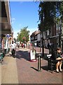
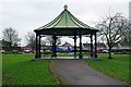
Living in B61 8HD means being part of a tightly knit residential cluster in England’s West Midlands, where 2,038 people inhabit just 474 square metres. This high population density reflects a compact, perhaps even densely packed, community. The area is anchored by Bromsgrove, a town with a mix of historical and modern influences. Sanders Park, a public space gifted by the Sanders family in 1952, lies nearby, offering recreational facilities like tennis courts, a skate park, and a swimming pool. The area’s proximity to Bromsgrove Town Centre and its rail links make it accessible, while the surrounding residential housing suggests a stable, long-term demographic. With a median age of 47 and a majority of residents aged 30–64, the community leans towards adults, many of whom may be homeowners. Daily life here balances practicality with access to amenities, though the small size of the area means every decision about living here carries a sense of proximity and connection to local landmarks.
- Area Type
- Postcode
- Area Size
- 474 m²
- Population
- 2038
- Population Density
- 2538 people/km²
B61 8HD is characterised by a 52% home ownership rate, with houses being the predominant accommodation type. This suggests a market skewed towards owner-occupied properties, rather than rentals. Given the area’s small size and the density of 4,303,869 people per square kilometre, the housing stock is limited, which may make the property market competitive. Buyers should consider that the availability of homes is constrained by the area’s physical boundaries, potentially leading to higher prices or fewer choices. The focus on houses rather than flats or apartments may appeal to families seeking space, though the lack of specific data on property sizes or prices means buyers must rely on local agents for detailed insights. The proximity to Bromsgrove’s amenities and transport links may also influence property values, making location a key factor in this small postcode’s appeal.
House Prices in B61 8HD
No properties found in this postcode.
Energy Efficiency in B61 8HD
Life in B61 8HD is shaped by proximity to Sanders Park, a historic green space with facilities like tennis courts, a skate park, and a swimming pool. The park’s pedestrian link to Bromsgrove Town Centre adds to its appeal, allowing residents to access shops, dining, and services within walking distance. Retail options include Asda, Waitrose, and Aldi, catering to everyday needs. The area’s rail stations connect to broader networks, while the surrounding residential housing suggests a focus on community over commercial development. The compact nature of the area means amenities are concentrated, requiring residents to venture slightly beyond B61 8HD for more specialised services. Nonetheless, the blend of green space, retail, and transport options creates a balanced lifestyle, particularly for those valuing convenience and accessibility.
Amenities
Schools
Residents of B61 8HD have access to a range of educational institutions, including St John’s CofE Foundation Middle School, a primary school, and Bromsgrove School, an independent secondary institution. St John’s Church of England Middle School Academy, an academy with a ‘good’ Ofsted rating, provides further options for families. The mix of school types offers flexibility, with state-funded options for those seeking affordability and independent schools for those prioritising specific curricula or resources. The presence of a ‘good’ rated academy suggests a reliable standard of education, though the absence of data on pupil performance or facilities means potential buyers must investigate further. The proximity of these schools to the area underscores its appeal for families, though the exact catchment areas and application processes are not detailed in the data.
| Rank | School | Type | Entry gender | Ages |
|---|
Explore more schools in this area
Go to Schools tabDemographics
B61 8HD’s population is predominantly White, with 52% of residents owning their homes. The median age of 47 and the most common age range of 30–64 suggest a mature, established community, likely with families and professionals settled in the area. The high home ownership rate indicates stability, though it also means the housing market may be less flexible for renters. The absence of specific data on deprivation or diversity means the area’s social fabric is not fully detailed, but the age profile implies a focus on middle-aged adults, possibly with children in local schools. This demographic mix may influence local services and amenities, with a focus on practical needs over niche offerings. The compact size of the area means that community interactions are likely frequent, though the exact nature of social dynamics remains unquantified in the data.
Household Size
Accommodation Type
Tenure
Ethnic Group
Religion
Household Composition
Age
Household Deprivation
NS-SEC
Explore more demographic insights in this area
Go to Demographics tabPlanning
Planning Constraints
- Flood RiskPremium
- Ramsar Wetland SitesPremium
- Area of Outstanding Natural BeautyPremium
- Protected Nature ReservePremium
- Protected WoodlandPremium