Area Overview for B61 7DR
Photos of B61 7DR


Area Information
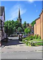
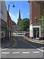
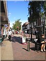
Living in B61 7DR means being part of a small, tightly knit residential cluster in England’s West Midlands. With a population of 2,038, this postcode area is compact but well-served by nearby amenities. The community sits near Bromsgrove Town Centre, with Sanders Park — a historic public space — offering recreational opportunities just a short walk away. Daily life here is shaped by a mature demographic, with a median age of 47 and a strong presence of adults aged 30–64. This suggests a stable, family-oriented environment, with local schools and shops within practical reach. The area’s proximity to rail stations and major retail outlets like Waitrose and Asda makes it convenient for commuters and shoppers. While the housing stock is limited to a small number of properties, the mix of residential clusters and nearby green spaces creates a balanced lifestyle. For those seeking a quiet yet connected community, B61 7DR offers a blend of practicality and accessibility.
- Area Type
- Postcode
- Area Size
- Not available
- Population
- 2038
- Population Density
- 2538 people/km²
The property market in B61 7DR is defined by a 52% home ownership rate, with houses forming the primary accommodation type. This suggests a modest, owner-occupied market rather than a high-turnover rental sector. Given the area’s small size and limited housing stock, buyers should consider nearby zones for broader options. The focus on houses implies a preference for family homes, which may appeal to those seeking space and stability. However, the compact nature of the postcode means the market is unlikely to be highly dynamic. For first-time buyers, the challenge lies in the scarcity of listings, while existing homeowners may benefit from the area’s quiet, low-density character. Proximity to Bromsgrove’s amenities and rail links adds value, though the high crime risk could influence investment decisions.
House Prices in B61 7DR
No properties found in this postcode.
Energy Efficiency in B61 7DR
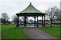
The lifestyle in B61 7DR is enriched by nearby amenities, including retail hubs like Waitrose Bromsgrove and Aldi Birmingham, which cater to daily shopping needs. The area’s proximity to Sanders Park — a historic recreational space with tennis courts, a skate park, and Cotton Pool — provides opportunities for outdoor activities. Spadesbourne Walk connects residents to Bromsgrove Town Centre, blending convenience with access to cultural and commercial offerings. The rail stations within reach offer easy access to broader networks, while the presence of independent and state schools ensures families have educational options. This mix of green spaces, retail, and transport infrastructure creates a balanced lifestyle, combining practicality with community amenities.
Amenities
Schools
Residents of B61 7DR have access to a range of educational institutions. St John’s CofE Foundation Middle School provides primary education, while Bromsgrove School is an independent institution catering to older students. St John’s Church of England Middle School Academy, an academy with a good Ofsted rating, offers a state-funded alternative. This mix of school types — state, independent, and academy — ensures families can choose between different educational philosophies and resources. The presence of a well-rated academy suggests a commitment to quality education, though the independent school may cater to those seeking fee-based options. For parents, the proximity of these schools to the area reduces commuting time, enhancing the appeal of B61 7DR as a family-friendly location.
| Rank | School | Type | Entry gender | Ages |
|---|
Explore more schools in this area
Go to Schools tabDemographics
The population of B61 7DR is predominantly adults aged 30–64, with a median age of 47. This indicates a mature community, likely with established households and a focus on stability. Home ownership rates stand at 52%, suggesting a mix of owner-occupied properties and rental units. The accommodation type is primarily houses, which aligns with the area’s residential character. The predominant ethnic group is White, though specific diversity data is not detailed in the records. The absence of explicit deprivation metrics means the quality of life is inferred from infrastructure and services. With a low flood risk and no environmental constraints like protected woodlands or AONB coverage, the area is free from planning restrictions that could complicate development. However, the high crime risk score of 29/100 — rated as critical — signals a need for caution, particularly for residents prioritising safety.
Household Size
Accommodation Type
Tenure
Ethnic Group
Religion
Household Composition
Age
Household Deprivation
NS-SEC
Explore more demographic insights in this area
Go to Demographics tabPlanning
Planning Constraints
- Flood RiskPremium
- Ramsar Wetland SitesPremium
- Area of Outstanding Natural BeautyPremium
- Protected Nature ReservePremium
- Protected WoodlandPremium