Area Overview for B61 7AD
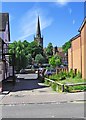
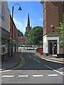
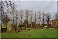
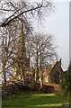
Photos of B61 7AD


Area Information
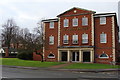
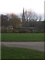
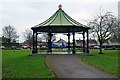
Living in B61 7AD offers a quiet, residential experience within the West Midlands, centred around Bromsgrove’s suburban fabric. The area’s small population of 2,038 suggests a tight-knit community, with homes predominantly in the form of houses rather than flats. This postcode is part of a cluster of residential properties, positioned near Bromsgrove’s town centre and within walking distance of Sanders Park, a historic public space. The median age of 47 and a strong presence of adults aged 30–64 indicate a mature, stable demographic, likely with families and long-term residents. Daily life here balances proximity to local amenities with the calm of a low-density area. The absence of major transport hubs nearby means it caters to those prioritising tranquillity over urban convenience. Residents benefit from the park’s recreational facilities and the nearby rail network, which connects to Bromsgrove and surrounding towns. While the area lacks the vibrancy of larger cities, its charm lies in its simplicity, with homes and community life rooted in local traditions and green spaces.
- Area Type
- Postcode
- Area Size
- Not available
- Population
- 2038
- Population Density
- 2538 people/km²
The property market in B61 7AD is defined by a 52% home ownership rate, indicating a balance between owner-occupied and rental properties. The area’s housing stock consists predominantly of houses, reflecting a preference for detached or semi-detached homes over flats. This suggests a market tailored to families and individuals seeking larger living spaces, rather than a high-density rental sector. Given the small population and limited area, the housing stock is likely constrained, with properties concentrated in a compact cluster. Buyers should consider the limited scope for expansion, as the immediate surroundings may not offer significant new development. The presence of established homes implies a focus on maintenance and long-term value, rather than speculative growth. For those prioritising space and a quieter lifestyle, this area offers a niche opportunity, but competition for properties may be keen due to its small size.
House Prices in B61 7AD
No properties found in this postcode.
Energy Efficiency in B61 7AD
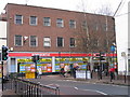
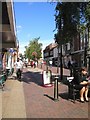
Residents of B61 7AD enjoy access to a range of local amenities, including five retail outlets such as Waitrose Bromsgrove, Asda Bromsgrove, and Aldi Birmingham, ensuring everyday shopping needs are met. The area’s proximity to Sanders Park, a historic recreational space, adds significant value to daily life. The park features tennis courts, a skate park, football pitches, and a water feature, offering opportunities for exercise, leisure, and family activities. The pedestrian link to Bromsgrove’s town centre via Spadesbourne Walk enhances accessibility to dining, services, and cultural attractions. While the area lacks large-scale entertainment venues, its combination of retail, green space, and rail connectivity creates a balanced lifestyle, blending convenience with the tranquillity of a suburban setting.
Amenities
Schools
Residents of B61 7AD have access to three schools within practical reach. St John’s CofE Foundation Middle School is a primary school, while Bromsgrove School is an independent institution, likely catering to older students. St John’s Church of England Middle School Academy, an academy with a ‘good’ Ofsted rating, provides state-funded education with a focus on academic standards. This mix of school types offers families choice: the academy and primary school serve as affordable, local options, while the independent school may appeal to those seeking private education. The presence of a ‘good’-rated academy suggests a reliable state education system, though the independent school’s fees would need to be factored into household budgets. The proximity of these schools to homes in B61 7AD makes it an attractive option for families prioritising educational quality and convenience.
| Rank | School | Type | Entry gender | Ages |
|---|
Explore more schools in this area
Go to Schools tabDemographics
B61 7AD’s population of 2,038 is dominated by adults aged 30–64, reflecting a mature community with a median age of 47. Home ownership sits at 52%, suggesting a mix of owner-occupied properties and rental units. The area is characterised by houses rather than flats, aligning with the preference for family homes. The predominant ethnic group is White, with no data provided on other demographics. This profile indicates a stable, long-term resident base, likely with established careers and family ties. The absence of specific deprivation data means the area’s socioeconomic challenges remain unquantified, but the high proportion of adult residents suggests a focus on settled, working-age populations. The demographic makeup supports a community-oriented environment, where local schools and amenities serve a consistent, localised demand.
Household Size
Accommodation Type
Tenure
Ethnic Group
Religion
Household Composition
Age
Household Deprivation
NS-SEC
Explore more demographic insights in this area
Go to Demographics tabPlanning
Planning Constraints
- Flood RiskPremium
- Ramsar Wetland SitesPremium
- Area of Outstanding Natural BeautyPremium
- Protected Nature ReservePremium
- Protected WoodlandPremium