Area Overview for B49 5EZ
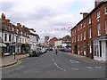
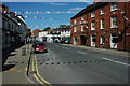
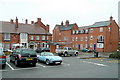
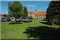
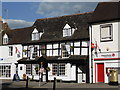
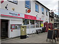
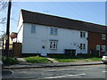
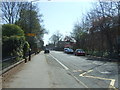
Photos of B49 5EZ


Area Information
Living in B49 5EZ means settling in a small, tightly knit residential cluster in England’s Warwickshire, just 8 miles west of Stratford-upon-Avon. This area, with a population of 1,431 and a density of 225 people per square kilometre, blends historical charm with modern convenience. Its Roman origins are evident in the layout of roads like Ryknild Street and Salt Way, which shaped the town’s development. Today, B49 5EZ is a quiet, family-oriented community with a median age of 47, reflecting a stable demographic of adults aged 30–64. The area’s proximity to Stratford-upon-Avon and Redditch offers easy access to cultural and commercial hubs, while its low crime rate and excellent broadband connectivity cater to both commuters and remote workers. Residents benefit from a mix of historic sites, such as the remnants of Alcester Abbey, and practical amenities like local shops and rail links. This postcode is ideal for those seeking a balance between heritage and contemporary living, with homes predominantly in private ownership and a strong sense of local identity.
- Area Type
- Postcode
- Area Size
- Not available
- Population
- 1431
- Population Density
- 225 people/km²
The property market in B49 5EZ is dominated by owner-occupied homes, with 78% of properties in private hands. This high rate of home ownership indicates a stable, long-term resident base rather than a rental market. The accommodation type is predominantly houses, which aligns with the area’s small, residential character and the absence of high-density housing. Given the postcode’s limited size and the focus on single-family homes, the housing stock is likely to be limited in volume, creating a competitive environment for buyers. For those seeking a home in B49 5EZ, this means properties are likely to be in demand, with limited scope for new developments. The emphasis on houses also suggests that buyers should prioritise larger properties, as flats or apartments are not prominent here. This market dynamic may benefit those looking for a permanent, family-oriented home but could pose challenges for first-time buyers or those seeking investment opportunities.
House Prices in B49 5EZ
No properties found in this postcode.
Energy Efficiency in B49 5EZ
The lifestyle in B49 5EZ is shaped by its proximity to retail and transport hubs, offering a blend of convenience and quiet living. Nearby amenities include major retailers such as Waitrose Alcester, Tesco Alcester, and Co-op Bidford on, which provide essential shopping and dining options. These stores cater to daily needs, from groceries to household goods, reducing the necessity for long commutes. The area’s rail connections, including Wilmcote, Wootton Wawen, and Bearley stations, enhance mobility, allowing residents to access cultural, professional, and recreational opportunities in nearby towns. While the data does not detail parks or leisure facilities, the presence of historical sites like the remnants of Alcester Abbey and the Roman town layout suggests a community with a strong appreciation for heritage. This combination of practical amenities and historical context creates a lifestyle that balances modern convenience with a sense of place rooted in the past.
Amenities
Schools
Residents of B49 5EZ have access to a range of educational institutions, including Alcester Infant School and Alcester Grammar School, both of which operate as primary schools. The latter also functions as an academy with an outstanding Ofsted rating, reflecting high standards of education. This combination of primary schools and an academically rated institution provides families with options for both early education and secondary schooling, though the data does not specify secondary-level offerings. The presence of an outstanding-rated academy suggests a strong focus on academic achievement and resources, which could be a draw for families prioritising quality education. However, the absence of named secondary schools in the data means that further research into local secondary options would be necessary for families with older children. Overall, the school mix supports a community that values education, with a clear emphasis on primary-level provision.
| Rank | School | Type | Entry gender | Ages |
|---|
Explore more schools in this area
Go to Schools tabDemographics
The community in B49 5EZ is predominantly composed of adults aged 30–64, with a median age of 47. This suggests a mature, settled population, likely focused on family life or long-term residency. Home ownership is high at 78%, indicating a stable housing market where most residents live in their own homes rather than renting. The area is characterised by houses rather than flats or apartments, reflecting a preference for private, larger properties. The predominant ethnic group is White, aligning with broader trends in rural England. The low deprivation levels, inferred from the high home ownership and absence of significant planning constraints, suggest a quality of life that supports economic stability. This demographic profile points to a community with established roots, where residents are likely to have strong local ties and a focus on long-term residency over transient living.
Household Size
Accommodation Type
Tenure
Ethnic Group
Religion
Household Composition
Age
Household Deprivation
NS-SEC
Explore more demographic insights in this area
Go to Demographics tabPlanning
Planning Constraints
- Flood RiskPremium
- Ramsar Wetland SitesPremium
- Area of Outstanding Natural BeautyPremium
- Protected Nature ReservePremium
- Protected WoodlandPremium