Area Overview for B48 7NS
Photos of B48 7NS
Area Information
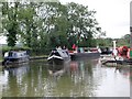
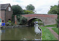
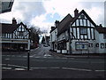
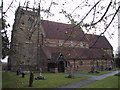
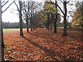
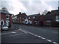
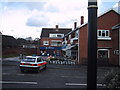
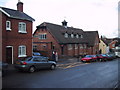
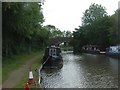
Living in B48 7NS means residing in a specific residential cluster within the historic civil parish of Alvechurch, located in Bromsgrove District, Worcestershire. This compact stretch of housing spans approximately 5,725 square metres and is home to 1,484 people, making it a tightly knit neighbourhood. The postcode area sits at coordinates 52.373022, -1.927982, placing it firmly in the West Midlands region. Residents enjoy proximity to the Birmingham and Worcester Canal, which runs through the wider parish with historical wharves at Alvechurch and Hopwood contributing to the local character. The area offers a quiet existence for adults, with the majority of residents falling into the 30 to 64 years age bracket. You will find yourself in a setting where history is embedded in the landscape, from the 13th-century Church of St Laurence to the former school built by William Butterfield. The small population size creates a manageable environment where daily life moves at a slower pace than in larger urban centres. This specific cluster provides a slice of Worcestershire life that balances residential convenience with access to nearby village amenities. Choosing B48 7NS is choosing a defined world where the boundaries of your home are clear and the community feels intimate.
- Area Type
- Postcode
- Area Size
- 5725 m²
- Population
- 1484
- Population Density
- 1185 people/km²
The property market in B48 7NS is characterised by a strong preference for traditional family housing. Houses account for the primary accommodation type, meaning you will not find a high concentration of flats or apartments in this specific postcode. The remarkable 87% home ownership rate signals that the local market is heavily skewed toward owner-occupiers rather than renters. This dynamic implies that the supply of rental properties is limited, and the available stock is likely dominated by homes already owned by their current occupants. Buyers looking at B48 7NS should understand they are entering a market where sales, rather than tenancies, are the main driver of movement. The area contains a specific residential cluster of 5,725 square metres, which constrains the total number of properties available compared to larger towns. This limited supply often leads to competition among serious buyers. If you are a first-time buyer, securing a property here may require patience or the guidance of a local estate agent who understands the constraints of such a small area. The absence of a rental dominant zone means anyone thinking of moving in must primarily look for sellers, not landlords.
House Prices in B48 7NS
Showing 14 properties
| Address | Type | Beds | Baths | Last Sale Price | Last Sale Date | |
|---|---|---|---|---|---|---|
| 32 Snake Lane, Alvechurch, B48 7NS | house | 2 | - | £385,000 | Jun 2021 | |
| 18 Snake Lane, Alvechurch, B48 7NS | house | - | - | £245,000 | May 2021 | |
| 24 Snake Lane, Alvechurch, B48 7NS | Terraced | 3 | 1 | £265,000 | Nov 2019 | |
| 36 Snake Lane, Alvechurch, B48 7NS | Semi-detached | 2 | - | £241,500 | Jul 2018 | |
| 40 Snake Lane, Alvechurch, B48 7NS | house | - | - | £235,000 | Jun 2017 | |
| 30 Snake Lane, Alvechurch, B48 7NS | house | - | - | £190,000 | Jan 2016 | |
| 34 Snake Lane, Alvechurch, B48 7NS | house | 2 | - | £146,000 | Dec 2011 | |
| 26 Snake Lane, Alvechurch, B48 7NS | house | - | - | £165,000 | Feb 2011 | |
| 22 Snake Lane, Alvechurch, B48 7NS | Semi-detached | - | - | £77,000 | Sep 1998 | |
| 44 Snake Lane, Alvechurch, B48 7NS | Semi-detached | - | - | - | - |
Energy Efficiency in B48 7NS
Lifestyle in B48 7NS is supported by a selection of amenities that are within practical reach of the residents. You can access five retail locations, including Co-op Alvechurch, Waitrose at a nearby site, and Tesco Barnt Green. These supermarkets and shops form the backbone of daily shopping, allowing you to purchase groceries and essentials without travelling far. Retail options extend to five accessible rail-connected spots including Alvechurch Railway Station, Barnt Green Railway Station, and Longbridge Railway Station, which serve both as transport nodes and community hubs. Beyond shopping, the area benefits from the rich heritage of Alvechurch, which includes the Church of St Laurence dating back to 1239. The parish also hosts the famous 1,348-pipe organ and eight bells, adding cultural depth to your living experience. Historical structures like the former school built by William Butterfield and the village hall add character to the streetscape. If you enjoy history, the site of Bordesley Abbey nearby offers a visitor centre and the National Needle Museum. The Birmingham and Worcester Canal runs through the parish, providing scenic routes for walking and boating. Living here grants you access to these historic and recreational assets alongside modern convenience stores.
Amenities
Schools
| Rank | School | Type | Entry gender | Ages |
|---|
Explore more schools in this area
Go to Schools tabDemographics
The community within B48 7NS is defined by stability and long-term settlement patterns. House ownership stands at an impressive 87%, indicating that the majority of residents own their homes outright or with significant equity. This high level of ownership suggests a settled population rather than a transient rental market where people move frequently. Nearly all accommodation in this postcode consists of houses, aligning with the traditional architectural style of Alvechurch which features medieval half-timbered, Georgian, and Victorian buildings. The median age for residents is 47 years old, confirming that the area is dominated by adults between the ages of 30 and 64. This age profile typically correlates with families in school or empty nesters managing retirement assets. The predominant ethnic group is White, reflecting a culturally consistent neighbourhood that has evolved over centuries. With no significant data points suggesting a younger student population or a large influx of new arrivals, the demographic picture remains stable. For those considering this location, the lack of high-density housing and the dominance of owner-occupied homes create an environment where neighbours tend to know one another well over many years.
Household Size
Accommodation Type
Tenure
Ethnic Group
Religion
Household Composition
Age
Household Deprivation
NS-SEC
Explore more demographic insights in this area
Go to Demographics tabPlanning
Planning Constraints
- Flood RiskPremium
- Ramsar Wetland SitesPremium
- Area of Outstanding Natural BeautyPremium
- Protected Nature ReservePremium
- Protected WoodlandPremium